Business Planet Edition 7th Grade Geography Volume 2
People's Education Edition Geography for Seventh Grade Volume 2
Business Planet Edition 7th Grade Geography Volume 1
Business Planet Edition Geography for Grade 8 Volume 1
Shanghai Education Edition Seventh Grade Geography Volume 1
Business Planet Edition Geography for Eighth Grade Volume 2
Hunan Education Edition High School Geography Compulsory Course I
People's Education Edition Geography for Grade 7 Volume 1
Lu Ke version of high school geography compulsory course I
Shanghai Education Edition Geography for Sixth Graders Volume 1
People's Education Edition Geography for Eighth Grade Volume 2
Shanghai Education Edition Seventh Grade Geography Volume 2
Shanghai Education Edition Geography for Sixth Graders Volume 2
People's Education Press High School Geography Compulsory Course 1
Compulsory Course 1 of High School Geography in China Graphics Edition
Hunan Education Edition High School Geography Compulsory Course II

| Category | Format | Size |
|---|---|---|
| People's Education Edition Geography for Seventh Grade Volume 2 | pptx | 6 MB |

"United States" Western Hemisphere countries PPT courseware 4
2024-09-11
Copyright statement: This material is compiled and released by the user of Daoge Resources. The copyright belongs to the author. For commercial use, please contact the copyright owner. If there is any infringement, please contact the webmaster to remove the resource.
Download Points: 0.00
Free Download
Upgrade VIP
Favorite
Views: 3063 / Downloads: 738
Description
"United States" Western Hemisphere countries PPT courseware 4
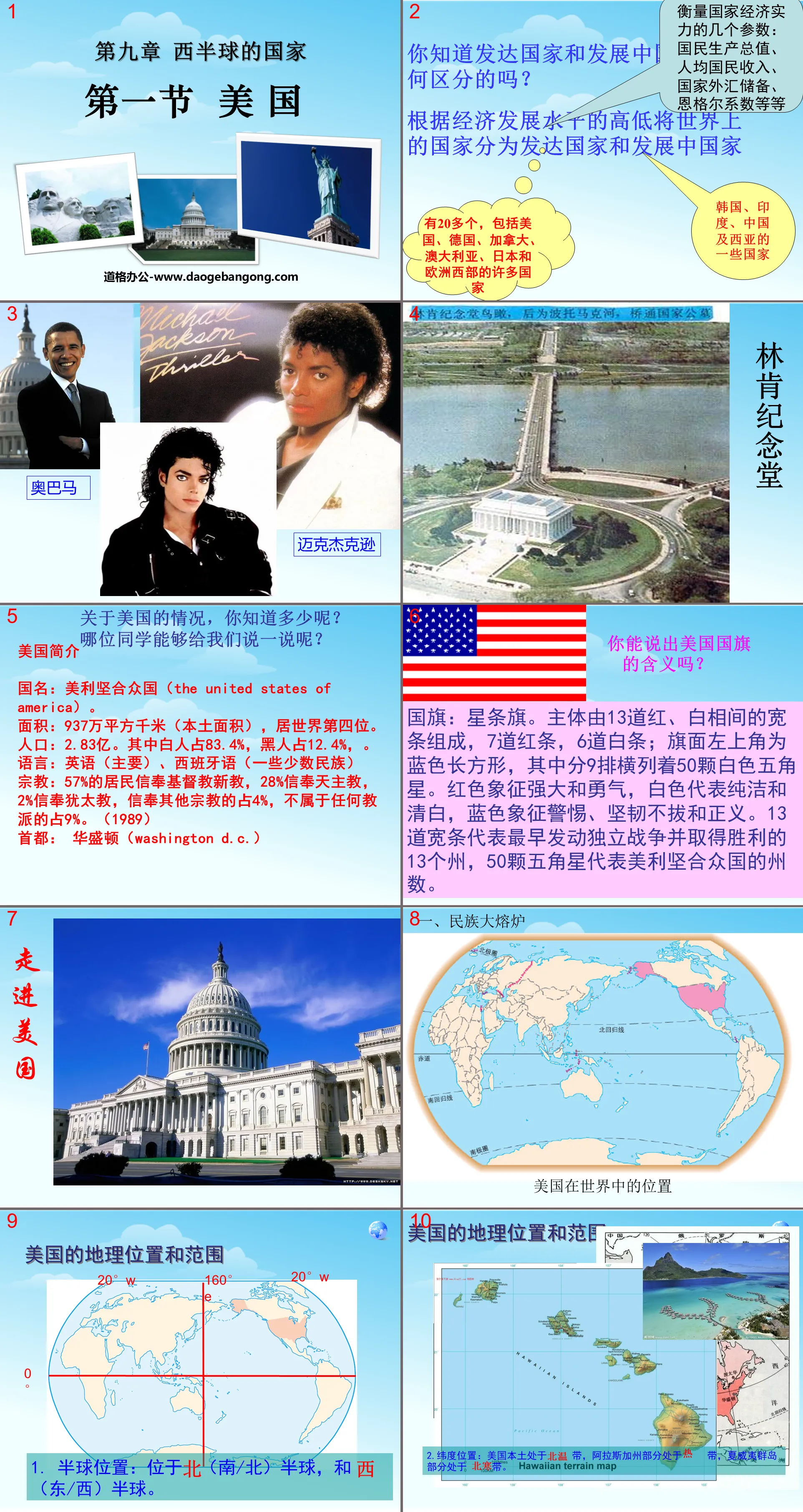
Do you know the difference between developed and developing countries?
Countries in the world are divided into developed and developing countries according to the level of economic development.
Several parameters to measure a country's economic strength: gross national product, per capita national income, national foreign exchange reserves, Engel coefficient, etc.
How much do you know about the situation in the United States?
Which classmate can tell us something?
Introduction to the United States
Country name: The United States of America.
Area: 9.37 million square kilometers (local area), ranking fourth in the world.
Population: 283 million. Among them, white people account for 83.4% and black people account for 12.4%.
Languages: English (mainly), Spanish (some minorities)
Religion: 57% of the residents believe in Protestant Christianity, 28% believe in Catholicism, 2% believe in Judaism, 4% believe in other religions, and 9% do not belong to any denomination. (1989)
Capital: Washington D.C.
Can you tell what the American flag means?
Flag: Stars and Stripes. The main body consists of 13 wide red and white stripes, 7 red stripes and 6 white stripes; the upper left corner of the flag is a blue rectangle with 50 white five-pointed stars arranged in 9 rows. Red symbolizes strength and courage, white represents purity and innocence, and blue symbolizes vigilance, perseverance and justice. The 13 wide bars represent the 13 states that first launched and won the War of Independence, and the 50 five-pointed stars represent the number of states in the United States of America.
Reading material 3: The racial composition of the United States
answer:
1. Among the total population of the United States, the largest number are white immigrants from Europe; followed by black immigrants from Africa; and then yellow people from eastern Asia, of which 4 million are Chinese and overseas Chinese.
2. The indigenous Indians in the United States only account for 1.15% of the total population of the United States. It can be seen that the main population of the United States is immigrants, so the United States can be called a country of immigrants.
3. After immigrants from various countries immigrated to the United States, after long-term integration, they gradually became consistent in language, culture, and lifestyle, forming a unified American nation.
racial inequality
Blacks, Indians, and yellow people, including Chinese, have received unequal treatment in politics, economy, education, and daily life, which reflects the serious racial inequality, wide gap between rich and poor, and other social phenomena that exist in American society.
Practice and compare:
1. The United States is a country of immigrants. Most immigrants come from ( )
A. Africa b. Europe c. Asia D. South America
2. After immigrants from various countries immigrated to the United States, after a long period of integration, they formed a unified ( )
A. French nation b. Yamato nation
C. American nation D. Germanic peoples
crop farming
U.S. agriculture is a typical modern agriculture. The output of wheat, corn, soybeans, cotton, etc. ranks first in the world. Grain production accounts for 20% of the world's total output. The export of agricultural products is the largest item of foreign exchange earnings for the United States.
U.S. agriculture is the world's largest modern agriculture equipped with the most advanced science and technology. It has fully realized mechanization and has a high commodity rate of agricultural products.
The United States is uniquely endowed with its geographical location, climatic conditions and terrain structure. The agricultural land (cultivated land and pasture land) in the United States is approximately 430 million hectares, accounting for about 10% of all agricultural land on the planet. With abundant rainfall and fertile soil, grain output accounts for 1/5 of the world's total output. The output of major agricultural and livestock products such as wheat, corn, soybeans, cotton, and meat ranks first in the world.
3. Read Figure 9.9 and complete the following requirements.
(1) Find out the main agricultural belts (regions) in the United States.
(2) Based on the notes A and B in the figure, summarize the main factors affecting the corn belt and dairy belt.
(3) Refer to the three descriptions of A, B, and C to complete the annotations of D, E, and F in the figure.
A. This is a temperate zone with flat terrain, fertile soil, and relatively high temperatures in spring and summer, which is suitable for corn growth.
B. These two locations are located in the north, with a cold and humid climate, suitable for the growth of pasture. Moreover, this is the manufacturing belt of the United States, with densely populated cities and densely populated areas, so the livestock industry is very developed.
C. The terrain is flat, the soil is fertile, and irrigation is convenient.
D. The latitude is low, the soil is fertile, the temperature is high, and the precipitation is high, which is suitable for the growth of subtropical crops.
E. It is mountainous, with little precipitation, and has large areas of semi-arid grassland and mountain ice and snow melt water.
Challenge yourself
1. The United States is a country of immigrants, and the country’s Turkish residents are ( )
A Black B Caucasian C Indian D Eskimo
2. The United States is the superpower in the world today, and its achievements are due to ( )
A created by white people alone
B Created by Chinese and black people
C was created by Indians
D is created by people of different nationalities and races from all over the world
3. The Mississippi River located in the United States is the world ( )
A The first long river B The second long river C The third long river D The fourth long river
4. The largest freshwater lake in the world is ( )
A Caspian Sea B Lake Superior
C Lake Baikal D Lake Michigan
The world's most developed industrial country
Distribution characteristics of industrial areas in the United States: concentrated in the Northeast;
The western and southern parts are sparse and concentrated around a few cities.
Northeast Industrial Zone: including steel industry, automobile industry, chemical industry, etc. Major industrial cities include Detroit, the automobile city, Pittsburgh, the steel city, the steel center, Chicago, the steel and agricultural product center, and New York, the largest port and financial center in the United States. Southern Industrial Zone: Mainly for the petroleum and aerospace industries. Major industrial cities include Houston. The Pacific Coast Industrial Area is mainly the high-tech industry in the United States. Industrial cities include Los Angeles, San Francisco, and San Diego. The famous Silicon Valley is located southeast of San Francisco.
Keywords: National teaching courseware in the Western Hemisphere, American teaching courseware, New People’s Education Edition seventh grade geography PPT courseware, second volume, seventh grade geography slide courseware download, National PPT courseware download in the Western Hemisphere, American PPT courseware download, .ppt format
For more information about the PPT courseware "Countries of the Western Hemisphere of the United States", please click the "Countries of the Western Hemisphere of the United States ppt" tab.
"American Civil War" PPT download:
"The Civil War in the United States" PPT download part one content: Objective Guide Objective 1: Intensification of the contradiction between the North and the South (causes of the Civil War) The territorial expansion of the United States: By the mid-19th century, the United States had become a major country bordered by the Atlantic Ocean to the east and the Pacific Ocean to the west. . (1) After independence..
"The American Civil War" PPT courseware:
"The American Civil War" PPT courseware Part One: Learning Objectives 1. Read relevant historical materials about the American Civil War and improve the ability to use historical materials to analyze and solve problems. 2. Summarize the basic historical facts of the American Civil War, learn from Lincoln's excellent qualities, and strive to achieve...
"American Civil War" PPT:
"The Civil War in the United States" PPT Part One Content: [Teaching Objectives] Knowledge and Abilities Understand the causes, process, significance of the outbreak of the Civil War and Lincoln's position in American history and other basic historical facts; understand the "Homestead Act", "Emancipation Proclamation", etc. Important documents...
File Info
Update Time: 2024-09-11
This template belongs to Geography courseware People's Education Edition Geography for Seventh Grade Volume 2 industry PPT template
"United States" Western Hemisphere countries PPT courseware 4 Simple campus recruitment activity planning plan summary enterprise and institution recruitment publicity lecture PPT template is a general PPT template for business post competition provided by the manuscript PPT, simple campus recruitment activity planning plan summary enterprise and institution recruitment promotion Lecture PPT template, you can edit and modify the text and pictures in the source file by downloading the source file. If you want more exquisite business PPT templates, you can come to grid resource. Doug resource PPT, massive PPT template slide material download, we only make high-quality PPT templates!
Tips: If you open the template and feel that it is not suitable for all your needs, you can search for related content "United States" Western Hemisphere countries PPT courseware 4 is enough.
How to use the Windows system template
Directly decompress the file and use it with office or wps
How to use the Mac system template
Directly decompress the file and use it Office or wps can be used
Related reading
For more detailed PPT-related tutorials and font tutorials, you can view: Click to see
How to create a high-quality technological sense PPT? 4 ways to share the bottom of the box
Notice
Do not download in WeChat, Zhihu, QQ, built-in browsers, please use mobile browsers to download! If you are a mobile phone user, please download it on your computer!
1. The manuscript PPT is only for study and reference, please delete it 24 hours after downloading.
2. If the resource involves your legitimate rights and interests, delete it immediately.
3. Contact information: service@daogebangong.com
"United States" Western Hemisphere countries PPT courseware 4, due to usage restrictions, it is only for personal study and reference use. For commercial use, please go to the relevant official website for authorization.
(Personal non-commercial use refers to the use of this font to complete the display of personal works, including but not limited to the design of personal papers, resumes, etc.)
Preview
Related Search:
"United States" Western Hemisphere countries PPT courseware 4
2024-09-11
Copyright statement: This material is compiled and released by the user of Daoge Resources. The copyright belongs to the author. For commercial use, please contact the copyright owner. If there is any infringement, please contact the webmaster to remove the resource.
Download Points: 0.00
Free Download
Upgrade VIP
Favorite
Views: 3063 / Downloads: 738


