Business Planet Edition 7th Grade Geography Volume 1
Business Planet Edition 7th Grade Geography Volume 2
People's Education Edition Geography for Seventh Grade Volume 2
Business Planet Edition Geography for Grade 8 Volume 1
Shanghai Education Edition Seventh Grade Geography Volume 1
People's Education Edition Geography for Eighth Grade Volume 2
Hunan Education Edition High School Geography Compulsory Course I
Compulsory Course 1 of High School Geography in China Graphics Edition
Hunan Education Edition High School Geography Compulsory Course II
People's Education Edition Geography for Grade 8 Volume 1
People's Education Edition Geography for Grade 7 Volume 1
Business Planet Edition Geography for Eighth Grade Volume 2
Shanghai Education Edition Geography for Sixth Graders Volume 1
Lu Ke version of high school geography compulsory course I
Shanghai Education Edition Seventh Grade Geography Volume 2
People's Education Press High School Geography Compulsory Course 1
| Category | Format | Size |
|---|---|---|
| Business Planet Edition Geography for Grade 8 Volume 1 | pptx | 6 MB |

"Topography and Relief Characteristics" PPT download
2024-10-22
Copyright statement: This material is compiled and released by the user of Daoge Resources. The copyright belongs to the author. For commercial use, please contact the copyright owner. If there is any infringement, please contact the webmaster to remove the resource.
Download Points: 0.00
Free Download
Upgrade VIP
Favorite
Views: 1437 / Downloads: 479
Description
"Topography and Relief Characteristics" PPT download
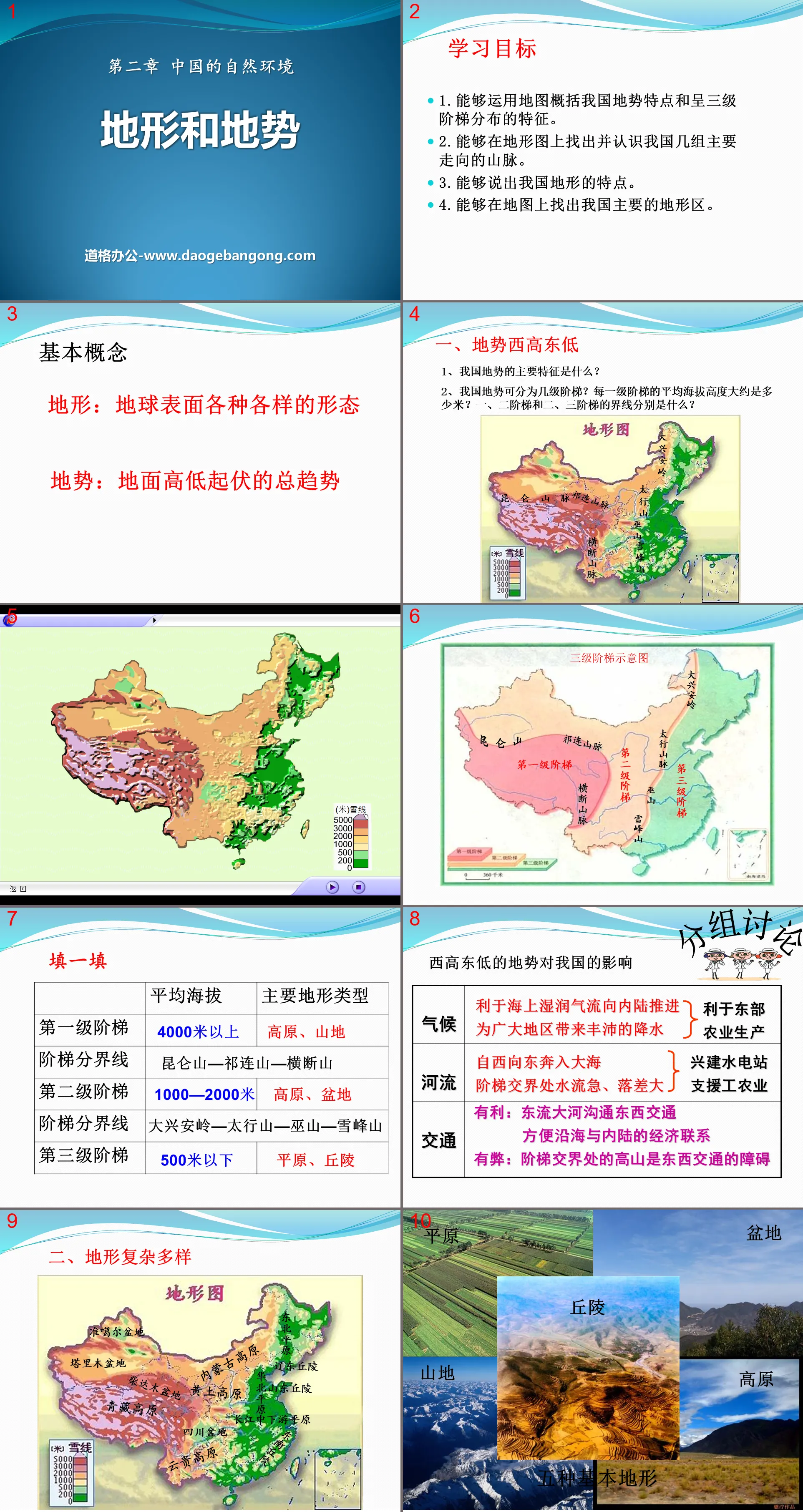
Part One: Learning Objectives
1. Be able to use maps to summarize the terrain characteristics and three-level distribution characteristics of our country.
2. Be able to find and understand the main groups of mountain ranges in my country on topographic maps.
3. Be able to tell the characteristics of our country’s terrain.
4. Be able to find the main terrain areas of our country on the map.
basic concept
Terrain: the various shapes on the earth's surface
Topography: the general tendency of the ground to rise and fall
Topography and relief characteristics PPT, part 2: China’s topography overview
1. The terrain is higher in the west and lower in the east.
1. What are the main characteristics of my country’s terrain?
2. How many levels can my country’s terrain be divided into? Approximately how many meters above sea level is the average altitude of each step? What are the boundaries between the first and second steps and the second and third steps?
group discussion
The influence of the terrain of high in the west and low in the east on our country
climate
Conducive to the advancement of moist air flow from the sea to the inland
Bring abundant rainfall to vast areas
river
Running from west to east into the sea
The water flow is fast and the drop is large at the junction of the stairs.
transportation
Advantages: The great east-flowing river connects east-west traffic
Facilitate economic connections between coastal and inland areas
Disadvantages: The high mountain at the junction of the stairs is an obstacle to east-west traffic
2. Complex and diverse terrain
The terrain types are diverse and the mountainous area is vast.
my country is a mountainous country, with mountainous areas accounting for about 1/3 of the country's total area, and mountainous areas (including mountains, hills, and relatively rugged plateaus) accounting for about 2/3 of the country's total area. The plain area accounts for a little more than 1/10.
3. Main terrain areas
1. Main mountain ranges in my country
mountains running east-west
North: Tianshan-Yinshan
Center: Kunlun Mountains - Qinling Mountains
South: Nanling
Northeast-southwest mountain range
West: Greater Hinggan Mountains - Taihang Mountains - Wushan Mountains - Xuefeng Mountains
Center: Changbai Mountain - Wuyi Mountain
East: Taiwan Mountains
Topography and relief characteristics PPT, the third part of the content: China’s typical relief
four major basins
1. Tarim Basin: It is the largest basin in my country, with the Taklimakan Desert, the largest desert in my country, and the Tarim River, the largest inland river in my country.
2. Junggar Basin: the basin with the highest latitude
3. Qaidam Basin: It is the largest basin with the highest altitude in my country; it has swamps and salt lakes; it is called the "treasure basin" because of its large number of salt mines.
4. Sichuan Basin: There are many hills in the interior, with the Chengdu Plain in the west. It is a purple basin and is known as the "Land of Abundance".
Characteristics of the Three Plains
Northeast Plain: The largest area, black soil; broad terrain, fertile fields thousands of miles away
North China Plain: Alluvial deposits of the Yellow River, Huaihe River, and Haihe River, relatively flat and complete
The plains of the middle and lower reaches of the Yangtze River: the lowest terrain, numerous rivers and lakes, water town, land of plenty
Topography and terrain characteristics PPT, part 4 content: in-class training
1. The main terrain types distributed on the third level of the ladder are ( )
A.Hills and plains B.Hills and basins
C. Mountains and plateaus D. plains and plateaus
2. The directions of the following mountain ranges are generally the same ( )
① Tianshan Mountains ② Daxinganling Mountains ③ Taihang Mountains
④Kunlun Mountain ⑤Qinling Mountains ⑥Wushan Mountain
A. ①②④ B. ①③⑤
C. ②③⑥ D. ③④⑤
3. The mountain range represented by ① in the picture below is ( )
A. altai mountains
B. Kunlun Mountains
C. Himalayas
D. Tianshan
5. Among the following mountains, the one with a different direction from the other three mountains is ( )
A.Daxinganling B.Nanling
C.Changbai Mountain D.Taiwan Mountains
6. Which of the following mountain ranges does not run northeast-southwest ( )
A.Daxinganling B.Taihang Mountains
C. Wushan D. Tianshan
Keywords: Free download of Geography PPT courseware for the first volume of eighth grade version of Business Planet Edition, PPT courseware on topography and relief characteristics, .PPT format;
For more information about the "Topography and Relief Characteristics" PPT courseware, please click on the "Topography and Relief Characteristics" ppt tab.
"Topography and Relief Characteristics" PPT courseware:
"Topography and Relief Characteristics" PPT courseware Part One: Thinking by looking at pictures Looking at pictures: Thinking about the topographic distribution characteristics of Asia? The middle part is high and the surrounding areas are low; mainly plateaus and mountains; there is a huge difference between high and low. Picture observation: 1. Combined with the terrain profile near 360N, talk about the journey from point A to...
"Topography and Relief Characteristics" PPT:
"Topography and Relief Characteristics" PPT Part One: Characteristics of terrain The terrain is high in the west and low in the east. Terrain characteristics of my country The terrain is high in the west and low in the east, with a three-level ladder distribution. Exploring climate issues 1. The terrain of my country's mainland is high in the west and low in the east, facing the ocean. This distribution...
File Info
Update Time: 2024-10-22
This template belongs to Geography courseware Business Planet Edition Geography for Grade 8 Volume 1 industry PPT template
"Topography and Relief Characteristics" PPT download Simple campus recruitment activity planning plan summary enterprise and institution recruitment publicity lecture PPT template is a general PPT template for business post competition provided by the manuscript PPT, simple campus recruitment activity planning plan summary enterprise and institution recruitment promotion Lecture PPT template, you can edit and modify the text and pictures in the source file by downloading the source file. If you want more exquisite business PPT templates, you can come to grid resource. Doug resource PPT, massive PPT template slide material download, we only make high-quality PPT templates!
Tips: If you open the template and feel that it is not suitable for all your needs, you can search for related content "Topography and Relief Characteristics" PPT download is enough.
How to use the Windows system template
Directly decompress the file and use it with office or wps
How to use the Mac system template
Directly decompress the file and use it Office or wps can be used
Related reading
For more detailed PPT-related tutorials and font tutorials, you can view: Click to see
How to create a high-quality technological sense PPT? 4 ways to share the bottom of the box
Notice
Do not download in WeChat, Zhihu, QQ, built-in browsers, please use mobile browsers to download! If you are a mobile phone user, please download it on your computer!
1. The manuscript PPT is only for study and reference, please delete it 24 hours after downloading.
2. If the resource involves your legitimate rights and interests, delete it immediately.
3. Contact information: service@daogebangong.com
"Topography and Relief Characteristics" PPT download, due to usage restrictions, it is only for personal study and reference use. For commercial use, please go to the relevant official website for authorization.
(Personal non-commercial use refers to the use of this font to complete the display of personal works, including but not limited to the design of personal papers, resumes, etc.)
Preview
Related Search:
"Topography and Relief Characteristics" PPT download
2024-10-22
Copyright statement: This material is compiled and released by the user of Daoge Resources. The copyright belongs to the author. For commercial use, please contact the copyright owner. If there is any infringement, please contact the webmaster to remove the resource.
Download Points: 0.00
Free Download
Upgrade VIP
Favorite
Views: 1437 / Downloads: 479


