Business Planet Edition 7th Grade Geography Volume 1
Business Planet Edition 7th Grade Geography Volume 2
People's Education Edition Geography for Seventh Grade Volume 2
Business Planet Edition Geography for Grade 8 Volume 1
Shanghai Education Edition Seventh Grade Geography Volume 1
People's Education Edition Geography for Eighth Grade Volume 2
Hunan Education Edition High School Geography Compulsory Course I
People's Education Edition Geography for Grade 7 Volume 1
Shanghai Education Edition Geography for Sixth Graders Volume 1
Business Planet Edition Geography for Eighth Grade Volume 2
Compulsory Course 1 of High School Geography in China Graphics Edition
Hunan Education Edition High School Geography Compulsory Course II
People's Education Edition Geography for Grade 8 Volume 1
Lu Ke version of high school geography compulsory course I
People's Education Press High School Geography Compulsory Course 1
Shanghai Education Edition Seventh Grade Geography Volume 2
| Category | Format | Size |
|---|---|---|
| People's Education Edition Geography for Eighth Grade Volume 2 | pptx | 6 MB |

"The Arid Treasure of the Tarim Basin" Northwest Region PPT Courseware 4
2024-10-09
Copyright statement: This material is compiled and released by the user of Daoge Resources. The copyright belongs to the author. For commercial use, please contact the copyright owner. If there is any infringement, please contact the webmaster to remove the resource.
Download Points: 0.00
Free Download
Upgrade VIP
Favorite
Views: 3676 / Downloads: 182
Description
"The Arid Treasure of the Tarim Basin" Northwest Region PPT Courseware 4
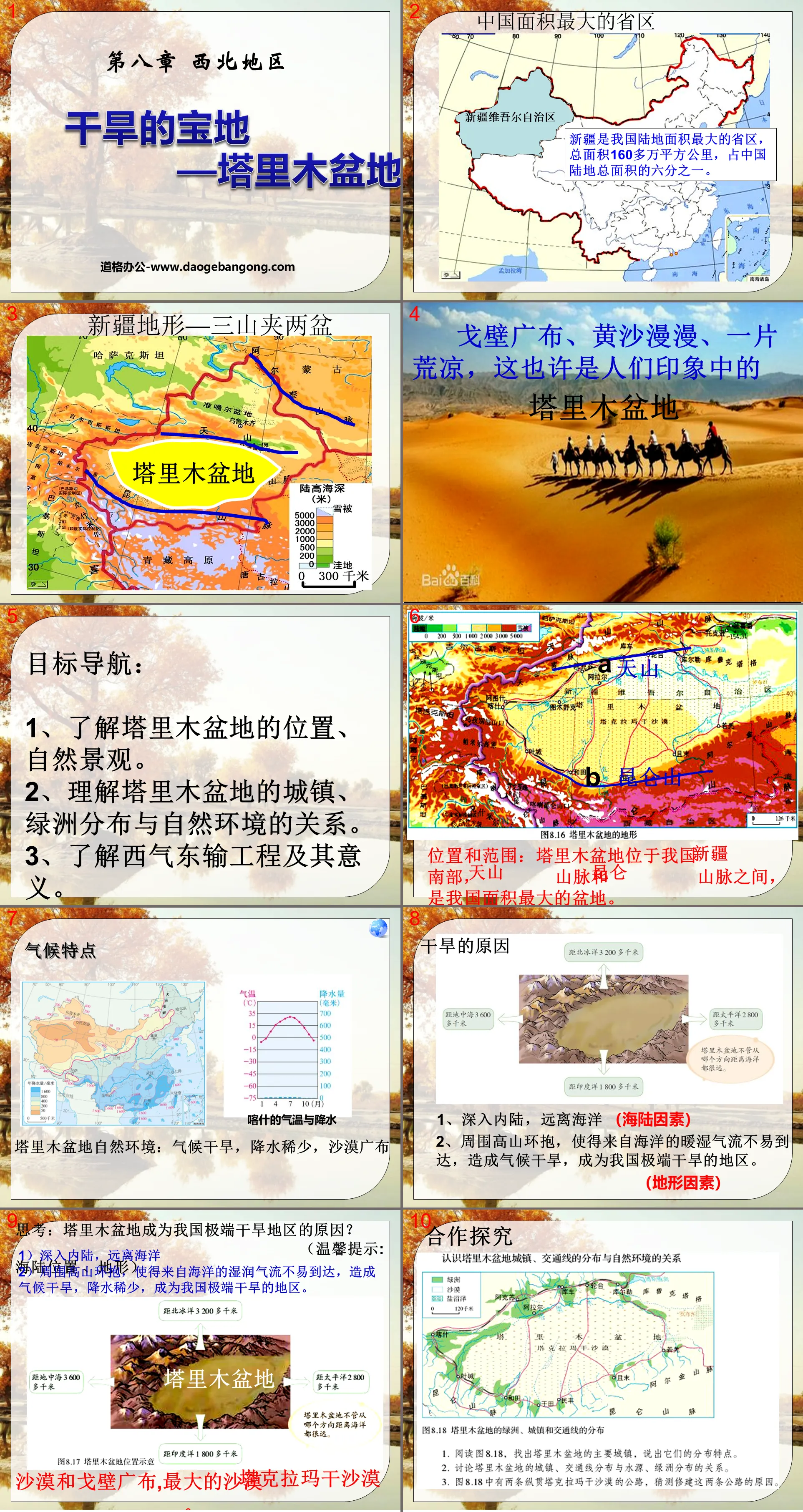
Target navigation:
1. Understand the location and natural landscape of the Tarim Basin.
2. Understand the relationship between the distribution of towns and oases and the natural environment in the Tarim Basin.
3. Understand the West-East Gas Transmission Project and its significance.
Location and scope: The Tarim Basin is located in the southern part of my country's ________, between the ________ Mountains and the ________ Mountains. It is the largest basin in my country.
Climate characteristics
Natural environment of the Tarim Basin: arid climate, scarce precipitation, and widespread deserts
causes of drought
1. Go deep inland and away from the ocean
2. Surrounded by high mountains, it is difficult for warm and humid air from the ocean to reach, causing a dry climate and making it an extremely arid area in my country.
Understand the relationship between towns in the Tarim Basin, the distribution of traffic lines and the natural environment
1. Read Figure 8.18, find out the main towns in the Tarim Basin, and describe their distribution characteristics.
The main towns are: Korla, Luntai, Kuqa, Aksu, Kashgar, Yecheng, Hotan, Yutian, Minfeng, Qiemo, Ruoqiang, etc.
Cities and towns are mainly distributed in oases and are distributed in a ring along the edge of the Tarim Basin.
2. Development of resources
The Tarim Basin is rich in ______ resources, especially ______ reserves, which account for about a quarter of the country's total onshore reserves.
The West-East Gas Pipeline has an annual gas transmission capacity of 12 billion cubic meters
1. The starting and ending points of the line? Lunnan of the Tarim Basin in Xinjiang—Shanghai
2. How many times does the West-East Gas Pipeline cross the Yellow River?
3. Which provincial administrative regions does the West-East Gas Pipeline pass from west to east?
The Second West-East Gas Pipeline has an annual gas transmission capacity of 30 billion cubic meters
1. Line starting and ending points
Xinjiang Horgos Port-----Guangzhou
2. Second West-East Gas Pipeline (Main Line)
Which provincial administrative regions does it pass through from west to east?
Significance to the western region: giving full play to the energy advantages of the western region; driving economic development in the western region.
Significance to the eastern region: Alleviating energy shortages in the eastern region; optimizing the energy structure in the eastern region.
Expand and extend
How should "win-win economic and ecological benefits" be reflected in the development and utilization of resources in the western region.
The Tarim Basin has a fragile environment. While developing and utilizing oil and gas resources, it is necessary to take various measures to avoid damaging the environment and strengthen the environmental protection of the oasis.
Exploring Xinjiang’s “Best of China”
China's largest province
China's province farthest from the ocean
China has the most neighboring provinces and regions
China’s largest basin (Tarim Basin)
The largest inland river in China (Tarimu River)
The largest desert in China (Taklimakan Desert)
The place where the highest temperature occurs in China (Turpan Basin)
The lowest place in China (Aiding Lake in Turpan Basin)
The place with the least rainfall in China (Tokxun in Turpan Basin)
power enhanced
1. The largest basin in my country is ( )
A. Sichuan Basin B. Tarim Basin
C. Qaidam Basin D. Turpan Basin
2. Regarding the description of the Tarim Basin, which one is correct ( )
① Warm temperate zone ② Semi-arid area ③ Arid area ④ Vast grassland
⑤The surface vegetation is mainly desert
A, ①③⑤ B, ①②④ C, ①③④ D, ①②⑤
3. "The solitary smoke is straight in the desert, and the sun is setting in the long river" is the most suitable thing to describe the following areas ( )
A. The middle and lower reaches of the Yangtze River B. Shandong hilly areas
C. Brahmaputra Valley D. Lower Tarim River area
4. The population and cities in the Tarim Basin are mainly distributed in ( )
A. Oasis area B. Desert area
C. Salt swamp area D. Desert and oases
5. The dominant factors affecting the population and urban distribution of the Tarim Basin are ( )
A. Forest resources B. Water resources
C. Mineral resources D. Wildlife
6. Compared with other regions in my country, the advantageous climate conditions for the development of high-quality agriculture in oasis areas are ( )
A. Sufficient sunshine, large temperature difference between day and night B. Abundant water and heat, good thermal conditions
C. Sufficient light and heat, long frost-free period D. Rain and heat in the same period, high multiple cropping index
Keywords: Northwest region teaching courseware, arid treasure land Tarim Basin teaching courseware, New People's Education Edition eighth grade geography PPT courseware volume 2, eighth grade geography slide courseware download, northwest region PPT courseware download, arid treasure land Tarim Basin PPT courseware download ,.ppt format
For more information about the PPT courseware "The Tarim Basin, a Dry Treasure Land in Northwest China", please click the Tarim Basin, a Dry Treasure Land in Northwest China ppt tag.
"The Arid Treasure of the Tarim Basin" Northwest Region PPT Courseware 3:
"The Arid Treasure of the Tarim Basin" Northwest Region PPT Courseware 3 Learning Objective: Please hand-draw a map of the location of the Tarim Basin, and mark the locations of the Tianshan Mountains, Kunlun Mountains and Taklimakan Desert on the map? And analyze the reasons why the Tarim Basin has become an extremely arid area in my country...
"The Arid Treasure of the Tarim Basin" Northwest Region PPT Courseware 2:
"The Arid Treasure Tarim Basin" PPT courseware for the northwest region 2 1. Widespread desert and Gobi 1. Location and scope: The Tarim Basin is located in the south of ___, between the ___ Mountains and the ___ Mountains. It is the largest area in my country. basin. 2. What are the climate characteristics of the Tarim Basin? ..
"The Arid Treasure of the Tarim Basin" Northwest Region PPT courseware:
"The Arid Treasure of the Tarim Basin" Northwest Region PPT Courseware 1. Understanding the Tarim Basin Talk: What do you think are the characteristics of the natural landscape of the Tarim Basin? The natural environment of the Tarim Basin: arid climate, scarce precipitation, and widespread deserts. It is the largest desert in my country..
File Info
Update Time: 2024-10-09
This template belongs to Geography courseware People's Education Edition Geography for Eighth Grade Volume 2 industry PPT template
"The Arid Treasure of the Tarim Basin" Northwest Region PPT Courseware 4 Simple campus recruitment activity planning plan summary enterprise and institution recruitment publicity lecture PPT template is a general PPT template for business post competition provided by the manuscript PPT, simple campus recruitment activity planning plan summary enterprise and institution recruitment promotion Lecture PPT template, you can edit and modify the text and pictures in the source file by downloading the source file. If you want more exquisite business PPT templates, you can come to grid resource. Doug resource PPT, massive PPT template slide material download, we only make high-quality PPT templates!
Tips: If you open the template and feel that it is not suitable for all your needs, you can search for related content "The Arid Treasure of the Tarim Basin" Northwest Region PPT Courseware 4 is enough.
How to use the Windows system template
Directly decompress the file and use it with office or wps
How to use the Mac system template
Directly decompress the file and use it Office or wps can be used
Related reading
For more detailed PPT-related tutorials and font tutorials, you can view: Click to see
How to create a high-quality technological sense PPT? 4 ways to share the bottom of the box
Notice
Do not download in WeChat, Zhihu, QQ, built-in browsers, please use mobile browsers to download! If you are a mobile phone user, please download it on your computer!
1. The manuscript PPT is only for study and reference, please delete it 24 hours after downloading.
2. If the resource involves your legitimate rights and interests, delete it immediately.
3. Contact information: service@daogebangong.com
"The Arid Treasure of the Tarim Basin" Northwest Region PPT Courseware 4, due to usage restrictions, it is only for personal study and reference use. For commercial use, please go to the relevant official website for authorization.
(Personal non-commercial use refers to the use of this font to complete the display of personal works, including but not limited to the design of personal papers, resumes, etc.)
Preview
Related Search:
"The Arid Treasure of the Tarim Basin" Northwest Region PPT Courseware 4
2024-10-09
Copyright statement: This material is compiled and released by the user of Daoge Resources. The copyright belongs to the author. For commercial use, please contact the copyright owner. If there is any infringement, please contact the webmaster to remove the resource.
Download Points: 0.00
Free Download
Upgrade VIP
Favorite
Views: 3676 / Downloads: 182


