The second volume of history for eighth grade compiled by the People's Education Publishing House
Zhonghua Book Company Edition Eighth Grade History Volume 2
Zhonghua Book Company Edition Seventh Grade History Volume 2
People's Education Edition Eighth Grade History Volume 1
Yuelu Edition Seventh Grade History Volume 2
People's Education Edition History and Society 9th Grade Part II
People's Education Press History and Society Grade 9
Volume 1 of the seventh grade history compiled by the People's Education Publishing House
People's Education Press Seventh Grade History Volume 1
People's Education Press History and Society for Grade 8 Volume 1
East China Normal University Edition Seventh Grade History Volume 1
People's Education Press Ninth Grade History Volume 2
People's Education Press History and Society Grade 7
People's Education Edition Eighth Grade History Volume 2
Yuelu Edition Seventh Grade History Volume 1
People's Education Press Seventh Grade History Volume 2
| Category | Format | Size |
|---|---|---|
| People's Education Press History and Society Grade 7 | pptx | 6 MB |

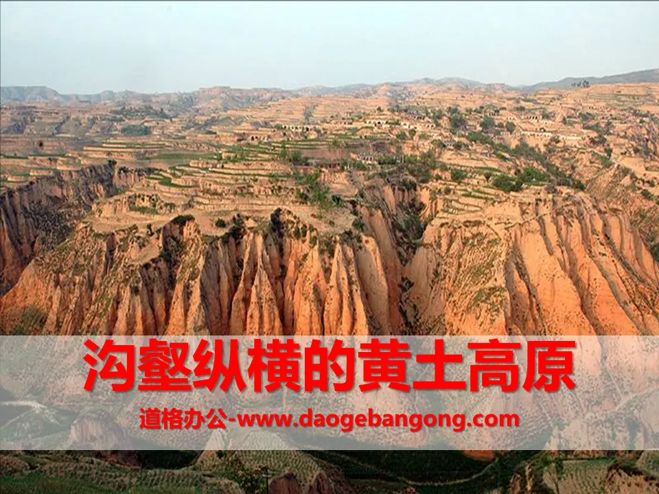
"The Loess Plateau with crisscrossed ravines" Water and soil support one person PPT
2024-09-08
Copyright statement: This material is compiled and released by the user of Daoge Resources. The copyright belongs to the author. For commercial use, please contact the copyright owner. If there is any infringement, please contact the webmaster to remove the resource.
Download Points: 0.00
Free Download
Upgrade VIP
Favorite
Views: 2344 / Downloads: 610
Description
"The Loess Plateau with crisscrossed ravines" Water and soil support one person PPT
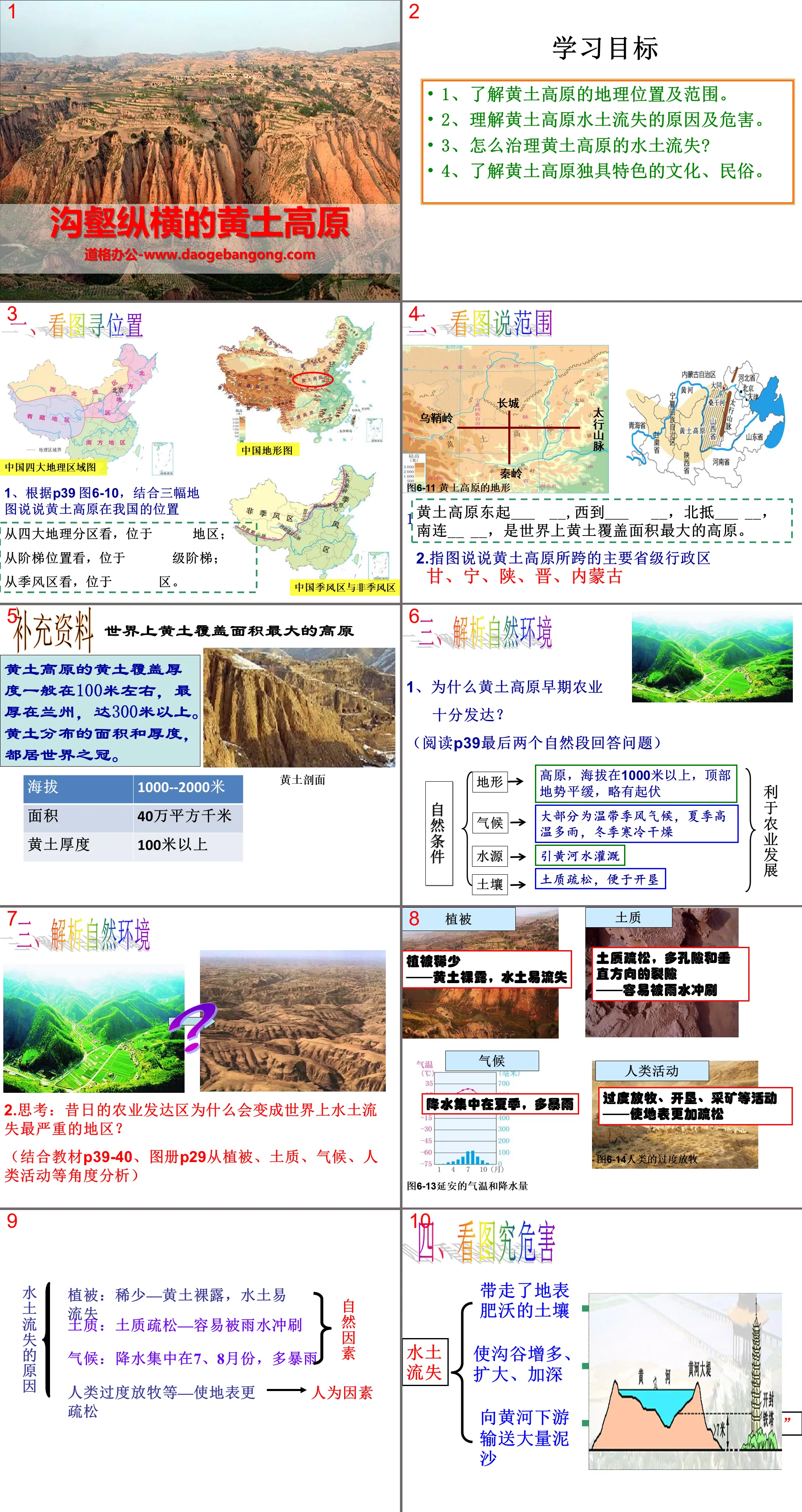
Part One: Learning Objectives
1. Understand the geographical location and scope of the Loess Plateau.
2. Understand the causes and hazards of soil and water loss in the Loess Plateau.
3. How to control soil and water loss in the Loess Plateau?
4. Understand the unique culture and folk customs of the Loess Plateau.
Loess Plateau PPT with crisscrossed ravines, part 2: learn from pictures
1. Look at the picture to find the location
1. Based on Figure 6-10 on P39, let’s talk about the location of the Loess Plateau in my country based on the three maps.
Judging from the four major geographical divisions, it is located in the region;
Viewed from the stair position, it is located on the first step;
Viewed from the monsoon area, it is located in the district.
2. Look at the picture to describe the scope.
1. The Loess Plateau starts from ___ __ in the east, reaches ___ __ in the west, reaches ___ __ in the north, and connects __ __ in the south. It is the plateau with the largest loess coverage area in the world.
2. Describe with pictures the main provincial-level administrative regions that the Loess Plateau spans
Gansu, Ningxia, Shaanxi, Shanxi, Inner Mongolia
3. Analyze the natural environment
1. Why was agriculture so developed in the early days of the Loess Plateau?
(Read the last two paragraphs of P39 and answer the questions)
2. Thinking: Why did the former agriculturally developed areas become the areas with the most severe soil erosion in the world?
(Combined with textbook P39-40 and atlas P29, analyze from the perspectives of vegetation, soil quality, climate, human activities, etc.)
4. Look at the pictures to study the hazards
soil erosion
Take away the fertile soil on the surface
Increase, expand, and deepen ravines
Transporting large amounts of sediment to the lower reaches of the Yellow River
PPT of the Loess Plateau with crisscrossed ravines, the third part: Loess Culture
Loess culture - waist drum
Ansai waist drum has a history of more than 2,000 years and is among the first batch of national intangible cultural heritage.
Loess Culture——White Sheep Belly Scarf
Loess culture - food
People here mainly eat pasta. They have three meals a day and cannot do without it every day. Noodles and steamed buns are the main ones. Shaanxi noodles are thicker, wider and longer than people imagine. Belt. Guokui is also a Shaanxi noodle dish.
PPT on the Loess Plateau with crisscrossed ravines, part 4: In-person inspection
1. The Loess Plateau starts from ______ in the east, _______ in the west, _______ in the south, and ________ in the north.
2. The Loess Plateau is the largest __________ plateau in the world and also the area with the most severe __________.
3. The unique folk houses on the Loess Plateau are ( )
A. Siheyuan B. Cave dwelling C. Qilou D. Bamboo house
4. The effective measures to build the ecological environment of the Loess Plateau and improve the environment are ( )
A. Planting trees and grass B. Building terraces on steep slopes
C. Develop all farming operations D. Develop all animal husbandry
5. The mountain range between the Loess Plateau and the North China Plain is ( )
A. Qinling Mountains B. Taihang Mountains C. Wushan Mountains D. Daxinganling Mountains
Keywords: PPT courseware for the second volume of the seventh grade of the People's Education Press on history and society can be downloaded for free, where water and soil support a person, PPT download, and the Loess Plateau with its crisscrossed ravines, PPT download, in .PPT format;
For more information about the PPT courseware "A Side of Water and Soil Supports a Side of People, a Loess Plateau with crisscrossed ravines", please click on the "A Side of Water and Soil Supports a Side of People, a Loess Plateau with crisscrossed ravines" ppt tag.
"How to Carry out Social Investigation" The soil and water support the people PPT:
"How to Carry out Social Investigation" PPT Part One: The meaning of social investigation. What is social investigation? It refers to the application of scientific methods to conduct on-site inspections of specific social phenomena to understand the various causes and related connections of their occurrence, so as to propose untie..
"The Holy City on the Plateau - Lhasa" The soil and water support each person PPT courseware:
"The Holy City of Lhasa on the Plateau" PPT courseware where the soil and water support the people. Part 1: Introduction of the new lesson Lhasa Holy Land, Buddha Land and Holy City. Where is the focus of learning: Where is the Holy City? How about: In what ways does the Holy City perform? Why: Why did it become a holy city? ..
"The Holy City on the Plateau - Lhasa" The soil and water support the people PPT:
"The Holy City of Lhasa on the Plateau" A land and water support a people PPT Part One: Geographical Location Lhasa City is located in the southeast of Tibet, on the north bank of the Lhasa River, a tributary of the Brahmaputra River, and is the capital of the Tibet Autonomous Region. Terrain Terrain: Plateau (Qinghai-Tibet Plateau) with an altitude of more than 3,600 meters..
File Info
Update Time: 2024-09-08
This template belongs to History courseware People's Education Press History and Society Grade 7 industry PPT template
"The Loess Plateau with crisscrossed ravines" Water and soil support one person PPT Simple campus recruitment activity planning plan summary enterprise and institution recruitment publicity lecture PPT template is a general PPT template for business post competition provided by the manuscript PPT, simple campus recruitment activity planning plan summary enterprise and institution recruitment promotion Lecture PPT template, you can edit and modify the text and pictures in the source file by downloading the source file. If you want more exquisite business PPT templates, you can come to grid resource. Doug resource PPT, massive PPT template slide material download, we only make high-quality PPT templates!
Tips: If you open the template and feel that it is not suitable for all your needs, you can search for related content "The Loess Plateau with crisscrossed ravines" Water and soil support one person PPT is enough.
How to use the Windows system template
Directly decompress the file and use it with office or wps
How to use the Mac system template
Directly decompress the file and use it Office or wps can be used
Related reading
For more detailed PPT-related tutorials and font tutorials, you can view: Click to see
How to create a high-quality technological sense PPT? 4 ways to share the bottom of the box
Notice
Do not download in WeChat, Zhihu, QQ, built-in browsers, please use mobile browsers to download! If you are a mobile phone user, please download it on your computer!
1. The manuscript PPT is only for study and reference, please delete it 24 hours after downloading.
2. If the resource involves your legitimate rights and interests, delete it immediately.
3. Contact information: service@daogebangong.com
"The Loess Plateau with crisscrossed ravines" Water and soil support one person PPT, due to usage restrictions, it is only for personal study and reference use. For commercial use, please go to the relevant official website for authorization.
(Personal non-commercial use refers to the use of this font to complete the display of personal works, including but not limited to the design of personal papers, resumes, etc.)
Preview
Related Search:
"The Loess Plateau with crisscrossed ravines" Water and soil support one person PPT
2024-09-08
Copyright statement: This material is compiled and released by the user of Daoge Resources. The copyright belongs to the author. For commercial use, please contact the copyright owner. If there is any infringement, please contact the webmaster to remove the resource.
Download Points: 0.00
Free Download
Upgrade VIP
Favorite
Views: 2344 / Downloads: 610


