Business Planet Edition 7th Grade Geography Volume 2
People's Education Edition Geography for Seventh Grade Volume 2
Business Planet Edition 7th Grade Geography Volume 1
Business Planet Edition Geography for Grade 8 Volume 1
Shanghai Education Edition Seventh Grade Geography Volume 1
Business Planet Edition Geography for Eighth Grade Volume 2
Hunan Education Edition High School Geography Compulsory Course I
People's Education Edition Geography for Grade 7 Volume 1
Shanghai Education Edition Geography for Sixth Graders Volume 1
Lu Ke version of high school geography compulsory course I
Shanghai Education Edition Seventh Grade Geography Volume 2
Shanghai Education Edition Geography for Sixth Graders Volume 2
People's Education Edition Geography for Eighth Grade Volume 2
People's Education Press High School Geography Compulsory Course 1
Compulsory Course 1 of High School Geography in China Graphics Edition
Compulsory Course 2 of High School Geography in China Graphics Edition

| Category | Format | Size |
|---|---|---|
| People's Education Edition Geography for Grade 8 Volume 1 | pptx | 6 MB |

"Territory" View China from the World PPT Courseware 3
2024-09-05
Copyright statement: This material is compiled and released by the user of Daoge Resources. The copyright belongs to the author. For commercial use, please contact the copyright owner. If there is any infringement, please contact the webmaster to remove the resource.
Download Points: 0.00
Free Download
Upgrade VIP
Favorite
Views: 4029 / Downloads: 709
Description
"Territory" View China from the World PPT Courseware 3
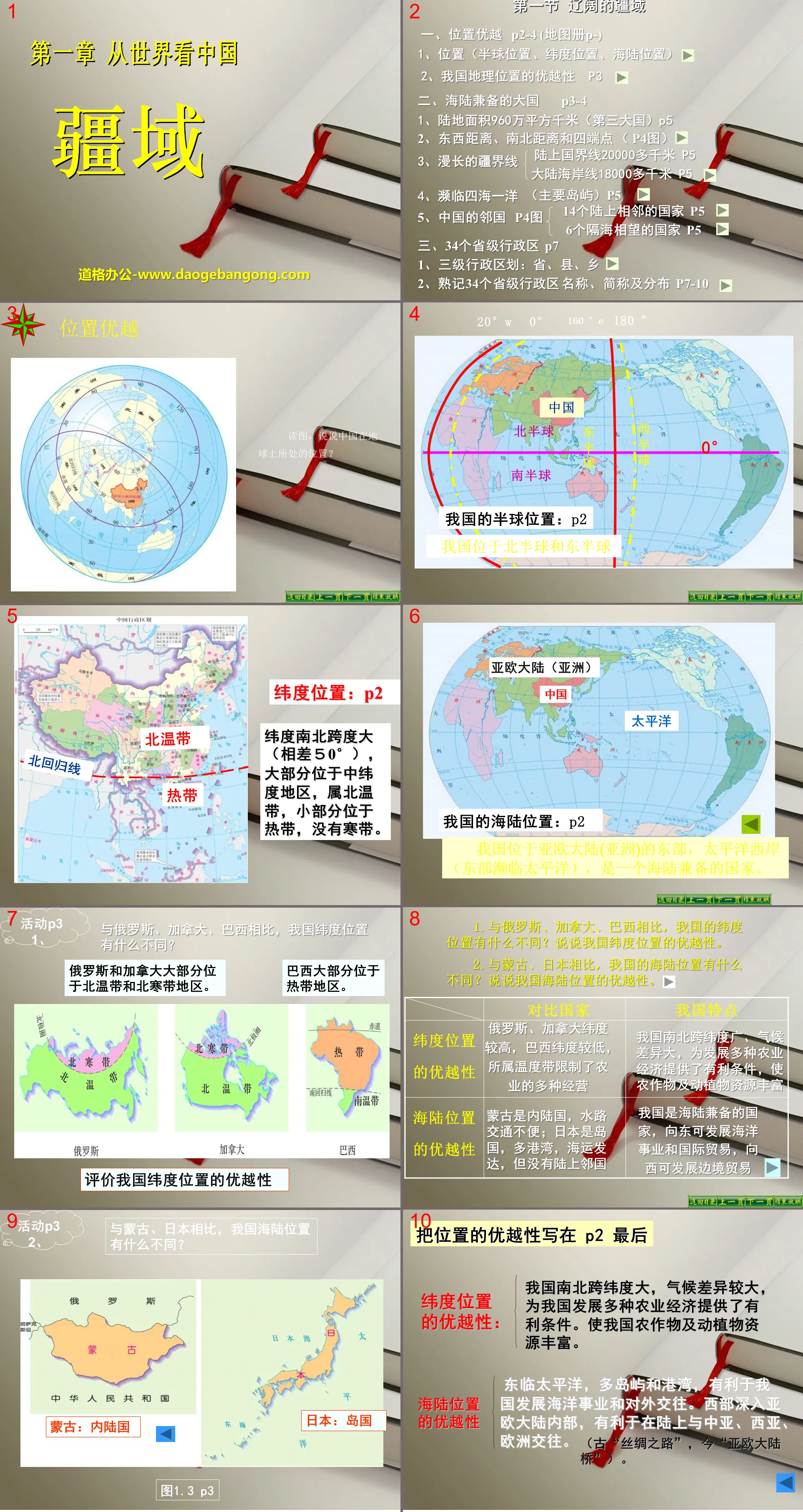
Section 1 The vast territory
1. Excellent location P2-4 (Atlas P-)
1. Location (hemispheric location, latitude location, sea and land location)
2. The superior geographical location of our country
2. A big country with both land and sea
1. Land area 9.6 million square kilometers (third largest country) P5
2. East-west distance, north-south distance and four endpoints (P4 picture)
3. Long borders
The land border is more than 20,000 kilometers P5
The mainland coastline is more than 18,000 kilometers P5
4. Bordering four seas and one ocean (main islands) P5
5. China’s neighboring countries P4 map
14 land-adjacent countries P5
6 countries facing each other across the sea P5
3. 34 provincial-level administrative regions P7
1. Three-level administrative divisions: province, county, township
2. Memorize the names, abbreviations and distribution of 34 provincial-level administrative regions P7-10
Activity P3 1.
Compared with Russia, Canada, and Brazil, what are the differences in my country's latitude and location?
Russia and Canada are mostly located in the northern temperate and northern boreal zones.
Most of Brazil is located in the tropics.
Evaluate the superiority of our country’s latitude and location
1. Compared with Russia, Canada, and Brazil, what are the differences in my country’s latitude and location? Let’s talk about the superiority of our country’s latitude and location.
2. Compared with Mongolia and Japan, what are the differences in my country’s land and sea location? Let’s talk about the superiority of our country’s land and sea location.
Advantages of latitude and location
Russia and Canada have higher latitudes, while Brazil has lower latitudes. Their temperature zones limit the diversified agricultural operations.
my country's north and south span a wide latitude and have large climate differences, which provide favorable conditions for the development of a variety of agricultural economies and make crops, animal and plant resources abundant.
Advantages of sea and land location
Mongolia is a landlocked country with inconvenient water transportation; Japan is an island country with many ports and developed maritime transportation, but it has no land neighbors.
Our country is a country with both land and sea. We can develop maritime undertakings and international trade to the east, and we can develop border trade to the west.
Write the superiority of position at the end of P2
Advantages of latitude location:
my country's north and south span large latitudes and have large climate differences, which provide favorable conditions for the development of a variety of agricultural economies in my country. Our country is rich in crops, animal and plant resources.
Advantages of sea and land location
It faces the Pacific Ocean to the east and has many islands and harbors, which is conducive to my country's development of maritime undertakings and foreign exchanges. The west reaches deep into the interior of the Eurasian continent, which is conducive to land exchanges with Central Asia, West Asia, and Europe.
Find 6 countries across the sea from south to north
To the east are South Korea and Japan, to the southeast is the Philippines; to the south are Malaysia, Brunei and Indonesia.
Three-level administrative divisions:
First level: Provincial divisions (autonomous regions, municipalities, special administrative regions)
Second level: county-level divisions (autonomous counties, cities)
Third level: Township-level divisions (townships, autonomous townships)
(Autonomous regions, autonomous prefectures, autonomous counties, etc. are all areas of regional ethnic autonomy. Among them, autonomous prefectures are first-level administrative divisions between the provincial level and the county level.)
Consolidation of knowledge
1.The abbreviation of Inner Mongolia Autonomous Region is ( )
A. Inner Mongolia B. Inner Mongolia C. Inner Mongolia D. Mongolia
2. The largest provincial-level administrative region in my country is ( )
A. New B. Chongqing C. Inner Mongolia D. Beijing
3. There are two abbreviations for provincial-level administrative regions in our country: ( )
A.2 B.3 C.4 D.5
Keywords: China from the World teaching courseware, Territory teaching courseware, People's Education Edition Geography PPT courseware for the eighth grade volume 1 download, Eighth grade geography slide courseware download, China from the World PPT courseware download, Territory PPT courseware download, .PPT format;
For more information about the PPT courseware "Viewing China's Territory from the World", please click the "Viewing China's Territory from the World" ppt tag.
"The Vast Territory" Homeland of People of All Nationalities in China PPT download:
"The Vast Territory" Homeland of People of All Ethnic Groups in China PPT Download Part One: my country's Sea and Land Location China is located in the eastern part of the Eurasian continent, bordering the Pacific Ocean to the east, the Indian Ocean to the southwest, and deep into the interior to the west and north. China has 9.6 million square kilometers of land...
"The Vast Territory" Homeland of People of All Nationalities in China PPT Courseware:
"The Vast Territory" The Homeland of People of All Ethnic Groups in China PPT Courseware Part One Content: China's Vast Territory my country's land area is about 9.6 million square kilometers, accounting for about 1/15 of the earth's total land area and 1/4 of Asia's area , almost the same size as the entire Europe..
"The Vast Territory" Homeland of People of All Nationalities in China PPT:
"The Vast Territory" Homeland of People of All Nationalities in China PPT Part One Content: Find the location Find the location of the hemisphere Eastern Hemisphere Northern Hemisphere Find the location of the sea and land Located in Asia, backed by the Eurasian continent, close to the Pacific Ocean, find the latitude location 7340E~13530E 352N~5337N Absolutely..
File Info
Update Time: 2024-09-05
This template belongs to Geography courseware People's Education Edition Geography for Grade 8 Volume 1 industry PPT template
"Territory" View China from the World PPT Courseware 3 Simple campus recruitment activity planning plan summary enterprise and institution recruitment publicity lecture PPT template is a general PPT template for business post competition provided by the manuscript PPT, simple campus recruitment activity planning plan summary enterprise and institution recruitment promotion Lecture PPT template, you can edit and modify the text and pictures in the source file by downloading the source file. If you want more exquisite business PPT templates, you can come to grid resource. Doug resource PPT, massive PPT template slide material download, we only make high-quality PPT templates!
Tips: If you open the template and feel that it is not suitable for all your needs, you can search for related content "Territory" View China from the World PPT Courseware 3 is enough.
How to use the Windows system template
Directly decompress the file and use it with office or wps
How to use the Mac system template
Directly decompress the file and use it Office or wps can be used
Related reading
For more detailed PPT-related tutorials and font tutorials, you can view: Click to see
How to create a high-quality technological sense PPT? 4 ways to share the bottom of the box
Notice
Do not download in WeChat, Zhihu, QQ, built-in browsers, please use mobile browsers to download! If you are a mobile phone user, please download it on your computer!
1. The manuscript PPT is only for study and reference, please delete it 24 hours after downloading.
2. If the resource involves your legitimate rights and interests, delete it immediately.
3. Contact information: service@daogebangong.com
"Territory" View China from the World PPT Courseware 3, due to usage restrictions, it is only for personal study and reference use. For commercial use, please go to the relevant official website for authorization.
(Personal non-commercial use refers to the use of this font to complete the display of personal works, including but not limited to the design of personal papers, resumes, etc.)
Preview
Related Search:
"Territory" View China from the World PPT Courseware 3
2024-09-05
Copyright statement: This material is compiled and released by the user of Daoge Resources. The copyright belongs to the author. For commercial use, please contact the copyright owner. If there is any infringement, please contact the webmaster to remove the resource.
Download Points: 0.00
Free Download
Upgrade VIP
Favorite
Views: 4029 / Downloads: 709


