Business Planet Edition 7th Grade Geography Volume 1
Business Planet Edition 7th Grade Geography Volume 2
People's Education Edition Geography for Seventh Grade Volume 2
Business Planet Edition Geography for Grade 8 Volume 1
Shanghai Education Edition Seventh Grade Geography Volume 1
People's Education Edition Geography for Eighth Grade Volume 2
Hunan Education Edition High School Geography Compulsory Course I
People's Education Edition Geography for Grade 7 Volume 1
Shanghai Education Edition Geography for Sixth Graders Volume 1
Business Planet Edition Geography for Eighth Grade Volume 2
Hunan Education Edition High School Geography Compulsory Course II
Compulsory Course 1 of High School Geography in China Graphics Edition
People's Education Edition Geography for Grade 8 Volume 1
Lu Ke version of high school geography compulsory course I
People's Education Press High School Geography Compulsory Course 1
Shanghai Education Edition Seventh Grade Geography Volume 2
| Category | Format | Size |
|---|---|---|
| People's Education Edition Geography for Eighth Grade Volume 2 | pptx | 6 MB |

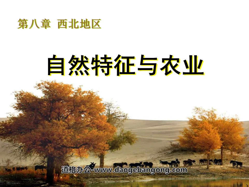
"Natural Features and Agriculture" Northwest Region PPT Courseware 3
2024-10-12
Copyright statement: This material is compiled and released by the user of Daoge Resources. The copyright belongs to the author. For commercial use, please contact the copyright owner. If there is any infringement, please contact the webmaster to remove the resource.
Download Points: 0.00
Free Download
Upgrade VIP
Favorite
Views: 1774 / Downloads: 685
Description
"Natural Features and Agriculture" Northwest Region PPT Courseware 3
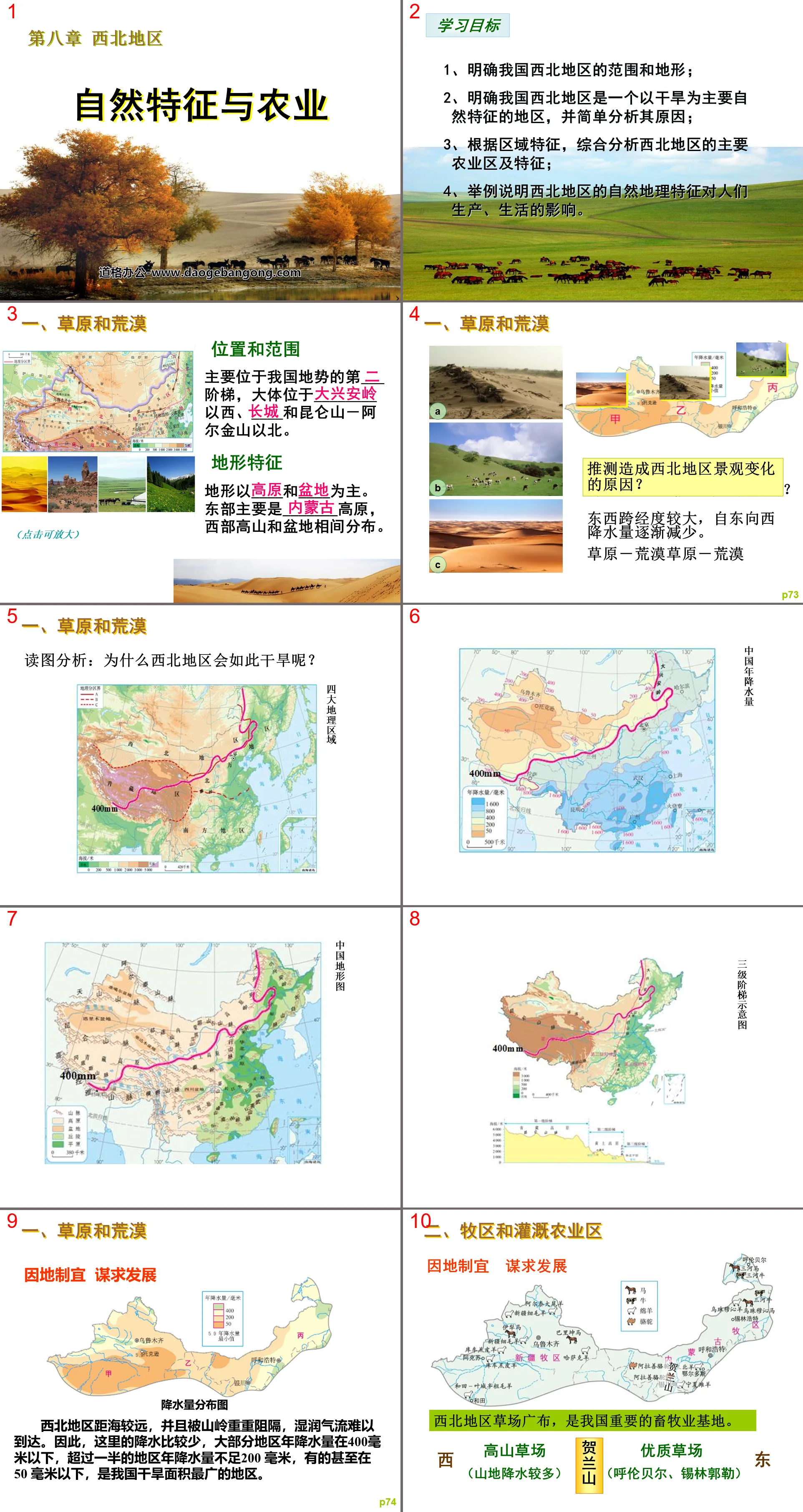
learning target
1. Clarify the scope and terrain of northwest my country;
2. Make it clear that northwest my country is a region with drought as its main natural feature, and briefly analyze its reasons;
3. Comprehensive analysis of the main agricultural areas and characteristics of the northwest region based on regional characteristics;
4. Give examples to illustrate the impact of the natural geographical features of the northwest region on people’s production and life.
1. Grasslands and deserts
location and range
It is mainly located on the ___th step of my country's terrain, generally located to the west of ________, ____ and the north of Kunlun Mountains-Altun Mountains.
terrain features
The terrain is dominated by ____ and ____. The eastern part is mainly composed of _______ plateau, and the western part has mountains and basins alternately distributed.
Speculate what caused the landscape changes in the Northwest?
Arrange the three photos A, B, and C in order from wet to dry?
The longitude between east and west is large, and the precipitation gradually decreases from east to west.
grassland-desert steppe-desert
2. Pastoral areas and irrigated agricultural areas
The northwest region has little precipitation, and agriculture is distributed in areas with river water, mountain ice and snow meltwater, and groundwater irrigation, forming irrigated agricultural areas.
Oasis (irrigated) agriculture
The inland northwest has a dry climate, less annual precipitation, and relatively large sandstorms. Water has become a key factor restricting agricultural development.
Irrigated Agriculture - "Song of the Yangtze River"
In 574 AD, 20,000 households were moved to Liziyuan (today's east of Yinchuan City) and Huaiyuan County was established. After the Northern Zhou Dynasty defeated the Southern Dynasty, they moved their people to Lingzhou (today's Lingwu City, Ningxia). Because these Jiangnan people "revere etiquette, love learning, and have similar customs", they diverted water to grow rice, plant mulberry and silkworms, plant poplars and willows, and cultivate plum trees. Peach cultivation has given Ningxia the reputation of "fortress on the south of the Yangtze River".
measure
Construction of water conservancy facilities such as diversion canals, irrigation canals, and karez wells;
Make rational use of water resources, adopt advanced irrigation technologies such as sprinkler irrigation and drip irrigation, and develop water-saving agriculture;
Return farmland to grazing and pasture, implement area-based rotational grazing, and build artificial pastures;
Protect surface vegetation and strengthen ecological environment construction.
Knowledge review
natural features
location and terrain
Climate: temperate continental
River: inland river
Natural landscape: grassland-desert steppe-desert
agriculture
Inner Mongolia pastoral areas and their excellent livestock breeds
Xinjiang pastoral areas and their excellent livestock breeds
Distribution of irrigated agricultural areas and their main agricultural products
Class exercises
1. The ground vegetation in the northwest region, from east to west, is roughly ( )
A. Desert→Desert Steppe→Grassland
B. desert → grassland → desert
C. grassland → desert → grassland
D. grassland → desert steppe → desert
2. The most direct irrigation water source in Ningxia Plain and Hetao Plain is ( )
A. River water B. Lake water c. Groundwater D. rainwater
3. Crops cannot be grown in many places in the northwest region. The main reason is ( )
A. The local temperature is too low
B. The local population is sparse and the labor force is insufficient.
C. The local annual rainfall is too little
D. Insufficient local soil fertility
4. Which of the following statements about the topographic features of the northwest region is correct ( )
A. The terrain is mainly plateaus and mountains
B. The terrain is mainly plateaus and plains
C. The terrain is dominated by plateaus and basins
D. The terrain is mainly plains and basins
Keywords: Northwest region teaching courseware, natural features and agriculture teaching courseware, New People's Education Edition eighth grade geography PPT courseware volume 2, eighth grade geography slide courseware download, northwest region PPT courseware download, natural features and agriculture PPT courseware download,. ppt format
For more information about the "Natural Features and Agriculture Northwest Region" PPT courseware, please click the "Natural Features and Agriculture ppt Northwest Region ppt" tag.
"Natural Features and Agriculture" Qinghai-Tibet Region PPT Courseware 4:
"Natural Features and Agriculture" Qinghai-Tibet Region PPT Courseware 4 1. The Roof of the World The Qinghai-Tibet region is located in the southwest of my country, west of the Hengduan Mountains, south of the Kunlun Mountains, and to the national border in the south. Topography: The northwest is high and the southeast is low plateau, with an average altitude of 4,000 meters. Qinghai-Tibet Plateau..
"Natural Features and Agriculture" Qinghai-Tibet Region PPT Courseware 3:
"Natural Features and Agriculture" Qinghai-Tibet Region PPT Courseware 3 1. The Roof of the World The Qinghai-Tibet region is located on the _____th level of terrain in my country, with an average altitude of more than _____ meters. It is called _____ and is the _____ plateau in the world. . What are the characteristics of the terrain in the Qinghai-Tibet region? Looking from afar...
"Natural Features and Agriculture" Qinghai-Tibet Region PPT Courseware 2:
"Natural Features and Agriculture" Qinghai-Tibet Region PPT Courseware 2 1. The location and scope of the Qinghai-Tibet region 2. The natural geographical features are high and cold. Causes: the Eurasian plate and the Indian Ocean plate squeeze and uplift the source of the river, and there are many lakes in the Yangtze River, Yellow River, Yarlung Zangbo River, Nujiang Snow Peaks...
File Info
Update Time: 2024-10-12
This template belongs to Geography courseware People's Education Edition Geography for Eighth Grade Volume 2 industry PPT template
"Natural Features and Agriculture" Northwest Region PPT Courseware 3 Simple campus recruitment activity planning plan summary enterprise and institution recruitment publicity lecture PPT template is a general PPT template for business post competition provided by the manuscript PPT, simple campus recruitment activity planning plan summary enterprise and institution recruitment promotion Lecture PPT template, you can edit and modify the text and pictures in the source file by downloading the source file. If you want more exquisite business PPT templates, you can come to grid resource. Doug resource PPT, massive PPT template slide material download, we only make high-quality PPT templates!
Tips: If you open the template and feel that it is not suitable for all your needs, you can search for related content "Natural Features and Agriculture" Northwest Region PPT Courseware 3 is enough.
How to use the Windows system template
Directly decompress the file and use it with office or wps
How to use the Mac system template
Directly decompress the file and use it Office or wps can be used
Related reading
For more detailed PPT-related tutorials and font tutorials, you can view: Click to see
How to create a high-quality technological sense PPT? 4 ways to share the bottom of the box
Notice
Do not download in WeChat, Zhihu, QQ, built-in browsers, please use mobile browsers to download! If you are a mobile phone user, please download it on your computer!
1. The manuscript PPT is only for study and reference, please delete it 24 hours after downloading.
2. If the resource involves your legitimate rights and interests, delete it immediately.
3. Contact information: service@daogebangong.com
"Natural Features and Agriculture" Northwest Region PPT Courseware 3, due to usage restrictions, it is only for personal study and reference use. For commercial use, please go to the relevant official website for authorization.
(Personal non-commercial use refers to the use of this font to complete the display of personal works, including but not limited to the design of personal papers, resumes, etc.)
Preview
Related Search:
"Natural Features and Agriculture" Northwest Region PPT Courseware 3
2024-10-12
Copyright statement: This material is compiled and released by the user of Daoge Resources. The copyright belongs to the author. For commercial use, please contact the copyright owner. If there is any infringement, please contact the webmaster to remove the resource.
Download Points: 0.00
Free Download
Upgrade VIP
Favorite
Views: 1774 / Downloads: 685


