The second volume of history for eighth grade compiled by the People's Education Publishing House
Zhonghua Book Company Edition Eighth Grade History Volume 2
People's Education Edition Eighth Grade History Volume 1
People's Education Press Seventh Grade History Volume 1
Zhonghua Book Company Edition Seventh Grade History Volume 2
Volume 1 of the seventh grade history compiled by the People's Education Publishing House
Yuelu Edition Seventh Grade History Volume 2
People's Education Edition History and Society 9th Grade Part II
People's Education Edition Eighth Grade History Volume 2
People's Education Press History and Society Grade 7
People's Education Press History and Society Grade 9
East China Normal University Edition Seventh Grade History Volume 1
People's Education Press Seventh Grade History Volume 2
People's Education Press History and Society for Grade 8 Volume 1
Yuelu Edition Seventh Grade History Volume 1
People's Education Press Ninth Grade History Volume 2

| Category | Format | Size |
|---|---|---|
| People's Education Press History and Society Grade 7 | pptx | 6 MB |

"Mother River" Homeland of People of All Nationalities in China PPT
2024-10-17
Copyright statement: This material is compiled and released by the user of Daoge Resources. The copyright belongs to the author. For commercial use, please contact the copyright owner. If there is any infringement, please contact the webmaster to remove the resource.
Download Points: 0.00
Free Download
Upgrade VIP
Favorite
Views: 2335 / Downloads: 849
Description
"Mother River" Homeland of People of All Nationalities in China PPT
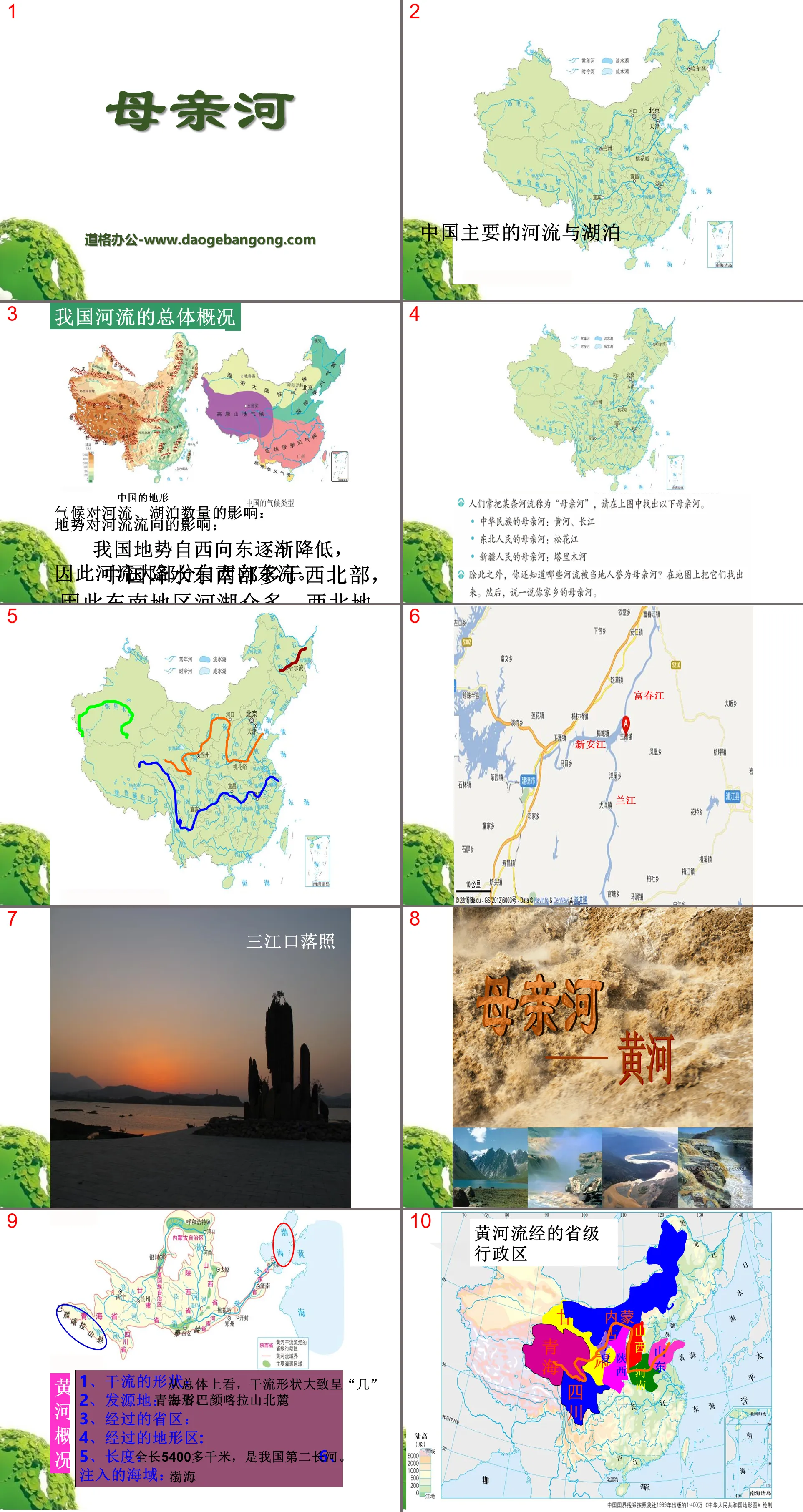
Part I: General overview of rivers in my country
Impact of climate on the number of rivers and lakes:
There is more precipitation in the southeast of China than in the northwest, so there are many rivers and lakes in the southeast, while there are fewer rivers and lakes in the northwest.
The influence of terrain on river flow:
The terrain of our country gradually decreases from west to east, so most of the rivers flow from west to east.
Mother River PPT, Part 2: Overview of the Yellow River
1. The shape of the main stream: Generally speaking, the shape of the main stream is roughly in the shape of "several".
2. Origin: North foot of Bayan Har Mountain, Qinghai Province
3. Provinces passed through:
4. Terrain area passed through:
5. Length: With a total length of more than 5,400 kilometers, it is the second longest river in my country.
6. Sea area injected: Bohai Sea
The segments, main tributaries and characteristics of each segment of the Yellow River
Upstream: large water volume, many canyons, large drops, and rich hydraulic resources;
Middle reaches: lots of sediment;
Downstream: "above ground river" (or "hanging river").
Mother River PPT, Part 3: Defending the Yellow River
We affectionately call the Yellow River the mother river. Watching our mother suffer these disasters, every descendant of the Yellow River will not remain indifferent. 163 academicians of the Chinese Academy of Sciences and the Chinese Academy of Engineering jointly issued a solemn appeal to the descendants of the Yellow River at home and abroad: Take action to save the Yellow River! Please think and discuss: What methods can we take to regulate and save the Yellow River?
1. Understand and publicize the significance of protecting the Yellow River.
2. Establish a sense of urgency, save water and protect the environment.
3. Plant trees and conserve soil and water.
4. Construction of water conservancy projects.
5. Unified control of industrial, agricultural and domestic sewage emissions.
Mother River PPT, Part 4: Test in class
1. The Yellow River is our country ( )
A.The river with the longest flow
B. The second largest river in my country
C. The second longest river in my country
D. Rivers with the largest water energy resources and sediment content
2. The following cities are located along the main stream of the Yellow River ( )
A. Zhengzhou B. Xi'an C. Taiyuan D. Shijiazhuang
3. The following tributaries of the Yellow River flow through Shanxi Province ( )
A. Fenhe B. Weihe C. Taohe D. Huangshui
4. The reason why the Yellow River basin east of Zhengzhou is particularly narrow and has no tributaries is ( )
A.Flows through plains and has an arid climate
B. The amount of irrigation water in rivers is reduced due to diversion from the Yellow River
C. Ground vegetation is scarce and evaporation is strong
D. The river bed is higher than the ground outside the embankment
Mother River PPT, Part 5: One of the Mother Rivers: the Yangtze River
Overall: Yangtze River - "V+W" shape
The Yangtze River originates from: Geladandong Snow Peak in Tanggula Mountains
The provinces and regions that the Yellow River and the Yangtze River pass through together are: Qinghai and Sichuan
The terrain area where the Yellow River and the Yangtze River flow together is: the Qinghai-Tibet Plateau
The birthplace of the Yangtze River - Geladandong Snow Peak
The landscape at the source of the Yangtze River is located on the Qinghai-Tibet Plateau, the first step in my country. This picture shows the Tuotuo River, the main source of the Yangtze River.
The Minjiang River, a tributary of the upper reaches of the Yangtze River, not only has the effect of preventing floods and disasters, but is also a wonder in the history of world water conservancy projects.
Landscape of the middle reaches of the Yangtze River. The Yangtze River is the "golden waterway" that runs from east to west in my country.
The landscape of the upper reaches of the Yangtze River is located between the first ladder and the second ladder in my country. The terrain changes greatly, and the water flows deeply into the cross-cutting mountains, forming steep and spectacular canyons.
Mother River PPT, Part Six: Characteristics of Each Section of the Yangtze River
Upstream: There are many canyons and rich water resources.
Middle reaches: The river is curved and there are many rivers and lakes. (Jiuqu ileum)
Downstream: The river is wide and the water is deep, so shipping is convenient.
The Yangtze River is my country's most important inland shipping channel and is known as the "golden waterway".
Problems facing the Yangtze River
Natural factors: Disadvantages caused by the monsoon climate and the instability of the monsoon, which may cause floods.
Human factors: The competition between humans and water for land and the wrong practices of humans occupying rivers and reclaiming lakes for farmland have greatly reduced the flood storage and diversion capabilities of rivers and lakes, and increased the possibility of serious floods in coastal areas.
Diagram of the Yangtze River Basin
Fill it out:
1. The Yangtze River originates from the ___________ Snow Peak, the main peak of the Tanggula Mountains, and flows into the ______ Sea. It is ______ kilometers long and is the ______ largest river in China.
2. The boundary between the upper and middle reaches of the Yangtze River is ______, and the boundary between the middle and lower reaches of the Yangtze River is ______.
Keywords: free download of History and Society PPT courseware for the second volume of the seventh grade of the People's Education Press, PPT download of Mother River, PPT download of the homeland of people of all ethnic groups in China, .PPT format;
For more information about the PPT courseware "Mother River, the home of the people of all ethnic groups in China", please click the "Mother River, the home of the people of all ethnic groups in China" ppt tag.
"Understanding the Treasure Island of Taiwan" The Homeland of People of All Nationalities in China PPT Courseware:
The first part of the PPT courseware "Understanding the Treasure Island of Taiwan", the home of the people of all ethnic groups in China: 1. The scope and composition of Taiwan. Taiwan Island is China's largest island, covering an area of approximately 36,000 square kilometers. Penghu Islands, Diaoyu Islands, Chiwei Island, a total of more than 80 islands and fishing islands. The island has been...
"Understanding the Treasure Island of Taiwan" Homeland of People of All Nationalities in China PPT:
"Understanding the Treasure Island of Taiwan" PPT, the homeland of the people of all ethnic groups in China. Part 1: The scope of Taiwan Province. Taiwan's land and sea location. Taiwan faces _____ to the west, _____ to the north, _____ to the east, and _____ to the south. Taiwan Island is located in the connection zone between the Eurasian continent and the Pacific Ocean. We...
"Significant Differences Between the East and the West" Homelands of People of All Nationalities in China PPT:
"The Difference Between the East and the West is Significant" The Homelands of People of All Ethnic Groups in China PPT Part One: How to divide the East and the West? Let’s talk about the provincial administrative units in the western region. Western China consists of five provinces in the southwest, five provinces in the northwest, Inner Mongolia, Guangxi and Hunan..
File Info
Update Time: 2024-10-17
This template belongs to History courseware People's Education Press History and Society Grade 7 industry PPT template
"Mother River" Homeland of People of All Nationalities in China PPT Simple campus recruitment activity planning plan summary enterprise and institution recruitment publicity lecture PPT template is a general PPT template for business post competition provided by the manuscript PPT, simple campus recruitment activity planning plan summary enterprise and institution recruitment promotion Lecture PPT template, you can edit and modify the text and pictures in the source file by downloading the source file. If you want more exquisite business PPT templates, you can come to grid resource. Doug resource PPT, massive PPT template slide material download, we only make high-quality PPT templates!
Tips: If you open the template and feel that it is not suitable for all your needs, you can search for related content "Mother River" Homeland of People of All Nationalities in China PPT is enough.
How to use the Windows system template
Directly decompress the file and use it with office or wps
How to use the Mac system template
Directly decompress the file and use it Office or wps can be used
Related reading
For more detailed PPT-related tutorials and font tutorials, you can view: Click to see
How to create a high-quality technological sense PPT? 4 ways to share the bottom of the box
Notice
Do not download in WeChat, Zhihu, QQ, built-in browsers, please use mobile browsers to download! If you are a mobile phone user, please download it on your computer!
1. The manuscript PPT is only for study and reference, please delete it 24 hours after downloading.
2. If the resource involves your legitimate rights and interests, delete it immediately.
3. Contact information: service@daogebangong.com
"Mother River" Homeland of People of All Nationalities in China PPT, due to usage restrictions, it is only for personal study and reference use. For commercial use, please go to the relevant official website for authorization.
(Personal non-commercial use refers to the use of this font to complete the display of personal works, including but not limited to the design of personal papers, resumes, etc.)
Preview
Hot Tags:
Related Search:
"Mother River" Homeland of People of All Nationalities in China PPT
2024-10-17
Copyright statement: This material is compiled and released by the user of Daoge Resources. The copyright belongs to the author. For commercial use, please contact the copyright owner. If there is any infringement, please contact the webmaster to remove the resource.
Download Points: 0.00
Free Download
Upgrade VIP
Favorite
Views: 2335 / Downloads: 849


