Business Planet Edition 7th Grade Geography Volume 2
People's Education Edition Geography for Seventh Grade Volume 2
Business Planet Edition 7th Grade Geography Volume 1
Business Planet Edition Geography for Grade 8 Volume 1
Shanghai Education Edition Seventh Grade Geography Volume 1
Business Planet Edition Geography for Eighth Grade Volume 2
Hunan Education Edition High School Geography Compulsory Course I
People's Education Edition Geography for Grade 7 Volume 1
Shanghai Education Edition Geography for Sixth Graders Volume 1
Lu Ke version of high school geography compulsory course I
People's Education Edition Geography for Eighth Grade Volume 2
Shanghai Education Edition Seventh Grade Geography Volume 2
Shanghai Education Edition Geography for Sixth Graders Volume 2
People's Education Press High School Geography Compulsory Course 1
Compulsory Course 1 of High School Geography in China Graphics Edition
Hunan Education Edition High School Geography Compulsory Course II

| Category | Format | Size |
|---|---|---|
| People's Education Press High School Geography Compulsory Course 1 | pptx | 6 MB |

"Meteorological Disasters" Natural Disasters PPT
2024-09-09
Copyright statement: This material is compiled and released by the user of Daoge Resources. The copyright belongs to the author. For commercial use, please contact the copyright owner. If there is any infringement, please contact the webmaster to remove the resource.
Download Points: 0.00
Free Download
Upgrade VIP
Favorite
Views: 3580 / Downloads: 850
Description
"Meteorological Disasters" Natural Disasters PPT
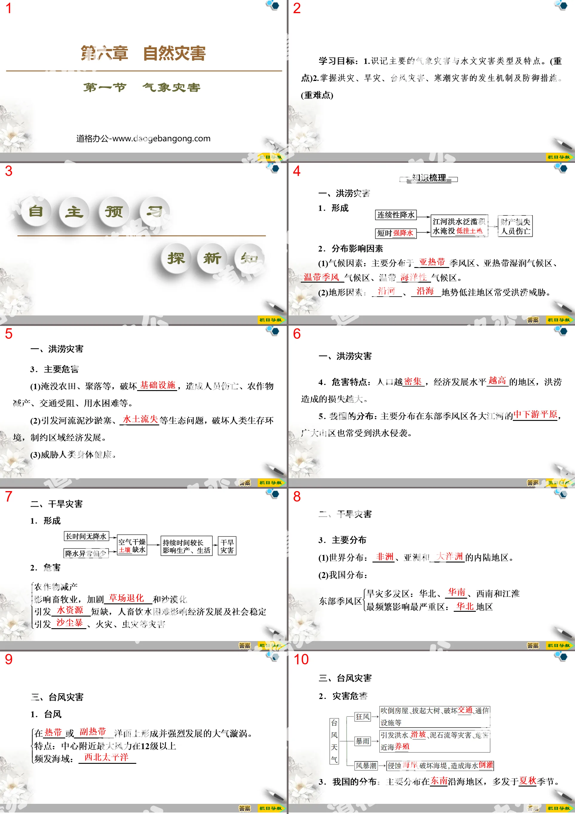
Part One Content: Learning Objectives:
1. Understand the main types and characteristics of meteorological disasters and hydrological disasters. (emphasis)
2. Understand the occurrence mechanisms and defensive measures of floods, droughts, typhoons, and cold wave disasters. (important and difficult points)
Meteorological disaster PPT, part 2: independent preview to explore new knowledge
1. Flood disasters
1. form
2. Distribution influencing factors
(1) Climatic factors: Mainly distributed in _____ monsoon zone, subtropical humid climate zone, __________ climate zone, temperate _____ climate zone.
(2) Topographic factors: _____, _____ low-lying areas are often threatened by floods.
3. Main hazards
(1) Submerge farmland, settlements, etc., destroy _____, cause casualties, crop yield reduction, traffic obstruction, water difficulties, etc.
(2) It causes ecological problems such as river sedimentation and _____, destroys the human living environment and restricts regional economic development.
(3) Threaten human health.
4. Hazard characteristics: The more _____ the population and the _____ level of economic development, the greater the losses caused by floods.
5. Distribution in my country: It is mainly distributed in the _____ of major rivers in the eastern monsoon region, and the vast mountainous areas are also often affected by floods.
2. Drought disaster
1. form
2. harm
crop yield reduction
Affect animal husbandry, aggravate___________ and desertification
Causes shortage of _____, making drinking water difficult for humans and animals, affecting economic development and social stability
Causing disasters such as _____, fires, and insect infestations
3. Main distribution
(1) World distribution: _____, Asia and the inland areas of _____.
(2) Distribution in my country:
Eastern monsoon zone
Drought-prone areas: North China, _____, Southwest and Jianghuai
The most frequently affected area: _____ area
Meteorological Disasters PPT, Part 3: Collaboration to explore and overcome difficult problems
Floods
Legend has it that during the reign of Emperor Yao, floods often occurred in the Yellow River Basin. In order to stop flooding and protect agricultural production, Emperor Yao convened a meeting of tribal leaders to recruit experts in flood control to quell flood damage. Gun was recommended for the job. After Gun accepted the task, he used embankments to block the water and built the city of Sanren. He used simple embankments to surround the residential area to block the flood. He failed for nine years and was eventually exiled to Yushan and died. After Emperor Shun succeeded to the throne, he appointed Gun's son Yu to control the floods. Yu summarized his father's experience in water control and changed Gun's "containment and obstruction" method to "drainage and stagnation", which was to use the natural tendency of water to flow from high to low and follow the terrain to clear the blocked river flow. The floodwaters are introduced into dredged rivers, depressions or lakes, and then connected to the sea, thereby calming the floods. Later, Yu became the first king of the Xia Dynasty and was known as "Shen Yu" and was praised by later generations.
Question 1 (Regional Cognition) What are the main natural causes of floods in the middle and lower reaches of the Yellow River?
Tip: The middle and lower reaches of the Yellow River have a temperate monsoon climate, with concentrated rainfall and heavy rains in summer. The terrain in the middle and lower reaches is relatively flat, and slowing down of the river flow is prone to flooding.
Question 2 (Comprehensive thinking) In the past, to control floods, Gun adopted the method of "building embankments to block water" and Yu adopted the method of "draining and guiding stagnation". I would like to ask, is the method of "dredging and guiding stagnation" necessarily more effective than the method of "building embankments to block water"?
Tip: Not necessarily. Flood management should be based on local conditions, comprehensive management, and a combination of engineering measures and non-engineering measures.
Question 3 (Comprehensive thinking) How has the Yellow River, Haihe River, and Huaihe River been comprehensively regulated since the founding of New China? Summarize the prevention and control models of large rivers.
Tip: Build a reservoir in the upper reaches of the Yellow River, control soil erosion in the middle reaches, dredge the river channels and strengthen embankments in the lower reaches; build reservoirs in the upper reaches of the major tributaries of the Hai River and Huaihe River, build flood storage projects in the depressions in the middle reaches, and dig new rivers into the sea in the lower reaches to disperse the water flow. Prevention and control model: build reservoirs in the upper reaches, regulate rivers in the middle and lower reaches, strengthen embankments, open flood diversion areas, and adjust and expand flood outlets.
Meteorological Disaster PPT, Part 4: Competing Literacy Standards and Solidifying Basics
1. Among the natural disasters in my country, the most common ones with a wide range of hazards are ()
A. Drought and earthquakes B. Typhoons and landslides
C. Floods and droughts D. Mudslides and Cold Waves
C. Due to the wide range of influence of my country's monsoon climate, affected by the monsoon climate, seasonal changes in precipitation, and large inter-annual changes, drought and flood disasters are the most common natural disasters that affect our country and have a wide range of hazards. ]
2. Cold wave is a common weather in our country, which can directly cause ()
①Perennial drought in the northwest region ②Spring floods in the northeastern region
③Wind and snow in the Huanghuai area ④Freezing rain and snow in the Jiangnan area
A. ①② B. ②③
C. ③④ D. ①④
C. A cold wave is a natural disaster in which cold air moves south quickly, causing a substantial cooling. It is mainly characterized by strong winds, frost, rain and snow, ③④ right. The perennial drought in the northwest is because water vapor is difficult to reach deep inside the continent, ① False; the spring floods in the Northeast are caused by the melting of ice and snow, ② False. ]
3. Considering both climate and agricultural production, the area with the most severe spring drought in my country is ()
A. Northeastern region B. North-west region
C. Jianghuai area D. North China
D. In spring, my country's climate becomes warmer, the temperature rises, and evaporation increases greatly; crops also begin to turn green and require large amounts of water. The sparse precipitation in spring in North China has aggravated the spring drought in North China. There is a saying that "spring rain is as expensive as oil". The spring snow in the Northeast has melted, easing the spring drought in the Northeast. The northwest region has a temperate continental climate with scant precipitation, and spring drought is not the most serious. In the Jianghuai region, surface water is abundant and agricultural irrigation is convenient. ]
Keywords: Free download of PPT courseware for high school geography compulsory course 1 of the People's Education Press, meteorological disaster PPT download, natural disaster PPT download, .PPT format;
For more information about the "Natural Disasters and Meteorological Disasters" PPT courseware, please click on the "Natural Disasters ppt Meteorological Disasters ppt" tag.
"Application of Geographic Information Technology in Disaster Prevention and Mitigation" Natural Disaster PPT Courseware:
"Application of Geographic Information Technology in Disaster Prevention and Mitigation" Natural Disasters PPT Courseware Part One: Course Standard Explanation 1. Understand the working principles of remote sensing technology, global satellite navigation systems and geographic information systems, and master their characteristics. 2. Give examples of remote sensing technology, global satellite...
"Application of Geographic Information Technology in Disaster Prevention and Mitigation" Natural Disasters PPT:
"Application of Geographic Information Technology in Disaster Prevention and Mitigation" Natural Disasters PPT Part One Content: Learning Objectives: 1. Understand the main types and characteristics of geographic information technology. 2. Master the working principles of major geographical information technologies and their applications in disaster prevention and reduction. ... ...
"Disaster Prevention and Mitigation" Natural Disaster PPT Courseware:
"Disaster Prevention and Mitigation" Natural Disasters PPT Courseware Part One: Learning Objectives: 1. Understand the main means of disaster prevention and mitigation. (Key points) 2. Master the main measures for disaster prevention and reduction. (Key points) 3. Master the basic methods of self-rescue and mutual rescue in disasters. (Key point) ... ... ....
File Info
Update Time: 2024-09-09
This template belongs to Geography courseware People's Education Press High School Geography Compulsory Course 1 industry PPT template
"Meteorological Disasters" Natural Disasters PPT Simple campus recruitment activity planning plan summary enterprise and institution recruitment publicity lecture PPT template is a general PPT template for business post competition provided by the manuscript PPT, simple campus recruitment activity planning plan summary enterprise and institution recruitment promotion Lecture PPT template, you can edit and modify the text and pictures in the source file by downloading the source file. If you want more exquisite business PPT templates, you can come to grid resource. Doug resource PPT, massive PPT template slide material download, we only make high-quality PPT templates!
Tips: If you open the template and feel that it is not suitable for all your needs, you can search for related content "Meteorological Disasters" Natural Disasters PPT is enough.
How to use the Windows system template
Directly decompress the file and use it with office or wps
How to use the Mac system template
Directly decompress the file and use it Office or wps can be used
Related reading
For more detailed PPT-related tutorials and font tutorials, you can view: Click to see
How to create a high-quality technological sense PPT? 4 ways to share the bottom of the box
Notice
Do not download in WeChat, Zhihu, QQ, built-in browsers, please use mobile browsers to download! If you are a mobile phone user, please download it on your computer!
1. The manuscript PPT is only for study and reference, please delete it 24 hours after downloading.
2. If the resource involves your legitimate rights and interests, delete it immediately.
3. Contact information: service@daogebangong.com
"Meteorological Disasters" Natural Disasters PPT, due to usage restrictions, it is only for personal study and reference use. For commercial use, please go to the relevant official website for authorization.
(Personal non-commercial use refers to the use of this font to complete the display of personal works, including but not limited to the design of personal papers, resumes, etc.)
Preview
Related Search:
"Meteorological Disasters" Natural Disasters PPT
2024-09-09
Copyright statement: This material is compiled and released by the user of Daoge Resources. The copyright belongs to the author. For commercial use, please contact the copyright owner. If there is any infringement, please contact the webmaster to remove the resource.
Download Points: 0.00
Free Download
Upgrade VIP
Favorite
Views: 3580 / Downloads: 850


