Business Planet Edition 7th Grade Geography Volume 1
Business Planet Edition 7th Grade Geography Volume 2
People's Education Edition Geography for Seventh Grade Volume 2
Business Planet Edition Geography for Grade 8 Volume 1
Shanghai Education Edition Seventh Grade Geography Volume 1
People's Education Edition Geography for Eighth Grade Volume 2
Hunan Education Edition High School Geography Compulsory Course I
People's Education Edition Geography for Grade 7 Volume 1
Business Planet Edition Geography for Eighth Grade Volume 2
Shanghai Education Edition Geography for Sixth Graders Volume 1
Compulsory Course 1 of High School Geography in China Graphics Edition
People's Education Edition Geography for Grade 8 Volume 1
Hunan Education Edition High School Geography Compulsory Course II
Lu Ke version of high school geography compulsory course I
Shanghai Education Edition Seventh Grade Geography Volume 2
People's Education Press High School Geography Compulsory Course 1

| Category | Format | Size |
|---|---|---|
| Business Planet Edition 7th Grade Geography Volume 1 | pptx | 6 MB |

"Globe and Latitude and Latitude" PPT
2024-10-19
Copyright statement: This material is compiled and released by the user of Daoge Resources. The copyright belongs to the author. For commercial use, please contact the copyright owner. If there is any infringement, please contact the webmaster to remove the resource.
Download Points: 0.00
Free Download
Upgrade VIP
Favorite
Views: 3589 / Downloads: 566
Description
"Globe and Latitude and Latitude" PPT
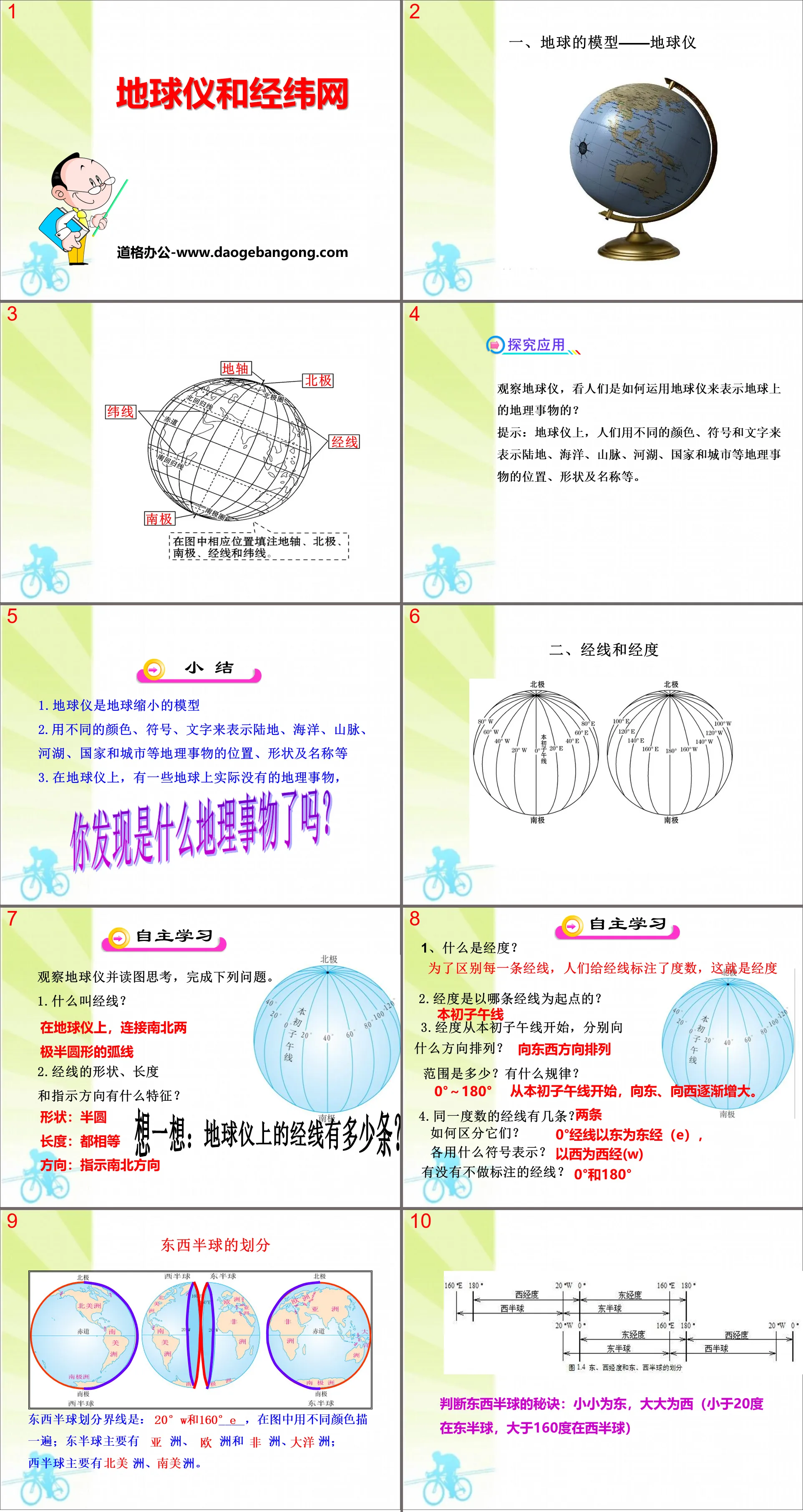
Part One: Model of the Earth—Globe
Explore applications
Observe the globe and see how people use it to represent geographical things on the earth?
Tip: On the globe, people use different colors, symbols and words to represent the location, shape and name of geographical things such as land, oceans, mountains, rivers and lakes, countries and cities.
summary
1. A globe is a reduced model of the Earth
2. Use different colors, symbols, and words to represent the location, shape, and name of geographical objects such as land, oceans, mountains, rivers, lakes, countries, and cities, etc.
3. On the globe, there are some geographical things that are not actually on the earth.
Globe and latitude and longitude network PPT, part 2 content: longitude and longitude
Self-learning
Observe the globe, read and think about the picture, and complete the following questions.
1.What is a meridian?
On a globe, the semicircular arc connecting the north and south poles
2. What are the characteristics of the shape, length and indicated direction of the meridian?
Shape: semicircle
Length: all equal
Direction: Indicates north-south direction
1. What is longitude?
In order to distinguish each meridian, people marked the meridian with degrees. This is longitude.
2. Which meridian does longitude start from?
prime meridian
3. Starting from the prime meridian, in what directions are the longitudes arranged?
Arranged in east-west direction
What is the range? What are the rules?
0°~180° Starting from the prime meridian, it gradually increases eastward and westward.
Globe and latitude and longitude network PPT, the third part: lines of latitude and latitude
collaborative inquiry
1.What is latitude?
2. Is the latitude line a circle or a semicircle?
What direction do parallel lines indicate?
Are the lengths of the parallels equal?
3. Which is the longest parallel?
What is the pattern of changes in the length of latitude lines?
gradually shortens from the equator to the poles
4. How many lines of latitude are there on the globe?
Countless
Globe and Latitude and Latitude PPT, Part 4: Exploration and Application
1. The maximum latitude is _____, and there are _____ lines of latitude.
2. The smaller the latitude, the latitude line _____; the larger the latitude, the latitude line _____.
3. If you walk straight ahead along a certain latitude, can you return to the starting point without changing the direction?
able. Parallels of latitude are circles that circle the earth in the east-west direction. If you keep moving forward along a certain latitude, you can return to the starting point.
4.The dividing line between the northern and southern hemispheres is _____. Does northern latitude have to be in the northern hemisphere, and southern latitude has to be in the southern hemisphere?
Tip: Yes. The equator is the dividing line between north and south latitudes, and the dividing line between the northern and southern hemispheres, so northern latitude (N) must be in the northern hemisphere, and southern latitude (S) must be in the southern hemisphere.
[Student Assistance Weibo] Interpretation of North and South Latitude and East and West Longitude
(1) If there is an equator (0° latitude) in the label, then north of the equator is north latitude (N) and south of the equator is south latitude (S).
(2) If the equator (0° latitude) does not appear in the label, the value increases north to north latitude (N) and south to south latitude (S).
(3) If there is a 0° longitude in the label, then the east longitude (E) of the 0° longitude is the east longitude (E), and the west longitude (W) is the west longitude.
(4) If the 0° longitude does not appear in the label, the value increases eastward to east longitude (E) and westward to west longitude (W).
Globe and latitude and longitude PPT, part 5: compliance test
1. There are many points and lines on the globe, and the equator belongs to ( )
A.Longitude B.Latitude C.Tropic of Cancer D.Meridian
2. Which of the following lines indicates the north-south direction ( )
A. Prime meridian B. Equator
C. Tropic of Cancer D. Antarctic Circle
3. People often use the letters "E" and "N" to represent ( )
A.Eastern longitude and northern latitude B.Eastern longitude and southern latitude
C. West longitude and north latitude D. West longitude and south latitude
4. Beijing (116°E, 40°N) is located in ( )
A. Northern Hemisphere, Eastern Hemisphere B. Southern Hemisphere, Western Hemisphere
C. Northern Hemisphere, Western Hemisphere D. Southern Hemisphere, Eastern Hemisphere
5. The meridian line dividing the eastern and western hemispheres is ( )
A.0° and 180° warp coils B.Any warp coil
C.20°E and 160°W warp coil D.20°W and 160°E warp coil
Globe and latitude and longitude PPT, part 6 content: [Judgment and Answer]
1. The view that "the sky is round like a cover and the place is like a chess game" is correct. ( )
Tip: Due to the limited scope of activities, ancient people believed that the earth was flat, and regarded the sky as a huge upside-down pot, which led to the erroneous view that "the sky is round like a cover, and the place is like a chess game."
2. Columbus’s voyage around the world first confirmed that the earth is a sphere. ( )
Tip: Magellan’s fleet circumnavigated the globe and was the first to prove that the Earth is a sphere.
3. The maximum circumference of the Earth is about 40,000 meters. ( )
Tip: The maximum circumference of the Earth is about 40,000 kilometers.
4. A globe is a reduced model of the real earth. ( )
Tip: A globe is a model made after the shape of the earth and is not exactly the same as the real earth.
5. The earth’s axis does not really exist, it is an imaginary axis. ( )
Tip: The Earth's axis on a globe does not exist on Earth.
Keywords: Business Planet edition seventh grade geography PPT courseware free download, globe and graticule PPT download, .PPT format;
For more information about the PPT courseware "The Globe and the Graticulus and Latitudes", please click the "Globe and the Graticulus and Latitudes" ppt tab.
"Globe and Latitude and Latitude" PPT download:
"Globe and Latitude and Latitude Network" PPT Download Part One Content: Introduction of New Lesson Maritime Search and Rescue A seagoing ship was in distress in the ocean, sent an emergency call for help, and reported its specific location: 13703 East Longitude, 3349 minutes North Latitude. The rescue boat received the distress signal and moved quickly...
"Globe and Latitude and Latitude" PPT courseware:
"Globe and Latitude and Latitude" PPT courseware Part One: Model Globe of the Earth What is the difference between a globe and the earth? In order to facilitate understanding of the earth, people imitated the shape of the earth and reduced it to a certain proportion to make a model globe of the earth. Please say...
File Info
Update Time: 2024-10-19
This template belongs to Geography courseware Business Planet Edition 7th Grade Geography Volume 1 industry PPT template
"Globe and Latitude and Latitude" PPT Simple campus recruitment activity planning plan summary enterprise and institution recruitment publicity lecture PPT template is a general PPT template for business post competition provided by the manuscript PPT, simple campus recruitment activity planning plan summary enterprise and institution recruitment promotion Lecture PPT template, you can edit and modify the text and pictures in the source file by downloading the source file. If you want more exquisite business PPT templates, you can come to grid resource. Doug resource PPT, massive PPT template slide material download, we only make high-quality PPT templates!
Tips: If you open the template and feel that it is not suitable for all your needs, you can search for related content "Globe and Latitude and Latitude" PPT is enough.
How to use the Windows system template
Directly decompress the file and use it with office or wps
How to use the Mac system template
Directly decompress the file and use it Office or wps can be used
Related reading
For more detailed PPT-related tutorials and font tutorials, you can view: Click to see
How to create a high-quality technological sense PPT? 4 ways to share the bottom of the box
Notice
Do not download in WeChat, Zhihu, QQ, built-in browsers, please use mobile browsers to download! If you are a mobile phone user, please download it on your computer!
1. The manuscript PPT is only for study and reference, please delete it 24 hours after downloading.
2. If the resource involves your legitimate rights and interests, delete it immediately.
3. Contact information: service@daogebangong.com
"Globe and Latitude and Latitude" PPT, due to usage restrictions, it is only for personal study and reference use. For commercial use, please go to the relevant official website for authorization.
(Personal non-commercial use refers to the use of this font to complete the display of personal works, including but not limited to the design of personal papers, resumes, etc.)
Preview
Related Search:
"Globe and Latitude and Latitude" PPT
2024-10-19
Copyright statement: This material is compiled and released by the user of Daoge Resources. The copyright belongs to the author. For commercial use, please contact the copyright owner. If there is any infringement, please contact the webmaster to remove the resource.
Download Points: 0.00
Free Download
Upgrade VIP
Favorite
Views: 3589 / Downloads: 566


