"A Model of Urban Planning - Brasilia" Civilization Center - Urban PPT Courseware Simple campus recruitment activity planning plan summary enterprise and institution recruitment publicity lecture PPT template is a general PPT template for business post competition provided by the manuscript PPT, simple campus recruitment activity planning plan summary enterprise and institution recruitment promotion Lecture PPT template, you can edit and modify the text and pictures in the source file by downloading the source file. If you want more exquisite business PPT templates, you can come to grid resource. Doug resource PPT, massive PPT template slide material download, we only make high-quality PPT templates!
| 文件名 如何下载使用 | 下载次数 | Download Points | 下载地址 |
|---|---|---|---|
| "A Model of Urban Planni... | 11500次 | 0.00 | Free Download |
Tips: If you open the template and feel that it is not suitable for all your needs, you can search for related content "A Model of Urban Planning - Brasilia" Civilization Center - Urban PPT Courseware is enough.
How to use the Windows system template
Directly decompress the file and use it with office or wps
How to use the Mac system template
Directly decompress the file and use it Office or wps can be used
Related reading
For more detailed PPT-related tutorials and font tutorials, you can view: Click to see
How to create a high-quality technological sense PPT? 4 ways to share the bottom of the box
Notice
Do not download in WeChat, Zhihu, QQ, built-in browsers, please use mobile browsers to download! If you are a mobile phone user, please download it on your computer!
1. The manuscript PPT is only for study and reference, please delete it 24 hours after downloading.
2. If the resource involves your legitimate rights and interests, delete it immediately.
3. Contact information: service@daogebangong.com
"A Model of Urban Planning - Brasilia" Civilization Center - Urban PPT Courseware, due to usage restrictions, it is only for personal study and reference use. For commercial use, please go to the relevant official website for authorization.
(Personal non-commercial use refers to the use of this font to complete the display of personal works, including but not limited to the design of personal papers, resumes, etc.)

Related reading
For more detailed PPT-related tutorials and font tutorials, you can view:Please click to see


Authoritative PPT Summary
"A Model of Urban Planning—Brasilia" Civilization Center—Urban PPT Courseware
Part 1: Step-by-step learning
1. The location of Brazil
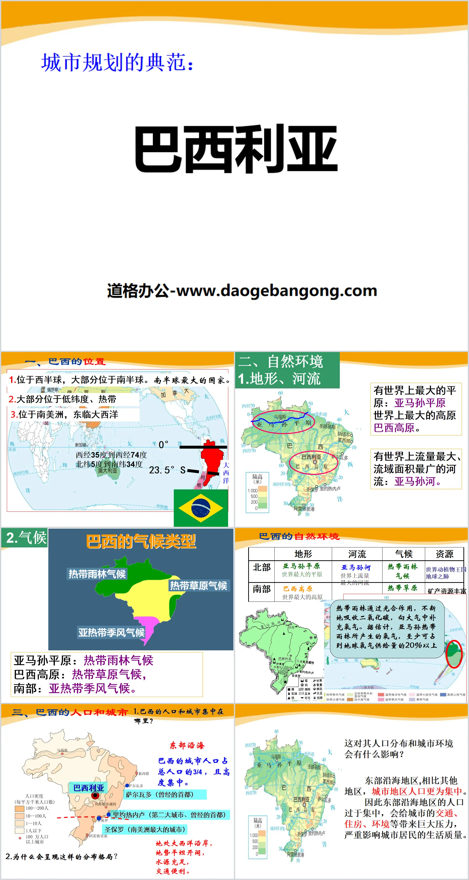
1. Located in the Western Hemisphere, mostly in the Southern Hemisphere. The largest country in the southern hemisphere.
2. Most of them are located in low latitudes and tropics
3. Located in South America, facing the Atlantic Ocean to the east
2. Natural environment
1.Topography, rivers
There is the largest plain in the world: the Amazon Plain, and the largest plateau in the world: the Brazilian Plateau.
There is the river with the largest flow and the widest drainage area in the world: the Amazon River.
2.Climate
Amazon Plains: Tropical Rainforest Climate
Brazilian Plateau: Savannah climate,
South: subtropical monsoon climate.
3. Brazil’s population and cities
1. Where is Brazil’s population and cities concentrated?
eastern coast
Brazil's urban population accounts for 3/4 of the total population and is highly concentrated.
2. Why is there such a distribution pattern?
Located on the coast of the Atlantic Ocean, the terrain is flat and open, with abundant water resources and convenient transportation.
What impact will this have on its population distribution and urban environment?
In the eastern coastal region, the population in urban areas is more concentrated than in other regions.
Therefore, the excessive concentration of population in the eastern coastal areas will bring huge pressure on urban transportation, housing, environment, etc., and seriously affect the quality of life of urban residents.
Brasilia PPT, a model of urban planning, part 2: Capital
Moving the capital
Read page 107 of the textbook and think: Why did the Brazilian government move the capital from Rio de Janeiro to Brasilia?
Dingdu Chapter
Why did the Brazilian government move the capital from Rio de Janeiro to Brasilia?
1. Rio de Janeiro’s “urban diseases” are serious; (large population, traffic jams, difficulty in employment, poor environment, difficulty in housing...)
2. Brasilia is located on the Brazilian Plateau, with high terrain, cool climate, and suitable for human habitation;
3. Relocating the capital can strengthen the management and development of the vast inland and promote the development of the inland. It can also relieve the pressure on the eastern coastal cities.
Moved the capital to Brasilia
Politics: Strengthening the management of the vast inland areas
Economy: Strengthen the development of the vast inland areas while easing the pressure on eastern coastal cities
National security: Rio de Janeiro is a coastal city that is prone to attack and unsafe.
Brasilia PPT, a model of urban planning, part 3: after-class exercises
1. The name of the Square of the Three Powers is related to Montesquieu, a famous thinker in the French Enlightenment in the 18th century. He proposed the separation of powers, namely ________, ________, and ________, which were intended to ensure freedom.
2. The largest country in South America is ________. Its capital, ________, is currently the only modern city in the world listed as a World ________ Heritage by UNESCO. It is located on ________ in central Brazil.
3. Brazil has the largest plateau in the world - ________, the largest plain in the world ________, and the river with the largest flow in the world ________.
4. Historically, Brazil has established its capital in two coastal cities, ________ and ________. Around 1950, ________ became the political, economic, and cultural center of Brazil. Later, due to the severe "urban disease" the city suffered from, the government decided to move the capital in the mid-20th century.
5. Since the equator crosses northern Brazil and the Tropic of Capricorn crosses southern Brazil, most of Brazil is located in ( )
A, high latitude B, middle latitude C, low latitude D, middle and low latitude
6. The largest country in South America is ( )
A. Brazil B. Argentina C. United States D. Chile
7. Which terrain area is Brasilia located in ( )
A. Amazon Plain B. Congo Basin
C. Brazilian plateau D. Pampas grassland
Keywords: free download of the History and Society PPT courseware for the seventh grade of the People's Education Press, PPT download of the civilized central city, PPT download of Brasilia, a model of urban planning, in .PPT format;
For more information about the PPT courseware "Brasilia, a model of urban planning in a civilized central city", please click on the Brasilia PPT tag, a model of urban planning in a civilized central city.
"How to Understand the City - Taking Moscow as an Example" Civilization Center - City PPT Courseware:
"How to Understand the City - Taking Moscow as an Example" Civilized Central City PPT Courseware Part One: Describe the location and environment of the city. Read textbook P110 and answer the question: What are the main factors that determine the initial formation of a city? 1) Defense, transportation A. Defense: River..
"How to Understand the City - Taking Moscow as an Example" Civilization Center - City PPT:
"How to Know a City - Taking Moscow as an Example" Civilized Central City PPT Part One Content: Russia's geographical location Russia, Europe, Asia (a traditional European country) The Northern Hemisphere and the Eastern Hemisphere are bordered by the Arctic Ocean in the north. Russia: Spanning the two continents of Europe and Asia, the territory 1..
"Model of Urban Planning - Brasilia" Civilization Center - City PPT:
"Brasilia, a Model of Urban Planning" Civilized Central City PPT Part One: Brazil's position on the earth Area: 8.5149 million square kilometers Population: 191 million. Caucasians account for 53.74%, mulattoes account for 38.45%, blacks account for 6.21%, yellow and...