Business Planet Edition 7th Grade Geography Volume 2
Business Planet Edition 7th Grade Geography Volume 1
Business Planet Edition Geography for Grade 8 Volume 1
People's Education Edition Geography for Seventh Grade Volume 2
Shanghai Education Edition Seventh Grade Geography Volume 1
Hunan Education Edition High School Geography Compulsory Course I
Business Planet Edition Geography for Eighth Grade Volume 2
Shanghai Education Edition Geography for Sixth Graders Volume 1
People's Education Edition Geography for Grade 7 Volume 1
People's Education Edition Geography for Eighth Grade Volume 2
Lu Ke version of high school geography compulsory course I
Hunan Education Edition High School Geography Compulsory Course II
People's Education Edition Geography for Grade 8 Volume 1
Shanghai Education Edition Seventh Grade Geography Volume 2
Shanghai Education Edition Geography for Sixth Graders Volume 2
Compulsory Course 1 of High School Geography in China Graphics Edition
| Category | Format | Size |
|---|---|---|
| Compulsory Course 2 of High School Geography in China Graphics Edition | pptx | 6 MB |

"The Geographic Background of the Coordinated Development of Beijing, Tianjin and Hebei" PPT Courseware on Land Development and Protection
2024-10-05
Copyright statement: This material is compiled and released by the user of Daoge Resources. The copyright belongs to the author. For commercial use, please contact the copyright owner. If there is any infringement, please contact the webmaster to remove the resource.
Download Points: 0.00
Free Download
Upgrade VIP
Favorite
Views: 3077 / Downloads: 359
Description
"The Geographic Background of the Coordinated Development of Beijing, Tianjin and Hebei" PPT Courseware on Land Development and Protection
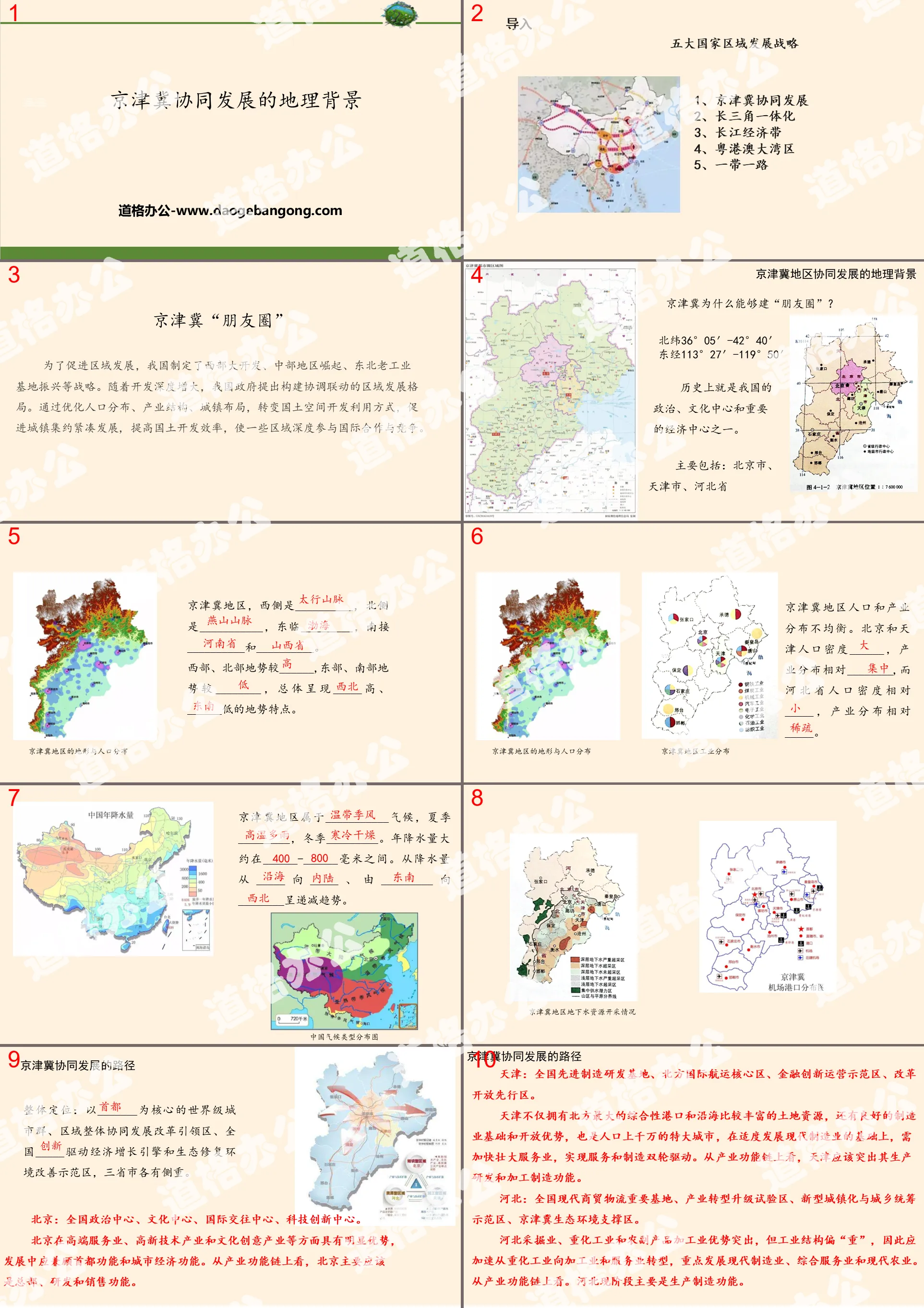
Part One: Import
Five major national and regional development strategies
1. Coordinated development of Beijing, Tianjin and Hebei
2. Integration of the Yangtze River Delta
3. Yangtze River Economic Belt
4. Guangdong-Hong Kong-Macao Greater Bay Area
5. One Belt, One Road
PPT on the geographical background of the coordinated development of Beijing-Tianjin-Hebei, part 2: Beijing-Tianjin-Hebei "circle of friends"
In order to promote regional development, my country has formulated strategies such as the development of the western region, the rise of the central region, and the revitalization of the old industrial bases in the Northeast. As the depth of development increases, the Chinese government proposes to build a coordinated and interconnected regional development pattern. By optimizing population distribution, industrial structure, and urban layout, we will transform the way land space is developed and utilized, promote intensive and compact urban development, improve land development efficiency, and enable some regions to deeply participate in international cooperation and competition.
The geographical background of coordinated development in the Beijing-Tianjin-Hebei region
Why can Beijing, Tianjin and Hebei build a "circle of friends"?
Historically, it has been one of the political and cultural centers and important economic centers of our country.
Mainly including: Beijing City, Tianjin City, Hebei Province
The Beijing-Tianjin-Hebei region is bounded by __________ to the west, ___________ to the north, _________ to the east, and __________ and __________ to the south.
The terrain in the west and north is higher than ______, while the terrain in the east and south is higher at ______. The overall terrain features higher _____ and lower ______.
The distribution of population and industry in the Beijing-Tianjin-Hebei region is uneven. The population density of Beijing and Tianjin is ______, and their industrial distribution is relatively ________, while the population density of Hebei Province is relatively _____, and their industrial distribution is relatively _____.
The Beijing-Tianjin-Hebei region has a ___________ climate, with _________ in summer and _________ in winter. Annual precipitation is approximately ______-______ mm. The precipitation shows a decreasing trend from _____ to _____ and from ________ to ________.
The path for coordinated development of Beijing, Tianjin and Hebei
Overall positioning: a world-class urban agglomeration with _______ as the core, a leading area for regional overall coordinated development and reform, a national _____-driven economic growth engine, and an ecological restoration and environmental improvement demonstration area. Each of the three provinces and cities has its own focus.
Beijing: National political center, cultural center, international exchange center, and scientific and technological innovation center.
Beijing has obvious advantages in high-end service industries, high-tech industries and cultural and creative industries, and its development should take into account both the capital function and the city's economic function. From the perspective of the industrial function chain, Beijing should mainly have headquarters, R&D and sales functions.
The path for coordinated development of Beijing, Tianjin and Hebei
Tianjin: National advanced manufacturing R&D base, northern international shipping core area, financial innovation operation demonstration area, and reform and opening up pioneer area.
Tianjin not only has the largest comprehensive port in the north and relatively abundant land resources along the coast, but also has a good manufacturing foundation and openness advantages. It is also a megacity with a population of tens of millions. On the basis of moderate development of modern manufacturing, Tianjin needs to accelerate its growth. The service industry realizes the two-wheel drive of service and manufacturing. From the perspective of the industrial function chain, Tianjin should highlight its production, research and development and processing and manufacturing functions.
Hebei: an important national base for modern commerce and logistics, a pilot area for industrial transformation and upgrading, a new urbanization and urban-rural coordination demonstration area, and a Beijing-Tianjin-Hebei ecological environment support area.
Hebei's mining industry, heavy chemical industry and agricultural and sideline products processing industry have outstanding advantages, but the industrial structure is "heavy". Therefore, the transformation from heavy chemical industry to processing industry and service industry should be accelerated, focusing on the development of modern manufacturing, comprehensive service industry and modern agriculture. From the perspective of the industrial function chain. At this stage, Hebei mainly has production and manufacturing functions.
Discussion: Why has the integration of ecological and environmental protection become one of the main paths for the coordinated development of Beijing, Tianjin and Hebei?
First, ecological and environmental problems are bound to be cross-border, such as air pollution, which is not restricted by administrative divisions. It is difficult for any place to solve it alone. It requires unified planning, unified construction, and unified supervision.
Second, ecological and environmental protection is the external motivation that “forces” the coordinated development and green development of Beijing, Tianjin and Hebei. Ecological and environmental problems have reached a point where they cannot be solved without solutions. Beijing is the capital of China, and ecological and environmental problems have affected the normal functioning of the capital.
Third, the essence of ecological integration is to reflect social equity. Each area has different main functions. In order to provide clean water sources for Beijing and Tianjin, some areas in Hebei cannot introduce industrial projects that may cause environmental pollution, nor can they apply chemical fertilizers and pesticides indiscriminately. These areas have green waters and green mountains, but are very poor. Therefore, co-construction and sharing must be achieved through ecological integration. The ability of each place to create wealth is different. We need to allow qualified areas to develop as quickly as possible, and then through ecological compensation mechanisms such as fiscal transfer payments, ecologically guaranteed areas can obtain capital for local development.
PPT on the geographical background of the coordinated development of Beijing, Tianjin and Hebei, part three: classroom testing
Beijing-Tianjin-Hebei integration was developed from the concept of Beijing-Tianjin-Tangshan Industrial Base, including Beijing, Tianjin and Baoding, Tangshan, Shijiazhuang, Handan, Xingtai, Hengshui, Cangzhou, Qinhuangdao, Langfang, Zhangjiakou and Chengde in Hebei Province, involving To more than 80 counties (cities) in Beijing, Tianjin and 11 prefecture-level cities in Hebei Province. The land area is about 120,000 square kilometers and the total population is about 100 million people. Read the picture and answer questions 1~2.
Classroom testing
1. What is correct about the geographical background of Beijing-Tianjin-Hebei integration ( )
① The development of Beijing has brought serious pressure on population, transportation, employment and environmental protection. It is urgent to develop surrounding satellite cities to relieve the pressure on Beijing. ② The transportation integration of Beijing, Tianjin and Hebei takes advantage of the transportation first to provide important support for the coordinated development of Beijing, Tianjin and Hebei; ③ Beijing-Tianjin-Hebei coordinated development takes Beijing and Tianjin as the dual centers to build a "two cores and multiple points" development pattern; ④ During the integrated construction process, attention should be paid to environmental protection and the prevention and control of environmental pollution
A.① B.①②
C.①②③ D.①②③④
2. Based on the geographical knowledge you have learned, determine whether the description of the industrial structure of Beijing, Tianjin and Hebei is correct ( )
A. Beijing is dominated by high-tech industries and tertiary industries such as culture and finance, and its industries and technologies spread to Tianjin and Hebei.
B. Tianjin mainly processes non-agricultural products as raw materials, takes advanced manufacturing as its development direction, and transports resources, labor and products to Beijing.
C. Hebei is dominated by mining and heavy processing industries, and is dominated by power-oriented industries. Its main industrial sectors include steel, chemicals, energy, etc.
D. During the integration process, the three places have formed economic regions with similar industrial structures through industrial transfer.
3. Which of the following combinations of numbers in the picture and the following geographical matters is correct ( )
a.Industrial and technological diffusion
b. Resources, labor, agricultural and sideline products and primary products
c. Industrial final products and high-tech products
A.①c ②a ③b B.①a ②c ③b
C.①a ②b ③c D.①b ②a ③c
PPT on the geographical background of the coordinated development of Beijing, Tianjin and Hebei, part 4: homework
Read the "Case Study" content.
After-school tasks: The Yangtze River Economic Belt takes the protection of the ecological environment as its development principle, uses the idea of coordinated development of Beijing, Tianjin and Hebei, analyzes the geographical background that supports the development of the Yangtze River Economic Belt, and evaluates "only large-scale protection, not large-scale development."
Keywords: Free download of PPT courseware for high school geography compulsory course 2 of China Graphics Edition, PPT download of the geographical background of the coordinated development of Beijing, Tianjin and Hebei, PPT download of land development and protection, .PPT format;
For more information about the PPT courseware "The Geographic Background of the Coordinated Development of the Beijing-Tianjin-Hebei Region on Land Development and Protection", please click on the Geographic Background of the Geographic Background of the Land Development and Protection PPT of the Coordinated Development of the Beijing-Tianjin-Hebei Region PPT tag.
"Application of Geographic Information Technology" Land Development and Protection PPT Download:
"Application of Geographic Information Technology" Land Development and Protection PPT Download Part One: Learning Objectives: Master the application of geographic information technology in human geography. (Key and difficult points) ... ... Application of geographic information technology PPT, part 2: independent prediction...
"South China Sea Islands and Diaoyu Islands and their affiliated islands" land development and protection PPT download:
"South China Sea Islands and Diaoyu Islands and their Affiliated Islands" Land Development and Protection PPT Download Part One: Learning Objectives: 1. Understand that the South China Sea Islands are an integral part of China's territory. (Key points) 2. Understand that Diaoyu Island and its affiliated islands are indivisible territory of China.
"National Marine Rights and Marine Development Strategy" Land Development and Protection PPT Download:
"National Marine Rights and Marine Development Strategy" Land Development and Protection PPT Download Part One Content: Learning Objectives: 1. Remember the marine rights and interests and marine development strategy. (Key points) 2. Master my country’s maritime rights and interests and maritime development strategy. (Key and difficult points) 3. Understand the ocean..
File Info
Update Time: 2024-10-05
This template belongs to Geography courseware Compulsory Course 2 of High School Geography in China Graphics Edition industry PPT template
"The Geographic Background of the Coordinated Development of Beijing, Tianjin and Hebei" PPT Courseware on Land Development and Protection Simple campus recruitment activity planning plan summary enterprise and institution recruitment publicity lecture PPT template is a general PPT template for business post competition provided by the manuscript PPT, simple campus recruitment activity planning plan summary enterprise and institution recruitment promotion Lecture PPT template, you can edit and modify the text and pictures in the source file by downloading the source file. If you want more exquisite business PPT templates, you can come to grid resource. Doug resource PPT, massive PPT template slide material download, we only make high-quality PPT templates!
Tips: If you open the template and feel that it is not suitable for all your needs, you can search for related content "The Geographic Background of the Coordinated Development of Beijing, Tianjin and Hebei" PPT Courseware on Land Development and Protection is enough.
How to use the Windows system template
Directly decompress the file and use it with office or wps
How to use the Mac system template
Directly decompress the file and use it Office or wps can be used
Related reading
For more detailed PPT-related tutorials and font tutorials, you can view: Click to see
How to create a high-quality technological sense PPT? 4 ways to share the bottom of the box
Notice
Do not download in WeChat, Zhihu, QQ, built-in browsers, please use mobile browsers to download! If you are a mobile phone user, please download it on your computer!
1. The manuscript PPT is only for study and reference, please delete it 24 hours after downloading.
2. If the resource involves your legitimate rights and interests, delete it immediately.
3. Contact information: service@daogebangong.com
"The Geographic Background of the Coordinated Development of Beijing, Tianjin and Hebei" PPT Courseware on Land Development and Protection, due to usage restrictions, it is only for personal study and reference use. For commercial use, please go to the relevant official website for authorization.
(Personal non-commercial use refers to the use of this font to complete the display of personal works, including but not limited to the design of personal papers, resumes, etc.)
Preview
Related Search:
"The Geographic Background of the Coordinated Development of Beijing, Tianjin and Hebei" PPT Courseware on Land Development and Protection
2024-10-05
Copyright statement: This material is compiled and released by the user of Daoge Resources. The copyright belongs to the author. For commercial use, please contact the copyright owner. If there is any infringement, please contact the webmaster to remove the resource.
Download Points: 0.00
Free Download
Upgrade VIP
Favorite
Views: 3077 / Downloads: 359


