| Category | Format | Size |
|---|---|---|
| People's Education Press High School Geography Compulsory Course 1 | pptx | 6 MB |

"Application of Geographic Information Technology in Disaster Prevention and Mitigation" Natural Disasters PPT
Description
"Application of Geographic Information Technology in Disaster Prevention and Mitigation" Natural Disasters PPT
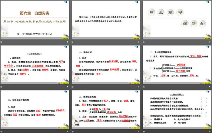
Part One Content: Learning Objectives:
1. Understand the main types and characteristics of geographic information technology.
2. Master the working principles of major geographical information technologies and their applications in disaster prevention and reduction.
PPT on the application of geographical information technology in disaster prevention and reduction, part 2: independent preview and exploration of new knowledge
1. Remote sensing technology
1. Concept: Remote sensing technology is a geographical information technology that uses ______ or __________ mounted on an aircraft or spacecraft to ______ objects on the earth's surface.
2. Features: Detect ______, obtain information ______, short cycle, large amount of information, affected by ground conditions ______.
3. application
(1) Monitor the ______ of floods, typhoons and other disasters in real time and carry out accurate _____ and _______.
(2) Quickly identify the ______ of sudden disasters such as earthquakes and provide powerful ______ for disaster statistics and disaster relief.
2. Global satellite navigation system
1. Meaning: Geographic information technology that uses satellites to carry out real-time _______ around the world.
2. System composition
Space part - _______ ground
Control part - ground monitoring system
User part - _______ system
3. Features: _______, all-weather, continuity and _______.
4. application
Through the signal receiving equipment, accurate _______ is carried out to help users send out _______, timely report and disaster situation, and effectively _______ rescue and search time.
PPT on the application of geographical information technology in disaster prevention and reduction, part three: cooperative exploration to overcome difficult problems
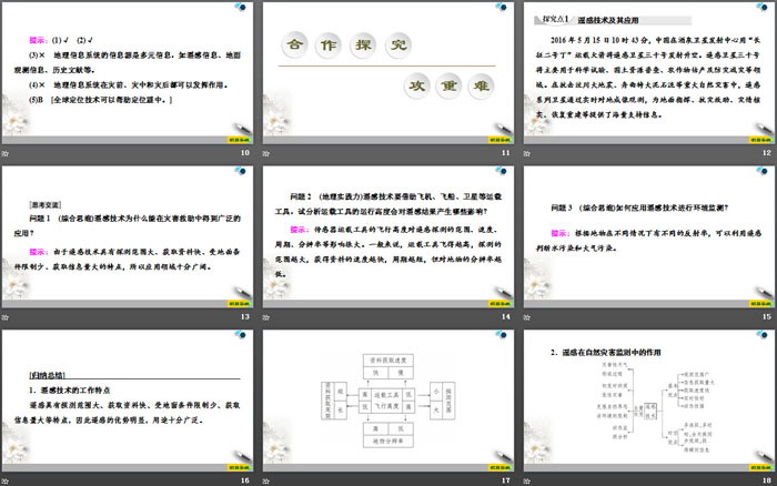
Remote sensing technology and its applications
At 10:43 on May 15, 2016, China launched the remote sensing satellite No. 30 from the Jiuquan Satellite Launch Center using the "Long March 2D" carrier rocket. Remote sensing satellite No. 30 will be mainly used in scientific experiments, land and resources census, crop yield estimation and disaster prevention and reduction. In the fight against major natural disasters such as the Wenchuan Earthquake and the Zhouqu Debris Flow, remote sensing satellites have provided massive support information for ground command, disaster relief, disaster verification, recovery and reconstruction through real-time ground imaging observations.
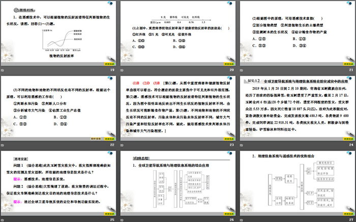
Question 1 (Comprehensive thinking) Why can remote sensing technology be widely used in disaster relief?
Tip: Because remote sensing technology has the characteristics of large detection range, fast data acquisition, few restrictions on ground conditions, and large amount of information, the application field is very broad.
Question 2 (Geographical practice) Remote sensing technology relies on aircraft, spaceships, satellites and other vehicles. Try to analyze what impact the operating altitude of the vehicle will have on the remote sensing results?
Tip: The flight altitude of the sensor carrier has a great influence on the range, speed, period, resolution, etc. of remote sensing detection. Generally speaking, the higher the vehicle flies, the wider the detection range, the faster the data is obtained, and the shorter the cycle, but the lower the resolution of ground objects.
Question 3 (Comprehensive thinking) How to apply remote sensing technology for environmental monitoring?
Tip: Based on the different reflectivity of ground objects under different circumstances, remote sensing can be used to determine water pollution and air pollution.
[Summary]
1. Working characteristics of remote sensing technology
Remote sensing has the characteristics of large detection range, fast data acquisition, few restrictions on ground conditions, and large amount of information obtained. Therefore, remote sensing has obvious advantages and is widely used.
2. The role of remote sensing in natural disaster monitoring
PPT on the application of geographical information technology in disaster prevention and reduction, part 4: Competing literacy standards and solidifying the basics
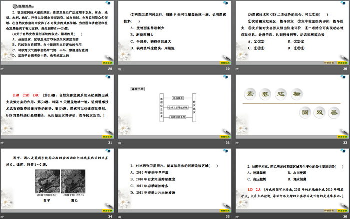
1. Comparing the two satellite photos, we can directly conclude that this area ()
A. Severe drought in spring 2010
B. The river has continued to widen since 2010
C. Lakes increased in spring 2011
D. Large areas of land were flooded in the spring of 2011
2. Compared with Figure A, the main reason for the changes in this area during the period shown in Figure B is ()
A. Continuous heavy rain B. Flood irrigation of farmland
C. High pressure control D. Seawater backflow
1.D 2.A Comparing the two pictures, it can be seen that the water area in 2011 was significantly larger than that in 2010, and large areas of land were flooded. The main reason for the increase in river water is most likely the continuous heavy rain. ]
The Beidou satellite navigation system is a global satellite positioning and communication system independently developed by my country. It is the fourth mature satellite navigation system after the American Global Positioning System, the Russian GLONASS satellite navigation system, and the European Galileo satellite navigation system. The Beidou satellite navigation system can provide users with high-precision and high-reliability positioning, navigation, and timing services around the world and around the clock, and has short message communication capabilities. Answer the following questions based on the material.
3. The geographical information technology used by the Beidou satellite navigation system is ()
A. Remote Sensing (RS) B. Geographic Information System (GIS)
C. Global Navigation Satellite System (GNNS) D. digital earth
4. The main roles played by the Beidou satellite navigation system in earthquake relief are ()
① Provide images of disaster areas ② Statistics of economic losses in disaster areas
③ Determine the location of disaster relief personnel ④ Provide short text contact
A. ①② B. ①③
C. ②③ D. ③④
Keywords: PPT courseware for high school geography required by the People's Education Press is available for free download, application of geographic information technology in disaster prevention and reduction PPT download, natural disaster PPT download, .PPT format;
For more information about the "Application of Natural Disasters Geographic Information Technology in Disaster Prevention and Mitigation" PPT courseware, please click the "Natural Disasters PPT Application of Geographic Information Technology in Disaster Prevention and Mitigation" PPT tag.
"Application of Geographic Information Technology in Disaster Prevention and Mitigation" Natural Disaster PPT Courseware:
"Application of Geographic Information Technology in Disaster Prevention and Mitigation" Natural Disasters PPT Courseware Part One: Course Standard Explanation 1. Understand the working principles of remote sensing technology, global satellite navigation systems and geographic information systems and master their characteristics. 2. Give examples of remote sensing technology and global satellites..
File Info
Update Time: 2024-07-10
This template belongs to Geography courseware People's Education Press High School Geography Compulsory Course 1 industry PPT template
"Application of Geographic Information Technology in Disaster Prevention and Mitigation" Natural Disasters PPT Simple campus recruitment activity planning plan summary enterprise and institution recruitment publicity lecture PPT template is a general PPT template for business post competition provided by the manuscript PPT, simple campus recruitment activity planning plan summary enterprise and institution recruitment promotion Lecture PPT template, you can edit and modify the text and pictures in the source file by downloading the source file. If you want more exquisite business PPT templates, you can come to grid resource. Doug resource PPT, massive PPT template slide material download, we only make high-quality PPT templates!
Tips: If you open the template and feel that it is not suitable for all your needs, you can search for related content "Application of Geographic Information Technology in Disaster Prevention and Mitigation" Natural Disasters PPT is enough.
How to use the Windows system template
Directly decompress the file and use it with office or wps
How to use the Mac system template
Directly decompress the file and use it Office or wps can be used
Related reading
For more detailed PPT-related tutorials and font tutorials, you can view: Click to see
How to create a high-quality technological sense PPT? 4 ways to share the bottom of the box
Notice
Do not download in WeChat, Zhihu, QQ, built-in browsers, please use mobile browsers to download! If you are a mobile phone user, please download it on your computer!
1. The manuscript PPT is only for study and reference, please delete it 24 hours after downloading.
2. If the resource involves your legitimate rights and interests, delete it immediately.
3. Contact information: service@daogebangong.com
"Application of Geographic Information Technology in Disaster Prevention and Mitigation" Natural Disasters PPT, due to usage restrictions, it is only for personal study and reference use. For commercial use, please go to the relevant official website for authorization.
(Personal non-commercial use refers to the use of this font to complete the display of personal works, including but not limited to the design of personal papers, resumes, etc.)
Preview
Related Search: