Business Planet Edition 7th Grade Geography Volume 1
People's Education Edition Geography for Seventh Grade Volume 2
Business Planet Edition 7th Grade Geography Volume 2
Business Planet Edition Geography for Grade 8 Volume 1
People's Education Edition Geography for Eighth Grade Volume 2
Hunan Education Edition High School Geography Compulsory Course I
Shanghai Education Edition Seventh Grade Geography Volume 1
People's Education Edition Geography for Grade 8 Volume 1
Compulsory Course 1 of High School Geography in China Graphics Edition
People's Education Edition Geography for Grade 7 Volume 1
Shanghai Education Edition Geography for Sixth Graders Volume 1
Lu Ke version of high school geography compulsory course I
People's Education Press High School Geography Compulsory Course 1
Hunan Education Edition High School Geography Compulsory Course II
Business Planet Edition Geography for Eighth Grade Volume 2
Shanghai Education Edition Seventh Grade Geography Volume 2

| Category | Format | Size |
|---|---|---|
| People's Education Edition Geography for Grade 8 Volume 1 | pptx | 6 MB |

"Topography and Relief" China's Natural Environment PPT Courseware 5
2024-11-23
Copyright statement: This material is compiled and released by the user of Daoge Resources. The copyright belongs to the author. For commercial use, please contact the copyright owner. If there is any infringement, please contact the webmaster to remove the resource.
Download Points: 0.00
Free Download
Upgrade VIP
Favorite
Views: 2016 / Downloads: 458
Description
"Topography and Relief" China's Natural Environment PPT Courseware 5
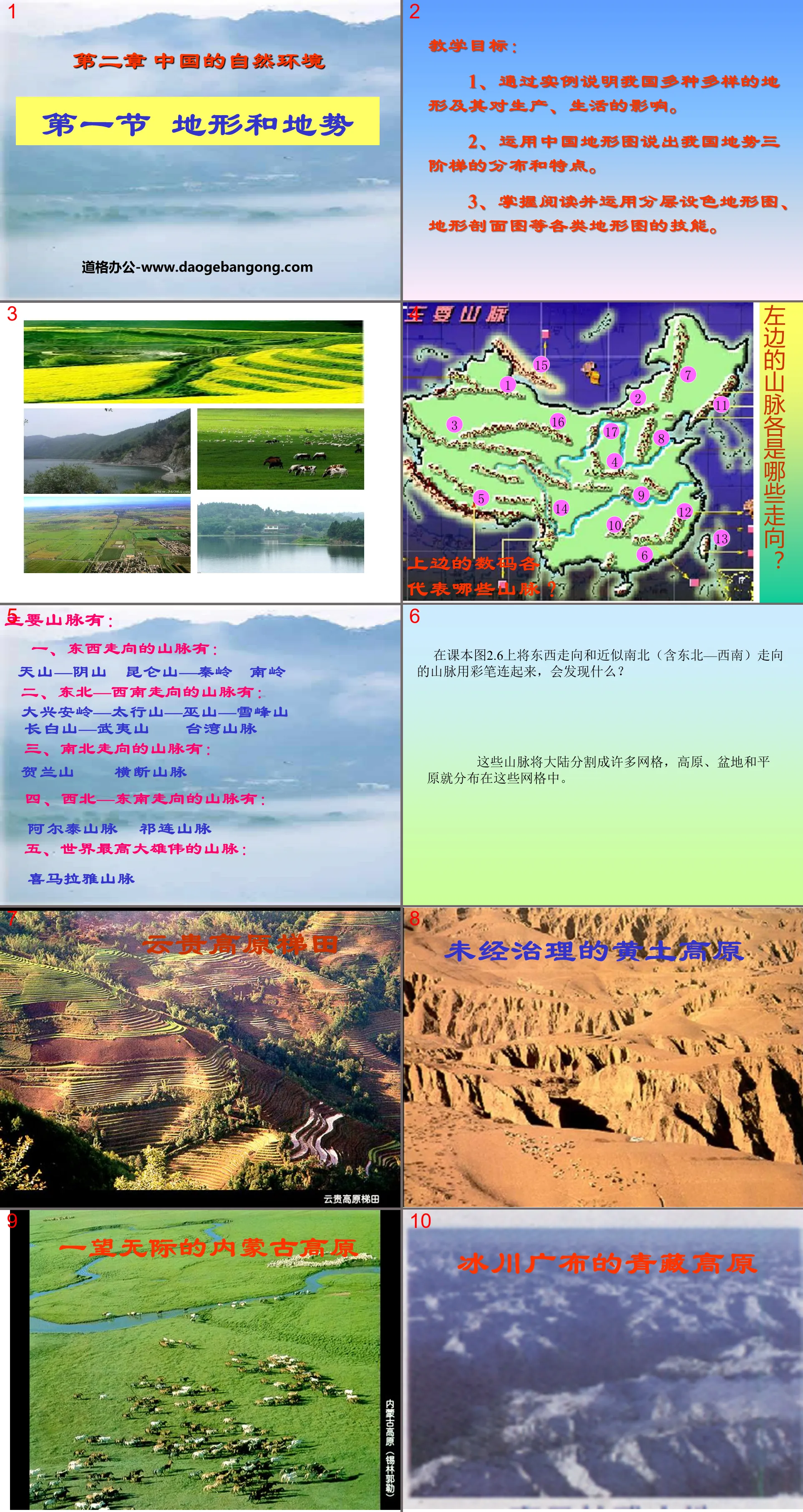
teaching objectives:
1. Explain through examples the various terrains in our country and their impact on production and life.
2. Use China’s topographic map to describe the distribution and characteristics of the three terrain ladders in my country.
3. Master the skills of reading and using various topographic maps such as layered color topographic maps and topographic profile maps.
The main mountain ranges are:
1. Mountains running east-west include:
Tianshan-Yinshan Kunlun Mountain-Qinling Nanling
2. The mountains running from northeast to southwest include:
Daxinganling—Taihang Mountain—Wushan Mountain—Xuefeng Mountain
Changbai Mountain-Wuyi Mountain Taiwan Mountains
3. The mountains running north to south include:
Helan Mountain Hengduan Mountains
4. The mountains running from northwest to southeast include:
Altai Mountains Qilian Mountains
5. The tallest and majestic mountains in the world:
Himalayas
Collaborative research questions:
1. What are the favorable conditions and unfavorable factors for the development and utilization of mountainous areas?
Disadvantages:
The rugged ground and inconvenient transportation are not conducive to the development of farming operations.
Advantages:
Develop forestry, animal husbandry, tourism, mining, etc.
2. Think about it: How to develop and construct mountainous areas?
(1) Efforts to improve traffic conditions;
(2) Vigorously develop tourism;
(3) Rationally develop mineral resources;
(4) Actively implement agricultural diversification;
(5) Introduce talents and develop education
Climate: It is high in the west and low in the east, tilting toward the ocean, which facilitates the moist airflow from the sea to penetrate deep into the inland and form precipitation.
Rivers: Many large rivers flow eastward, facilitating east-west transportation.
Water energy resources: When the river flows from a higher level to a lower level, the gap is large and the water energy resources are extremely rich.
feedback exercise
1. Among the following mountain ranges, those that are both the first and second step boundary mountains and run northwest-southeast are:
A. Kunlun Mountains B. Qilian Mountains
C.Hengduan Mountain D.Taihang Mountain
2. The following groups of mountains and terrain areas are adjacent to each other:
A.Kunlun Mountain----Inner Mongolia Plateau B.Qinling Mountains----Loess Plateau
C. Hengduan Mountain ---- Tarim Basin D. Wushan ---- Northeast Plain
3. Among the following mountains, the third step is:
A.Tianshan B.Hengduanshan C.Wuyishan D.Yinshan
What do you know?
Terrain characteristics: high in the west and low in the east, distributed in a ladder shape
Terrain characteristics: complex and diverse terrain, vast mountainous area
Terrain distribution:
Main mountain ranges and four plateaus
Four major basins and three major plains
Keywords: China's natural environment teaching courseware, terrain and relief teaching courseware, People's Education Edition eighth grade geography PPT courseware download, eighth grade geography slide courseware download, China's natural environment PPT courseware download, topography and relief PPT courseware download, .PPT format;
For more information about the "China's Natural Environment Topography and Relief" PPT courseware, please click on the China's Natural Environment ppt topography and relief ppt tag.
"Topography and Relief" China's Natural Environment PPT Courseware 9:
"Topography and Relief" China's Natural Environment PPT Courseware 9 Four major plateaus: Qinghai-Tibet Plateau, Inner Mongolia Plateau, Loess Plateau, Yunnan-Guizhou Plateau Four major basins: Tarim Basin, Junggar Basin, Qaidam Basin, Sichuan Basin Three major plains: Northeast Plain , Huabeiping...
"Topography and Relief" China's Natural Environment PPT Courseware 8:
"Topography and Relief" China's Natural Environment PPT Courseware 8 Learning Objectives 1. Topography 2. Basic characteristics of terrain 3. Boundary lines between ladders 4. Characteristics of three-level ladders 5. The impact of terrain characteristics on my country's natural environment and economic activities 6. Practice... ...the basics of terrain...
"Topography and Relief" China's Natural Environment PPT Courseware 7:
"Topography and Relief" China's Natural Environment PPT Courseware 7 Do it Find out the main mountain ranges with different directions. Main mountain ranges: East-west direction: Tianshan Yinshan Mountains, Kunlun Mountains, Qinling Mountains, Nanling Mountains, northeast-southwest direction: Greater Hinggan Mountains, Taihang Mountains, Wushan Xuefeng Mountains, Changbai Mountains, Wuyi Mountains, Taiwan...
File Info
Update Time: 2024-11-23
This template belongs to Geography courseware People's Education Edition Geography for Grade 8 Volume 1 industry PPT template
"Topography and Relief" China's Natural Environment PPT Courseware 5 Simple campus recruitment activity planning plan summary enterprise and institution recruitment publicity lecture PPT template is a general PPT template for business post competition provided by the manuscript PPT, simple campus recruitment activity planning plan summary enterprise and institution recruitment promotion Lecture PPT template, you can edit and modify the text and pictures in the source file by downloading the source file. If you want more exquisite business PPT templates, you can come to grid resource. Doug resource PPT, massive PPT template slide material download, we only make high-quality PPT templates!
Tips: If you open the template and feel that it is not suitable for all your needs, you can search for related content "Topography and Relief" China's Natural Environment PPT Courseware 5 is enough.
How to use the Windows system template
Directly decompress the file and use it with office or wps
How to use the Mac system template
Directly decompress the file and use it Office or wps can be used
Related reading
For more detailed PPT-related tutorials and font tutorials, you can view: Click to see
How to create a high-quality technological sense PPT? 4 ways to share the bottom of the box
Notice
Do not download in WeChat, Zhihu, QQ, built-in browsers, please use mobile browsers to download! If you are a mobile phone user, please download it on your computer!
1. The manuscript PPT is only for study and reference, please delete it 24 hours after downloading.
2. If the resource involves your legitimate rights and interests, delete it immediately.
3. Contact information: service@daogebangong.com
"Topography and Relief" China's Natural Environment PPT Courseware 5, due to usage restrictions, it is only for personal study and reference use. For commercial use, please go to the relevant official website for authorization.
(Personal non-commercial use refers to the use of this font to complete the display of personal works, including but not limited to the design of personal papers, resumes, etc.)
Preview
Related Search:
"Topography and Relief" China's Natural Environment PPT Courseware 5
2024-11-23
Copyright statement: This material is compiled and released by the user of Daoge Resources. The copyright belongs to the author. For commercial use, please contact the copyright owner. If there is any infringement, please contact the webmaster to remove the resource.
Download Points: 0.00
Free Download
Upgrade VIP
Favorite
Views: 2016 / Downloads: 458


