Business Planet Edition 7th Grade Geography Volume 1
Business Planet Edition 7th Grade Geography Volume 2
People's Education Edition Geography for Seventh Grade Volume 2
Business Planet Edition Geography for Grade 8 Volume 1
People's Education Edition Geography for Eighth Grade Volume 2
Hunan Education Edition High School Geography Compulsory Course I
Shanghai Education Edition Seventh Grade Geography Volume 1
People's Education Edition Geography for Grade 8 Volume 1
Compulsory Course 1 of High School Geography in China Graphics Edition
People's Education Edition Geography for Grade 7 Volume 1
Shanghai Education Edition Geography for Sixth Graders Volume 1
Lu Ke version of high school geography compulsory course I
People's Education Press High School Geography Compulsory Course 1
Hunan Education Edition High School Geography Compulsory Course II
Shanghai Education Edition Seventh Grade Geography Volume 2
Business Planet Edition Geography for Eighth Grade Volume 2

| Category | Format | Size |
|---|---|---|
| Shanghai Education Edition Geography for Sixth Graders Volume 1 | pptx | 6 MB |

"Jingwei Network on the Map" PPT courseware download
2024-11-22
Copyright statement: This material is compiled and released by the user of Daoge Resources. The copyright belongs to the author. For commercial use, please contact the copyright owner. If there is any infringement, please contact the webmaster to remove the resource.
Download Points: 0.00
Free Download
Upgrade VIP
Favorite
Views: 3996 / Downloads: 811
Description
"Jingwei Network on the Map" PPT courseware download
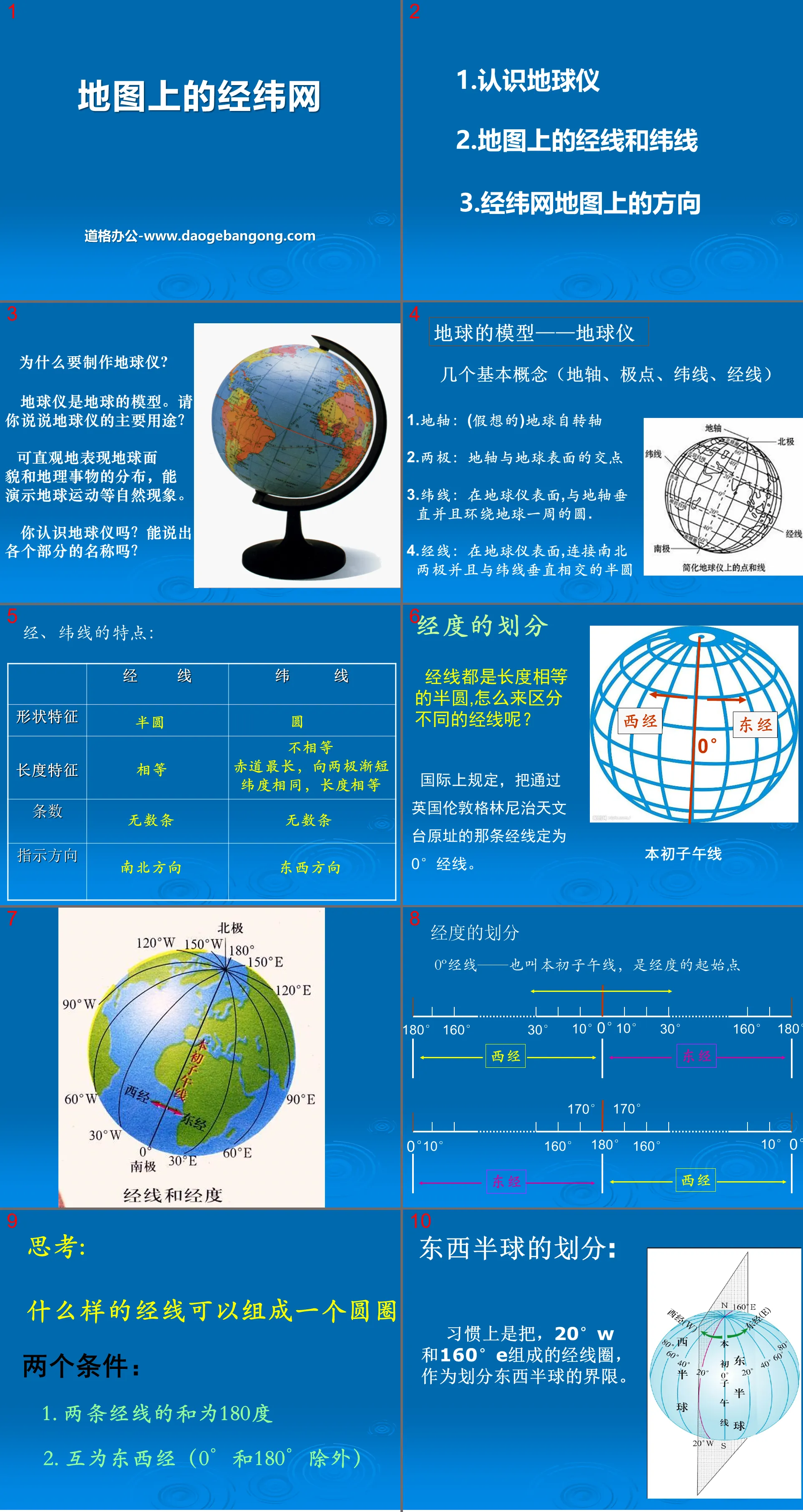
Part 1: Why make a globe?
A globe is a model of the earth. Could you please tell me the main purpose of the globe?
It can intuitively express the appearance of the earth and the distribution of geographical things, and can demonstrate natural phenomena such as earth movement.
Do you know the globe? Can you name the various parts?
Model of the Earth - Globe
Several basic concepts (earth axis, poles, latitudes, longitudes)
1. Earth’s axis: (imaginary) Earth’s rotation axis
2. Poles: The intersection of the Earth’s axis and the Earth’s surface
3. Parallel of latitude: A circle on the surface of the globe that is perpendicular to the earth's axis and goes around the earth.
4. Longitude: On the surface of the globe, the semicircle connecting the north and south poles and intersecting perpendicularly with the latitudes
Latitude and longitude network PPT on the map, part 2: division of longitude
Meridians are all semicircles of equal length. How to distinguish different meridians?
Internationally, the longitude passing through the original site of the Greenwich Observatory in London, England, is designated as the 0° longitude.
Thinking: What kind of longitude lines can form a circle?
Two conditions:
1. The sum of two longitudes is 180 degrees
2. The east and west longitudes of each other (except 0° and 180°)
Jingwei Network PPT on the map, part 3: Think about it
Determine whether the picture represents east longitude or west longitude? Southern latitude or northern latitude?
The east longitude increases toward the east, and the west longitude increases toward the west.
Northern latitude increases toward the north, and southern latitude increases toward the south.
Keywords: Shanghai Education Edition Geography PPT courseware for the first volume of the sixth grade for free download, PPT download of the latitude and longitude network on the map, .PPT format;
For more information about the PPT courseware "Jingwei Network on the Map", please click the Jingwei Network on the Map ppt tab.
"Jingwei Network on the Map" PPT download:
"Latitude and Longitude Network on the Map" PPT download Part 1: Course content 1. Understanding the globe. Model globe of the earth. Axis, North Pole, South Pole, Equator. 2. Meridian and Latitude Network. What is the difference between longitude and latitude lines? Longitude: The line on the Earth's surface that connects north and south...
"Jingwei Network on the Map" PPT courseware:
Contents of the first part of the PPT courseware "Longitude and Latitude Network on the Map": Revolution and rotation Earth's rotation 1. The direction of the Earth's rotation is ________; 2. The period of the Earth's rotation is __________; 3. Looking at the Earth's rotation above the North Pole, it appears _______ _direction;..
"Jingwei Network on the Map" PPT:
The first part of the PPT "Gratitude and Latitude Network on the Map": Understanding the Globe, a scaled-down model. Earth's axis, North Pole, South Pole, Equator. First understanding of longitude and latitude lines Longitude: also called meridian. Connecting the north and south poles, two corresponding longitudes form a complete circle (..
File Info
Update Time: 2024-11-22
This template belongs to Geography courseware Shanghai Education Edition Geography for Sixth Graders Volume 1 industry PPT template
"Jingwei Network on the Map" PPT courseware download Simple campus recruitment activity planning plan summary enterprise and institution recruitment publicity lecture PPT template is a general PPT template for business post competition provided by the manuscript PPT, simple campus recruitment activity planning plan summary enterprise and institution recruitment promotion Lecture PPT template, you can edit and modify the text and pictures in the source file by downloading the source file. If you want more exquisite business PPT templates, you can come to grid resource. Doug resource PPT, massive PPT template slide material download, we only make high-quality PPT templates!
Tips: If you open the template and feel that it is not suitable for all your needs, you can search for related content "Jingwei Network on the Map" PPT courseware download is enough.
How to use the Windows system template
Directly decompress the file and use it with office or wps
How to use the Mac system template
Directly decompress the file and use it Office or wps can be used
Related reading
For more detailed PPT-related tutorials and font tutorials, you can view: Click to see
How to create a high-quality technological sense PPT? 4 ways to share the bottom of the box
Notice
Do not download in WeChat, Zhihu, QQ, built-in browsers, please use mobile browsers to download! If you are a mobile phone user, please download it on your computer!
1. The manuscript PPT is only for study and reference, please delete it 24 hours after downloading.
2. If the resource involves your legitimate rights and interests, delete it immediately.
3. Contact information: service@daogebangong.com
"Jingwei Network on the Map" PPT courseware download, due to usage restrictions, it is only for personal study and reference use. For commercial use, please go to the relevant official website for authorization.
(Personal non-commercial use refers to the use of this font to complete the display of personal works, including but not limited to the design of personal papers, resumes, etc.)
Preview
Related Search:
"Jingwei Network on the Map" PPT courseware download
2024-11-22
Copyright statement: This material is compiled and released by the user of Daoge Resources. The copyright belongs to the author. For commercial use, please contact the copyright owner. If there is any infringement, please contact the webmaster to remove the resource.
Download Points: 0.00
Free Download
Upgrade VIP
Favorite
Views: 3996 / Downloads: 811


