The second volume of history for eighth grade compiled by the People's Education Publishing House
Zhonghua Book Company Edition Seventh Grade History Volume 2
Zhonghua Book Company Edition Eighth Grade History Volume 2
People's Education Edition Eighth Grade History Volume 1
Yuelu Edition Seventh Grade History Volume 2
People's Education Press Seventh Grade History Volume 1
Volume 1 of the seventh grade history compiled by the People's Education Publishing House
People's Education Edition History and Society 9th Grade Part II
People's Education Press History and Society Grade 9
People's Education Edition Eighth Grade History Volume 2
People's Education Press History and Society Grade 7
People's Education Press History and Society for Grade 8 Volume 1
People's Education Press Seventh Grade History Volume 2
People's Education Press Ninth Grade History Volume 2
East China Normal University Edition Seventh Grade History Volume 1
Yuelu Edition Seventh Grade History Volume 1
| Category | Format | Size |
|---|---|---|
| People's Education Press History and Society seventh grade | pptx | 6 MB |

"Getting Information from the Map" People Live in Society PPT
2024-10-03
Copyright statement: This material is compiled and released by the user of Daoge Resources. The copyright belongs to the author. For commercial use, please contact the copyright owner. If there is any infringement, please contact the webmaster to remove the resource.
Download Points: 0.00
Free Download
Upgrade VIP
Favorite
Views: 3532 / Downloads: 594
Description
"Getting Information from the Map" People Live in Society PPT
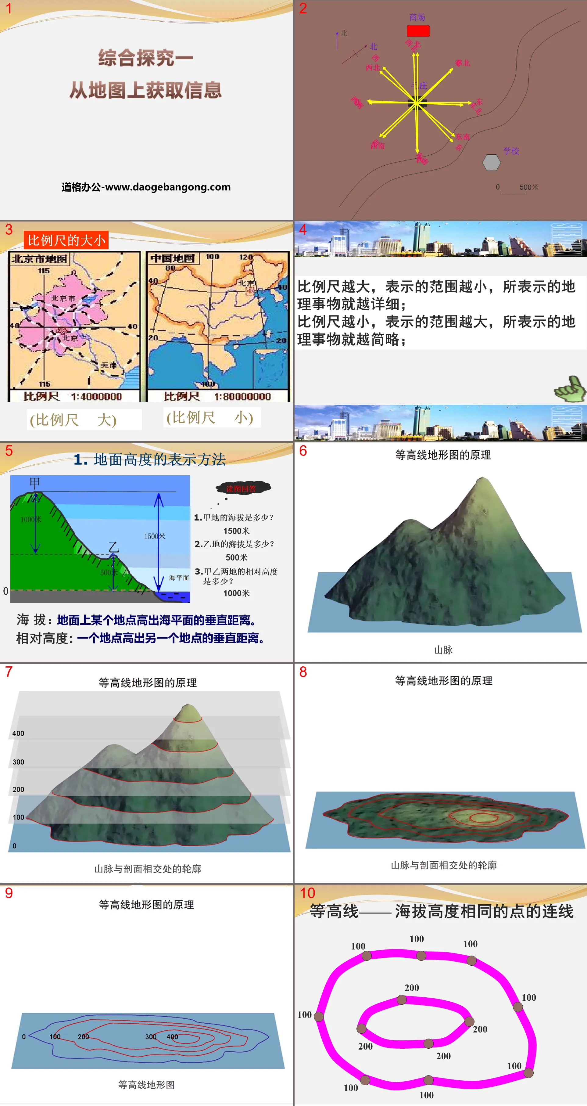
Part 1: The size of the scale
The larger the scale, the smaller the range represented and the more detailed the geographical things represented;
The smaller the scale, the larger the range represented and the simpler the geographical things represented;
1. How to express the height of the ground
Reading pictures and answering
1. What is the altitude of A?
1500 meters
2. What is the altitude of place B?
500 meters
3. What is the relative height of place A and place B?
1000 meters
Altitude: The vertical distance a location on the ground is above sea level.
Relative height: The vertical distance one location is above another location.
2. Contour topographic map
Closed curves connecting points with the same altitude are called contour lines.
Features of contour lines:
1. On the same contour line, the altitude of each point is the same.
2. Contour lines
Large value - high altitude
Small value - low altitude
3. Contour lines
Densely distributed - steep slope
Sparse distribution - gentle slope
Obtaining information from maps PPT, part 2: Application of contour maps
(1) Site selection of reservoir dam:
Generally, it is selected in a canyon, and considering that the reservoir site should be selected in a "pocket-shaped" depression in a river valley or valley area. Because it is located in the upper reaches of the river, the terrain is open, making it easy to dam the river and not occupy a lot of farmland.
(2) Construction of roads and railway lines
Generally, walking along the contour line can reduce the difficulty of construction.
Construction of roads between EF:
Can reduce the amount of road construction work
The road is flat, making it easier for vehicles to travel
Not easy to cause soil erosion
Obtaining information from the map PPT, part 3: classroom feedback
Read the following contour topographic map and answer the questions:
1. The altitude of point A in the picture is _____ meters, and the altitude of point B is _____ meters; the relative height between them is _____ meters.
2. From the perspective of terrain location, A is _____; B is _____; C is _____; D is _____.
3. If a tourist plans to climb the mountain from two routes, M and N, which route is easier? Why?
Route M is easier. The reason is: the contour lines at M are sparsely distributed and the mountain slope is gentle.
4. Which of the four places A, B, C and D may have rivers (streams) passing through? Why?
C land. The reason is that it is located in a valley and is a water catchment area.
Get information from the map PPT, Part 4: Travel with a map
During the summer vacation, Chen Tianyu, who lives in Hangzhou, Zhejiang, plans to travel to Xiamen, Fujian with his parents. What maps do he need to prepare?
Let’s talk about it: Do you all know what types of maps there are?
Political district maps, tourism maps, urban area maps, traffic maps, historical changes maps, contour topographic maps, precipitation distribution maps, population distribution maps, satellite cloud maps, military maps...
Read the following paragraphs and talk about what kind of maps these three students need to choose?
Scenario 1 Our class is going to go to the mountainous areas for cross-country activities. What kind of plan needs to be designed in advance.
Scenario 2 A strong earthquake of magnitude 7.6 occurs in Pakistan. Do you know where this country is?
Scenario 3 If you travel to other places, what kind of map do you need?
Obtaining information from the map PPT, Part 5: Simulated tourism
If one day you want to travel to Xiamen, Fujian Province, what maps do you need to prepare?
Political district map, traffic map, urban area map, tourist map, topographic map...
Step one: Where is Xiamen?
What information can be learned from these two maps?
How would you choose a map? Tell me why.
Step 2: How to get to Xiamen?
Look at Figure 1-37, the traffic route map of China’s southeastern coastal areas, and answer question P19
Mode of transportation: train, bus, airplane
Choice: (consider time, cost, comfort level)
Step 3: How to find a given location?
Step 4: How to design a travel route?
Well-designed travel routes
Principle: Take the least repetitive routes and visit the most types of attractions.
hint:
1. Determine the location of the starting point, which is the starting point for designing the tour route;
2. There are no basic facilities such as hotels in each scenic spot;
3. Try to connect tourist attractions of different natures into circular or polygonal routes to avoid duplication of round-trip routes.
Keywords: free download of PPT courseware for seventh-grade history and society from People's Education Edition, PPT download of people living in society, PPT download of obtaining information from maps, .PPT format;
For more information about the PPT courseware "People Live in Society and Get Information from Maps", please click on the "People Live in Society and Get Information from Maps" ppt tag.
"Country and City" People Live in Society PPT Download:
"Country and City" People Live in Society PPT Download Part One: The Formation and Development of Urban Settlement The rural scale and building area are getting larger and larger. The commercial administrative center has a rural population that has become an urban population. Agricultural production has become an industrial production city. .. ....
"Country and City" People Live in Society PPT Courseware:
"Country and City" People Live in Society PPT Courseware Part One: Rural Settlement 1. The meaning of rural settlement Rural settlement: that is, a village, is the place where people live in rural areas, and is also a place where people carry out production and social activities. 2. Rural settlements..
"Country and City" People Live in Society PPT:
"Country and City" People Live in Society PPT Part One Content: Rural Settlement 1. Definition (first paragraph of text P9) Rural settlements, that is, villages, are the places where people live in rural areas and are also places where people carry out production and social activities. . 2. Of rural settlements..
File Info
Update Time: 2024-10-03
This template belongs to History courseware People's Education Press History and Society seventh grade industry PPT template
"Getting Information from the Map" People Live in Society PPT Simple campus recruitment activity planning plan summary enterprise and institution recruitment publicity lecture PPT template is a general PPT template for business post competition provided by the manuscript PPT, simple campus recruitment activity planning plan summary enterprise and institution recruitment promotion Lecture PPT template, you can edit and modify the text and pictures in the source file by downloading the source file. If you want more exquisite business PPT templates, you can come to grid resource. Doug resource PPT, massive PPT template slide material download, we only make high-quality PPT templates!
Tips: If you open the template and feel that it is not suitable for all your needs, you can search for related content "Getting Information from the Map" People Live in Society PPT is enough.
How to use the Windows system template
Directly decompress the file and use it with office or wps
How to use the Mac system template
Directly decompress the file and use it Office or wps can be used
Related reading
For more detailed PPT-related tutorials and font tutorials, you can view: Click to see
How to create a high-quality technological sense PPT? 4 ways to share the bottom of the box
Notice
Do not download in WeChat, Zhihu, QQ, built-in browsers, please use mobile browsers to download! If you are a mobile phone user, please download it on your computer!
1. The manuscript PPT is only for study and reference, please delete it 24 hours after downloading.
2. If the resource involves your legitimate rights and interests, delete it immediately.
3. Contact information: service@daogebangong.com
"Getting Information from the Map" People Live in Society PPT, due to usage restrictions, it is only for personal study and reference use. For commercial use, please go to the relevant official website for authorization.
(Personal non-commercial use refers to the use of this font to complete the display of personal works, including but not limited to the design of personal papers, resumes, etc.)
Preview
Related Search:
"Getting Information from the Map" People Live in Society PPT
2024-10-03
Copyright statement: This material is compiled and released by the user of Daoge Resources. The copyright belongs to the author. For commercial use, please contact the copyright owner. If there is any infringement, please contact the webmaster to remove the resource.
Download Points: 0.00
Free Download
Upgrade VIP
Favorite
Views: 3532 / Downloads: 594


