Business Planet Edition 7th Grade Geography Volume 1
Business Planet Edition 7th Grade Geography Volume 2
People's Education Edition Geography for Seventh Grade Volume 2
Business Planet Edition Geography for Grade 8 Volume 1
Shanghai Education Edition Seventh Grade Geography Volume 1
People's Education Edition Geography for Eighth Grade Volume 2
Hunan Education Edition High School Geography Compulsory Course I
Compulsory Course 1 of High School Geography in China Graphics Edition
People's Education Edition Geography for Grade 7 Volume 1
Hunan Education Edition High School Geography Compulsory Course II
Shanghai Education Edition Geography for Sixth Graders Volume 1
Business Planet Edition Geography for Eighth Grade Volume 2
People's Education Edition Geography for Grade 8 Volume 1
Lu Ke version of high school geography compulsory course I
Shanghai Education Edition Seventh Grade Geography Volume 2
People's Education Press High School Geography Compulsory Course 1

| Category | Format | Size |
|---|---|---|
| Hunan Education Edition High School Geography Compulsory Course I | pptx | 6 MB |

"Karst, Coastal and Glacier Landforms" Earth Surface Form PPT
2024-10-18
Copyright statement: This material is compiled and released by the user of Daoge Resources. The copyright belongs to the author. For commercial use, please contact the copyright owner. If there is any infringement, please contact the webmaster to remove the resource.
Download Points: 0.00
Free Download
Upgrade VIP
Favorite
Views: 1898 / Downloads: 438
Description
"Karst, Coastal and Glacier Landforms" Earth Surface Form PPT
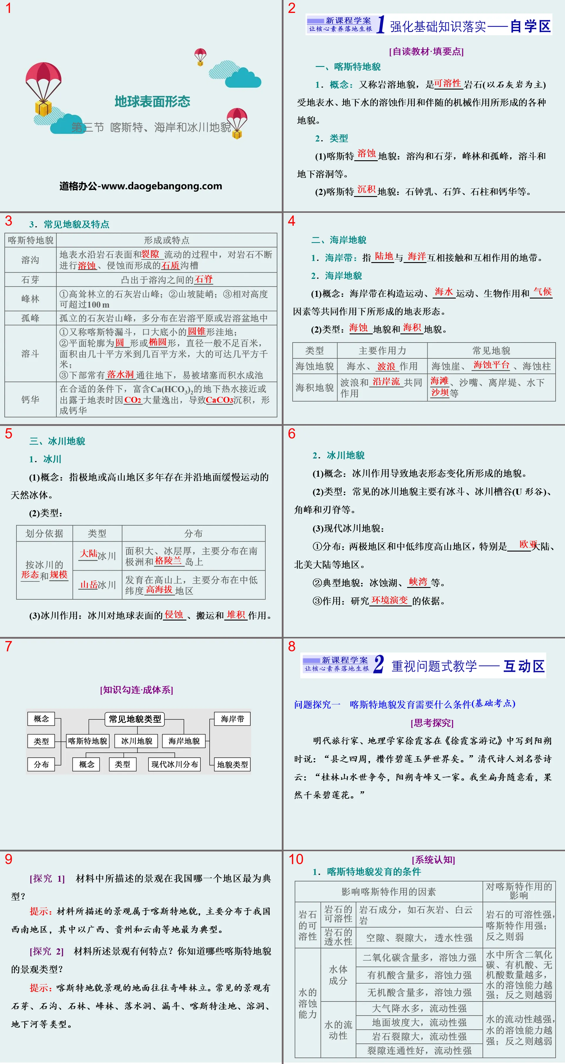
Part One: Strengthening the Implementation of Basic Knowledge
[Self-reading textbook·Fill in key points]
1. Karst landforms
1. Concept: Also known as karst landform, it is a variety of landforms formed by the dissolution of ____ rocks (mainly limestone) by surface water and groundwater and the accompanying mechanical effects.
2. type
(1) Karst ____ landforms: karst ravines and stone buds, peak forests and solitary peaks, karst buckets and underground caves, etc.
(2) Karst ____ landforms: stalactites, stalagmites, stone pillars and travertine, etc.
3. Common landforms and characteristics
2. Coastal landforms
1. Coastal zone: refers to the zone where ____ and ____ contact and interact with each other.
2. coastal landforms
(1) Concept: The surface form of the coastal zone is formed under the combined action of tectonic movement, ____ movement, biological action and ____ factors.
(2) Type: ____ landform and ____ landform.
3. Glacial landforms
1. glacier
(1) Concept: refers to natural ice bodies that have existed for many years in polar or high mountain areas and move slowly along the ground.
(2)Type:
(3) Glaciation: The ____, transportation and ____ effects of glaciers on the earth's surface.
2. glacial landforms
(1) Concept: Landform formed by changes in surface morphology caused by glaciation.
(2) Type: Common glacial landforms mainly include cirques, glacial troughs (U-shaped valleys), horn peaks, and blade ridges.
(3) Modern glacial landforms:
① Distribution: Polar regions and mid- and low-latitude alpine areas, especially ____ continent, North American continent and other regions.
②Typical landforms: glacial lakes, ____, etc.
③Function: The basis for studying ____.
Karst Coast and Glacier Landform PPT, Part 2: Pay Attention to Problem-Based Teaching
Question 1: What conditions are needed for the development of karst landformsBasic test points
[Thinking and exploring]
Xu Xiake, a traveler and geographer of the Ming Dynasty, wrote about Yangshuo in "Xu Xiake's Travel Notes": "The surrounding areas of the county are filled with green lotus and jade bamboo shoots." Liu Guangming, a poet of the Qing Dynasty, said in a poem: "Guilin's landscapes are always praised. Yangshuo has another amazing peak. I sat on a boat and looked around, and sure enough, there were thousands of green lotuses."
[Exploration 1] In which region of my country is the landscape described in the material the most typical?
Tip: The landscape described in the material belongs to karst landforms, which are mainly distributed in southwest my country, of which Guangxi, Guizhou and Yunnan are the most typical.
[Exploration 2] What are the characteristics of the landscape described in the material? What types of karst landscapes do you know?
Tip: The ground of karst landform landscape is often lined with strange peaks. Common landscapes include stone buds, stone ditches, stone forests, peak forests, sinkholes, funnels, karst depressions, caves, underground rivers and other types.
[Training to pass the test]
1. Read the picture below. The landforms and landscapes represented in the picture are mainly located in ()
A. Limestone distribution area B. Granite distribution area
C. Basalt distribution area D. Gneiss distribution area
2. The Chinese and foreign joint scientific expedition team once inspected the famous Dashiwei Tiankeng in Leye, Guangxi, and obtained valuable first-hand information. Tai Shek Wai Tiankeng is ()
A. Large crater B. deep depression basin
C. Crater D. a karst funnel
3. The picture below shows the karst landscape of the Lunan Stone Forest in Yunnan. The geological processes and rock types that shaped the Lunan Stone Forest are ()
A. Wind erosion, igneous rocks B. Water erosion, sedimentary rocks
C. Water erosion, metamorphic rocks D. Wind erosion, sedimentary rocks
4. The picture below is a schematic diagram of karst landforms. Picture stories answer the following questions.
(1) Write the name of the landform represented by the numbers in the picture:
①________, ②________, ⑤________.
(2) The landforms shown in the picture are widely distributed in _________ areas of my country, and the effects of forming this landforms are __________________.
(3) The landform in Guilin is “the best in the world”. Let’s describe the climate conditions for the development of this landform in Guilin.
Question 2: What are the common types of coastal landformsBasic test points
Research point (1) Sea erosion landform
[Thinking and exploring]
There is a huge rock standing on the southwest beach of Gulangyu Island in Xiamen City. There is a large cave in the middle. When the tide rises and falls, when the waves hit the cave, it makes a thumping sound like a drum. People call it "Gulang Stone".
[Explore] What is the external force that forms the Gulang Stone? What are the main landform types formed by this external force?
Hint: Wave erosion. Sea cliffs, sea pillars, sea arch bridges, sea platforms, etc.
Research point (2) Marine landforms
[Thinking and exploring]
Shishi Golden Coast is located in Yongning Town, Shishi, Quanzhou City, Fujian Province, on the west coast of the Taiwan Strait. It is known as one of the eight most beautiful coasts in the world. This is a crescent-shaped bay. The yellow beach is more than 500 meters long and has fine sand. Walking barefoot on it is like stepping on a cotton blanket and is very comfortable. You can wander in the shallow sea as close as you can, and you can reach the Emerald Island as far as the distance. It is known as the kiss between the desert and the sea. The picture above shows the landscape of Shishi Gold Coast.
[Explore] Which type of coastal landform does the beach in the picture belong to? In addition, what other common types of landforms are there?
Tip: marine landforms. Sand spits, offshore embankments, underwater sand bars, etc.
[System Cognition]
Beach development and utilization methods
The beach is an important base for aquaculture and the development of agricultural production; it is an important position for developing the ocean and developing marine industries. It contains various minerals, organisms and other marine resources; the beach can also be developed into a tourist resort such as leisure and entertainment.
[Training to pass the test]
1. The picture below shows a rock that looks like a "leopard" in the "Yeliu Geopark" in the northeast of Taiwan Island. During the survey in April 2011, it was found that the "leopard head" fell to the ground. The landform type is ()
A. Aeolian landform B. coastal landforms
C. Flowing water landform D. Yadan landform
Analysis: Sea erosion landforms often include sea erosion cliffs, sea erosion caves, sea erosion stacks, sea erosion platforms and sea erosion arch bridges (wave action is generally obvious on rocky coasts). The "leopard" rock can only be seen every year during the ebb of the lunar spring tide, indicating that the formation of this landform is related to the action of waves. If the "leopard head" falls on the ground, the leopard has "died", indicating that the erosion of the waves has broken the rock. .
2. The main external forces that form the landscape shown in Figure A are ()
A. Crustal movement B. running water accumulation
C. Wind erosion D. water erosion
3. Picture B is a photo of the famous tourist attraction "Southern Sky Pillar" in Hainan Province. the landscape()
A. Formed by seawater erosion B. Shows the characteristics of limestone deposition
C. Reflect the characteristics of tropical natural landscape D. Best viewed in winter
Analysis: Question 2, the landscape shown in Picture A is a typical wind-eroded mushroom, which is mostly found in the northwest inland of my country and is formed by wind erosion. Question 3: It can be seen from Figure B that it is located in the coastal area and the surface is well rounded. It can be seen that the landscape is greatly affected by seawater and is formed by long-term erosion of seawater. The landscape is coastal but not tropical natural landscape. Hainan scenery is better viewed in summer.
Question 3: What are the common glacial landformsBasic test points
[Thinking and exploring]
Geneva is the second largest city in Switzerland and enjoys a high reputation internationally. It is located in the southwest corner of Lake Geneva. Lake Geneva is beautiful, and many well-known writers and poets have praised and eulogized it. Henry James called it a "wonderfully blue lake"; Byron compared it to a crystal mirror. Lake Geneva is the largest of the Alpine lakes and is a moraine lake. It is said that during the Quaternary Ice Age, the Rhone River, which originated from the Alps, was blocked by moraine material in the Ecruze area, so the water gathered into a lake.
[Exploration 1] What are the main external forces responsible for the formation of Lake Geneva?
Hint: glaciation.
[Exploration 2] Which type of landscape is the most typical in the Alps?
Hint: glacial landforms.
Karst Coast and Glacier Landform PPT, Part Three: Carry out Structural Evaluation of Thinking
Structural evaluation of thinking—Guilin’s landscape is the best in the world
Guilin landscape is the general term for Guilin’s tourism resources. A national AAAAA tourist attraction and one of China's top ten scenic spots, Guilin's landscape is the representative of Chinese landscape. The typical karst terrain constitutes the unique Guilin landscape. Guilin's landscape refers to a wide range and has many projects. Guilin's landscape includes "green mountains, beautiful waters, strange caves and beautiful rocks", including mountains, waters, karst caves, stone carvings, etc. The landscape scenery within its territory is world-famous, and has enjoyed the reputation of "Guilin's landscape is the best in the world" for thousands of years. Based on the Guilin topography and relief map, discuss what are the conditions for the formation of Guilin's landscape?
Keywords: Hunan Education Edition High School Geography Compulsory Course 1 PPT Courseware Free Download, Karst Coast and Glacier Landform PPT Download, Earth Surface Form PPT Download, .PPT Format;
For more information about the PPT courseware "Earth Surface Morphology, Karst Coast and Glacier Landforms", please click the Earth Surface Morphology ppt Karst Coast and Glacier Landforms ppt tag.
"Karst, Coastal and Glacier Landforms" Earth Surface Form PPT Courseware:
"Karst, Coastal and Glacier Landforms" PPT Courseware on Earth's Surface Formation Part One Content: Course Standards: Through field observation or the use of videos and images, identify 3 to 4 landforms and describe the main characteristics of their landscapes. Literacy goals: 1. Through field observation or application..
"Aeolian Landforms" Earth's surface form PPT download:
"Aeolian Landform" Earth's Surface Form PPT Download Part One Content: Course Standards: Through field observation or the use of videos and images, identify 3 to 4 types of landforms and describe the main characteristics of their landscapes. Literacy goals: 1. Ability to observe in the field or use videos and images..
"Aeolian Landforms" Earth surface form PPT courseware:
"Aeolian Landform" PPT courseware on earth surface morphology Part 1: Basic review 1. Overview 1. _________ is the main sculptor of surface morphology in arid and semi-arid areas. 2. Aeolian landform, wind-eroded landform, aeolian landform 2. Wind-eroded landform 1. Wind erosion (1..
File Info
Update Time: 2024-10-18
This template belongs to Geography courseware Hunan Education Edition High School Geography Compulsory Course I industry PPT template
"Karst, Coastal and Glacier Landforms" Earth Surface Form PPT Simple campus recruitment activity planning plan summary enterprise and institution recruitment publicity lecture PPT template is a general PPT template for business post competition provided by the manuscript PPT, simple campus recruitment activity planning plan summary enterprise and institution recruitment promotion Lecture PPT template, you can edit and modify the text and pictures in the source file by downloading the source file. If you want more exquisite business PPT templates, you can come to grid resource. Doug resource PPT, massive PPT template slide material download, we only make high-quality PPT templates!
Tips: If you open the template and feel that it is not suitable for all your needs, you can search for related content "Karst, Coastal and Glacier Landforms" Earth Surface Form PPT is enough.
How to use the Windows system template
Directly decompress the file and use it with office or wps
How to use the Mac system template
Directly decompress the file and use it Office or wps can be used
Related reading
For more detailed PPT-related tutorials and font tutorials, you can view: Click to see
How to create a high-quality technological sense PPT? 4 ways to share the bottom of the box
Notice
Do not download in WeChat, Zhihu, QQ, built-in browsers, please use mobile browsers to download! If you are a mobile phone user, please download it on your computer!
1. The manuscript PPT is only for study and reference, please delete it 24 hours after downloading.
2. If the resource involves your legitimate rights and interests, delete it immediately.
3. Contact information: service@daogebangong.com
"Karst, Coastal and Glacier Landforms" Earth Surface Form PPT, due to usage restrictions, it is only for personal study and reference use. For commercial use, please go to the relevant official website for authorization.
(Personal non-commercial use refers to the use of this font to complete the display of personal works, including but not limited to the design of personal papers, resumes, etc.)
Preview
Related Search:
"Karst, Coastal and Glacier Landforms" Earth Surface Form PPT
2024-10-18
Copyright statement: This material is compiled and released by the user of Daoge Resources. The copyright belongs to the author. For commercial use, please contact the copyright owner. If there is any infringement, please contact the webmaster to remove the resource.
Download Points: 0.00
Free Download
Upgrade VIP
Favorite
Views: 1898 / Downloads: 438


