Business Planet Edition 7th Grade Geography Volume 2
Business Planet Edition Geography for Grade 8 Volume 1
Business Planet Edition 7th Grade Geography Volume 1
People's Education Edition Geography for Seventh Grade Volume 2
Shanghai Education Edition Seventh Grade Geography Volume 1
Business Planet Edition Geography for Eighth Grade Volume 2
Hunan Education Edition High School Geography Compulsory Course I
People's Education Edition Geography for Grade 7 Volume 1
People's Education Edition Geography for Eighth Grade Volume 2
Shanghai Education Edition Geography for Sixth Graders Volume 1
Lu Ke version of high school geography compulsory course I
Hunan Education Edition High School Geography Compulsory Course II
Shanghai Education Edition Seventh Grade Geography Volume 2
People's Education Edition Geography for Grade 8 Volume 1
Compulsory Course 1 of High School Geography in China Graphics Edition
People's Education Press High School Geography Compulsory Course 1

| Category | Format | Size |
|---|---|---|
| Hunan Education Edition High School Geography Compulsory Course I | pptx | 6 MB |

"Flowing Water Landform" Earth's surface form PPT download
2024-09-30
Copyright statement: This material is compiled and released by the user of Daoge Resources. The copyright belongs to the author. For commercial use, please contact the copyright owner. If there is any infringement, please contact the webmaster to remove the resource.
Download Points: 0.00
Free Download
Upgrade VIP
Favorite
Views: 1728 / Downloads: 727
Description
"Flowing Water Landform" Earth's surface form PPT download
Part One: Basic Overview
I. Overview
The landform shaped by _________ is called flowing water landform. Generally speaking, flowing water landforms can be divided into ________ landforms and ________ landforms.
2. Landforms eroded by running water
1. Canyon (V-shaped valley)
_________ formed by cutting the ground
Mostly distributed in ____________________ mountainous areas
2. Floodplain: The part of a river valley that is exposed during dry periods and submerged during flood periods.
3. river terraces
(1) Definition: There are often stepped terrains on both sides of river valleys that cannot be flooded.
(2) Cause: erosion and downcutting of rivers.
(3) Features: The terrace ground is flat, the material particles are finer, and the soil is relatively fertile.
special reminder
(1) River terraces reflect the up and down movement of the earth's crust.
(2) The higher the terrace is, the older it was formed.
(3) Some of the terraces on both sides of the river are symmetrically distributed, and some are asymmetrically distributed.
3. Landform of flowing water accumulation
1. Alluvial fan: The river flows from the mountains to the foothills. Due to the rapid slowdown of the terrain, the flow rate decreases sharply, and the carried materials are continuously accumulated at the exit of the valley. It is called an alluvial fan.
2. Alluvial fan: A fan-shaped accumulation formed by temporary river dispersion at _________, called alluvial fan, mostly distributed in _______________ areas.
3. Alluvial plain: Sandbars and flat alluvial plains are often formed on the _________ of rivers, or when rivers flow through _________.
4. Delta: When a river carries more sediment into the sea, a large amount of sediment is deposited at the mouth of the river, often forming a delta.
5. Jiangxinzhou: It is formed by the sedimentation of sediment carried by rivers. It is mostly located in the _________ section of the river, or the ________ section with relatively slow flow speed.
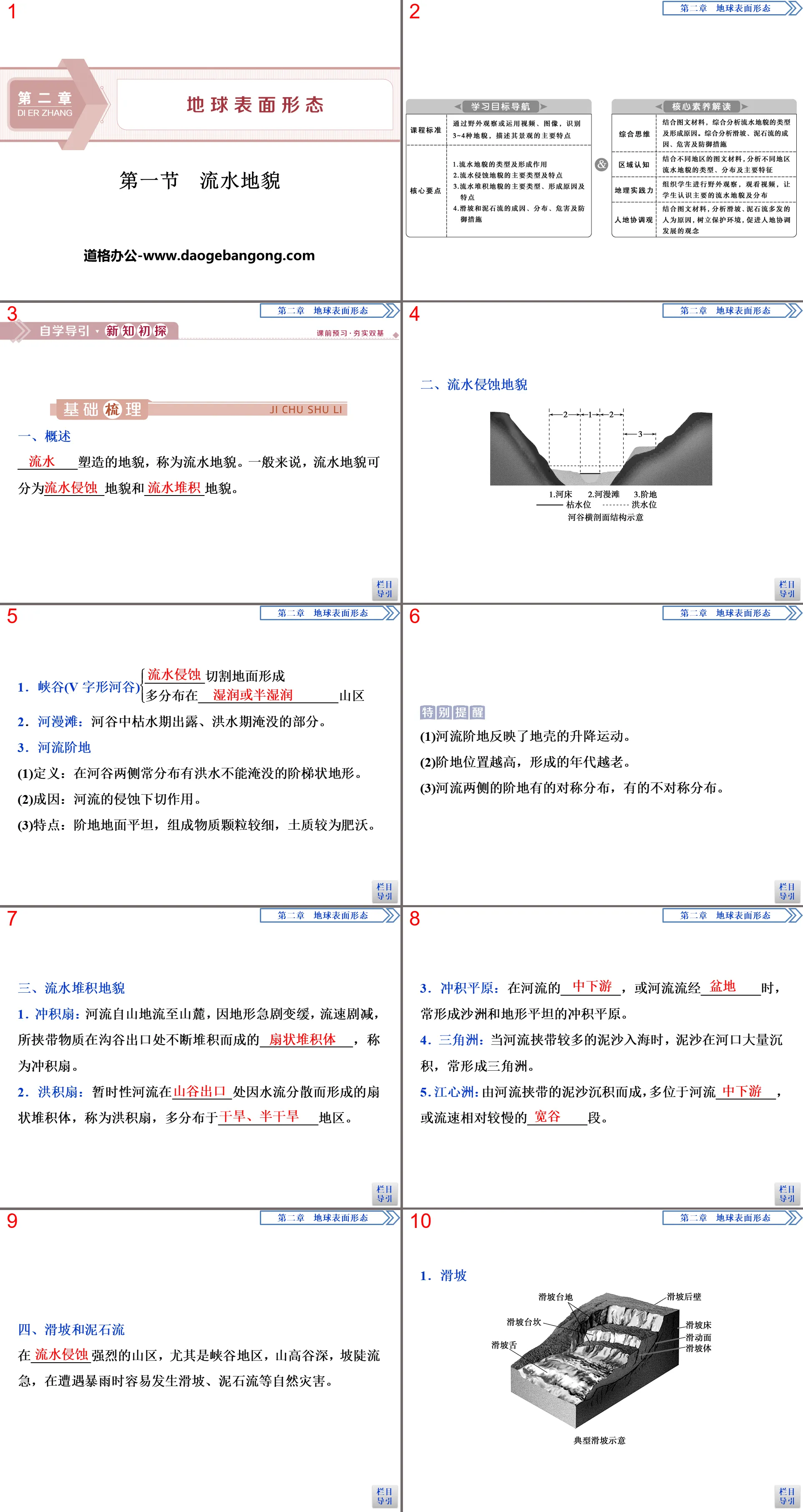
4. Landslides and mudslides
In mountainous areas with strong _________, especially in canyon areas, with high mountains and deep valleys, steep slopes and rapid flows, natural disasters such as landslides and mudslides are prone to occur during heavy rains.
1. landslide
(1) Definition: The phenomenon of a large amount of mountain material sliding along the _________ under the action of gravity.
(2)Hazard
① Buried farmland and villages
② Block roads and other infrastructure
③siltation of river channels to form barrier lakes
④ Causing casualties and property losses
2. mudslide
(1) Definition: Mountain ________ contains a large amount of mixture of solid debris material and water. It is a special fluid that flows downward along the ditch bed under the action of gravity.
(2)Hazard
①Wash away towns, villages, factories, etc.
② Destroy crops, forests and cultivated land
③ Silt up rivers and cause floods
④ Causing casualties and property losses
(3)Defensive measures
①Do not stay in the ravine during continuous rain or heavy rain.
②Do not hide in a big tree, as the tree may be knocked down.
③ Quickly dodge to both sides of the debris flow ditch, and remember not to run down the ditch.
④ If a debris flow is discovered, it must be reported promptly so that residents downstream and at the mouth of the ditch can evacuate in time.
Flowing water landform PPT, part 2: independent evaluation
1. Judgment questions
1. Water erosion landforms only exist in the upper reaches of rivers. ()
2. The river bed is a trough-shaped depression where the river carries water and sediment, and does not change with the rise and fall of the water level. ()
3. The meanders of rivers have both river erosion and river accumulation. ()
4. Arid and semi-arid areas do not develop river accumulation landforms. ()
5. Landslides and mudslides occur in valleys. ()
2. Multiple choice questions
6. Among the following landforms, the one usually formed at the mouth of a river is ()
A. V-shaped valley B. Fall
C. delta d. alluvial fan
7. This test is most likely to simulate ()
A. Formation of sandy beaches on the coast
B. Formation of sand dunes in desert areas
C. The formation of alluvial fans in the foothills
D. formation of volcano
8. The landforms and landscapes similar to those in the picture above are ()
A. Yellow River Delta B. Danxia Mountain in Shaoguan, Guangdong
C. Elephant Trunk Hill, Guilin, Guangxi D. Guizhou Huangguoshu Waterfall
9. The areas prone to earthquakes, landslides, and debris flows in my country are ()
A. Northeastern region B. North-west region
C. Southeast region D. Southwest Region
Flowing water landform PPT, the third part: teacher-student interaction
river landforms
[Scenario introduction temptation]
Read the material and explore the following questions.
Material 1: The picture below is a schematic diagram of river development. River cross-sections ①②③ are cross-sections at three points a, b, and c on the river respectively (not one-to-one correspondence).
Material 2: The picture below shows a single-side cross-section of the upper reaches of a river. There are four flat surfaces T0, T1, T2, and T3 with different altitudes on both sides of this river section. River sedimentary gravels are accumulated on the flat surfaces. The average gravel diameter of gravel is T3>T0>T2>T1. During the flood period, the river water can only submerge T0.
(1) What are the main manifestations of external forces in the three river sections a, b, and c in the picture?
(2) According to the development process and characteristics of the river, connect the three points a, b, and c with the corresponding profile.
(3) A port authority plans to build a port at A and B near river section C. It is trying to analyze which location is more suitable. Why?
(4) The landform formed at the mouth of a river is ________. How was it formed?
(5) Based on Material 2, analyze the order in which the four terraces T0, T1, T2, and T3 are formed, and the velocity of the water flow when they are formed.
Tips: (1) They are erosion, transportation and accumulation.
(2) Draw a sketch. (Hint: a—②, b—③, c—①)
(3)A place. Point A is a concave bank of the river, where the erosion of flowing water is significant, and the river bed is deep, which is conducive to building a port; while point B is a convex bank of the river, where running water accumulates, and the river bed is shallow, which is not conducive to building a port.
(4) Delta: Rivers carry a large amount of sediment and flow through plain areas. The flow rate slows down, and coupled with the support of sea water, a large amount of sediment is deposited at the river mouth to form a delta.
(5) The four terraces formed from early to late are T3, T2, T1, and T0. When four terraces are formed, the speed of the water flow from large to small is T3, T0, T2, and T1.
[Breakthrough in core test points]
1. river erosion landforms
River valleys are developed from ravines, and have gone through the process from ravines to V-shaped valleys, and then to trough-shaped valleys. At different development stages, the forms of river erosion are different from the valley morphology. As shown below:
2. Different river accumulation landforms and their impacts
The accumulation landforms of rivers include three common types: flood-alluvial plains, flood plains and deltas, with different formation mechanisms and landform types. The details are shown in the following table:
3. Concave and convex banks of rivers
(1) Judgment of concave bank and convex bank (as shown below)
(2) Causes of river concave bank erosion and convex bank accumulation
When a river flows through a bend, the water moves in a curve to produce centrifugal force. Under the action of centrifugal force, the surface water flow tends to the concave bank and washes the concave bank, making the water surface on the concave bank slightly higher than the convex bank. Therefore, the bottom water flow flows from the concave bank to the convex bank under the action of pressure, forming a curved circulation. Under the influence, the concave bank erodes and the convex bank accumulates, as shown in the figure below:
(3) Application of concave and convex banks
[Point tracking training]
Alluvial fans and deltas are important landforms formed by river action. Answer questions 1-2 accordingly.
1. Which of the following statements about the distribution locations of alluvial fans and deltas is correct ()
①Alluvial fans are only distributed in arid and semi-arid areas
② Deltas are only distributed in humid and semi-humid areas
③The alluvial fan is located near the mouth of the river.
④The delta is located near the mouth of the river into the sea or the lake.
A. ①②B. ③④
C. ②④ D. ①③
2. Compared with alluvial fans, delta areas ()
①The terrain is flat and there are few branch currents ②The wave action is obvious
③The soil is fertile and the climate is mild. ④There are many sandbars and sand islands developed.
A. ①② B. ③④
C. ②④ D. ①③
landslides and mudslides
[Scenario introduction temptation]
Read the material and explore the following questions.
Material 1: Distribution map of landslide and debris flow disasters in China.
Material 2: Monthly distribution map of major collapses, landslides, and debris flow disasters across the country in 2014.
(1) Combined with Material 1, explain the spatial distribution characteristics and causes of geological disasters such as debris flows and landslides in my country.
(2) Combined with Material 2, explain the characteristics and causes of time distribution of geological disasters such as debris flows and landslides in my country.
(3) What kind of areas are prone to landslides?
Tips: (1) From a spatial perspective, my country's debris flows and landslides are mainly distributed in Sichuan, Yunnan, Guizhou, and Tibet in the southwest, Shaanxi, Gansu, and Shanxi in the northwest, as well as Fujian, Hunan, Hubei and other regions in the central and southeast. . Its basic characteristic is that there are more debris flows in the western region than in the eastern region, and more in the southern region than in the northern region. Among them, the southwest region of my country is the area where debris flows and landslides are most concentrated and occur with the highest frequency.
Causes of formation: large terrain undulations, strong tectonic activity, developed faults, broken rocks; severe weathering; concentrated precipitation, frequent heavy rains; unreasonable human engineering activities, such as cutting slopes to build roads, mining, cutting slopes to build houses, reservoir storage and Artificial soil removal and other damage to vegetation.
(2) From a time perspective, landslides and debris flows mainly occur from April to September; this is because local heavy rains and sustained heavy rainfall are the main triggers of geological disasters such as landslides and debris flows.
(3) Landslides generally occur in areas with relatively broken rock masses, large terrain undulations, and poor vegetation coverage. Mountains, hills and areas with frequent engineering construction are landslide-prone areas.
Flowing water landform PPT, the fourth part: improving literacy
Test point 1: River landforms
A valley is a trough-shaped depression formed by erosion by flowing water. The figure below shows the various stages of river valley development. Read the picture and answer questions 1-2.
1. According to the development process of the river valley, the correct order is ()
A. ③④①② B. ④③②①
C. ②①③④ D. ②①④③
2. The correct combination of main external forces in the upper, middle and lower reaches of the river is ()
A. Erosion-Transportation-Deposition
B. Erosion-deposition-transportation
C. Deposition-erosion-transportation
D. transport-erosion-deposition
3. The external forces that form the estuary delta are mainly ()
A. Water transportation B. wave accumulation
C. Accumulation of running water D. Wind handling
4. Among the following landforms, the one with the same cause as the formation of this estuary delta is ()
A. Piedmont alluvial fan B. Mount Fuji
C. The ravines of the Loess Plateau D. Karst
Test Point 2: Landslides and Debris Flows
5. read the article, answer the questions below.
Material: Distribution map of common geological hazards in southwest my country.
(1) Briefly describe the natural causes of frequent earthquakes and debris flow disasters in the area from the aspects of crustal movement, climate and the correlation between disaster causes.
(2) Briefly describe the man-made reasons for the frequent occurrence of debris flows in this area.
(3) Briefly describe the hazards of debris flow.
Answer: (1) The crustal activity in this area is strong and earthquakes occur frequently, resulting in the development of mountain fractures, broken rocks, and severe weathering. Heavy rains in the rainy season are concentrated, resulting in frequent debris flow disasters.
(2) Human damage to vegetation.
(3) Wash away and submerge farmland, villages and towns, causing casualties; destroy transportation lines and other infrastructure; cause economic losses.
Keywords: Hunan Education Edition high school geography compulsory course 1 PPT courseware free download, flowing water landform PPT download, earth surface form PPT download, .PPT format;
For more information about the PPT courseware "Earth's Surface Forms and Flowing Waters and Landforms", please click on the Earth's Surface Forms ppt Flowing Waters and Landforms ppt tag.
"Aeolian Landform" Earth's surface form PPT:
"Aeolian Landforms" Earth's Surface Formation PPT Part One Content: Strengthening the Implementation of Basic Knowledge [Key Points for Filling in Self-Reading Textbooks] 1. Wind Effect 1. Region: arid and semi-arid areas. 2. Types of landforms formed: _____ landforms and _____ landforms. 2. Wind-eroded landforms..
"Flowing Water Landform" Earth surface form PPT courseware:
"Flowing Water Landforms" Earth Surface Forms PPT Courseware Part One Content: Course Standards: Through field observation or the use of videos and images, identify 3 to 4 landforms and describe the main characteristics of their landscapes. Literacy goals: 1. Be able to identify the types of river landforms in different reaches of the basin..
"Flowing Water Landform" Earth's surface form PPT:
"Flowing Water Landform" Earth's Surface Formation PPT Part One: Strengthening the Implementation of Basic Knowledge [Key Points for Filling in Self-Reading Textbooks] 1. Landform eroded by flowing water 1. Canyon (1) Distribution area: ____ or ____ mountainous areas. (2) Formation: The flowing water ____ cuts the ground to form. (3)Shape..
File Info
Update Time: 2024-09-30
This template belongs to Geography courseware Hunan Education Edition High School Geography Compulsory Course I industry PPT template
"Flowing Water Landform" Earth's surface form PPT download Simple campus recruitment activity planning plan summary enterprise and institution recruitment publicity lecture PPT template is a general PPT template for business post competition provided by the manuscript PPT, simple campus recruitment activity planning plan summary enterprise and institution recruitment promotion Lecture PPT template, you can edit and modify the text and pictures in the source file by downloading the source file. If you want more exquisite business PPT templates, you can come to grid resource. Doug resource PPT, massive PPT template slide material download, we only make high-quality PPT templates!
Tips: If you open the template and feel that it is not suitable for all your needs, you can search for related content "Flowing Water Landform" Earth's surface form PPT download is enough.
How to use the Windows system template
Directly decompress the file and use it with office or wps
How to use the Mac system template
Directly decompress the file and use it Office or wps can be used
Related reading
For more detailed PPT-related tutorials and font tutorials, you can view: Click to see
How to create a high-quality technological sense PPT? 4 ways to share the bottom of the box
Notice
Do not download in WeChat, Zhihu, QQ, built-in browsers, please use mobile browsers to download! If you are a mobile phone user, please download it on your computer!
1. The manuscript PPT is only for study and reference, please delete it 24 hours after downloading.
2. If the resource involves your legitimate rights and interests, delete it immediately.
3. Contact information: service@daogebangong.com
"Flowing Water Landform" Earth's surface form PPT download, due to usage restrictions, it is only for personal study and reference use. For commercial use, please go to the relevant official website for authorization.
(Personal non-commercial use refers to the use of this font to complete the display of personal works, including but not limited to the design of personal papers, resumes, etc.)
Preview
Related Search:
"Flowing Water Landform" Earth's surface form PPT download
2024-09-30
Copyright statement: This material is compiled and released by the user of Daoge Resources. The copyright belongs to the author. For commercial use, please contact the copyright owner. If there is any infringement, please contact the webmaster to remove the resource.
Download Points: 0.00
Free Download
Upgrade VIP
Favorite
Views: 1728 / Downloads: 727


