Business Planet Edition 7th Grade Geography Volume 2
Business Planet Edition Geography for Grade 8 Volume 1
Business Planet Edition 7th Grade Geography Volume 1
People's Education Edition Geography for Seventh Grade Volume 2
Shanghai Education Edition Seventh Grade Geography Volume 1
Business Planet Edition Geography for Eighth Grade Volume 2
Hunan Education Edition High School Geography Compulsory Course I
People's Education Edition Geography for Grade 7 Volume 1
People's Education Edition Geography for Eighth Grade Volume 2
Lu Ke version of high school geography compulsory course I
Shanghai Education Edition Geography for Sixth Graders Volume 1
Hunan Education Edition High School Geography Compulsory Course II
Shanghai Education Edition Seventh Grade Geography Volume 2
People's Education Edition Geography for Grade 8 Volume 1
Compulsory Course 1 of High School Geography in China Graphics Edition
People's Education Press High School Geography Compulsory Course 1

| Category | Format | Size |
|---|---|---|
| Hunan Education Edition High School Geography Compulsory Course I | pptx | 6 MB |

"Flowing Water Landform" Earth Surface Form PPT Courseware
2024-10-01
Copyright statement: This material is compiled and released by the user of Daoge Resources. The copyright belongs to the author. For commercial use, please contact the copyright owner. If there is any infringement, please contact the webmaster to remove the resource.
Download Points: 0.00
Free Download
Upgrade VIP
Favorite
Views: 3499 / Downloads: 209
Description
"Flowing Water Landform" Earth Surface Form PPT Courseware
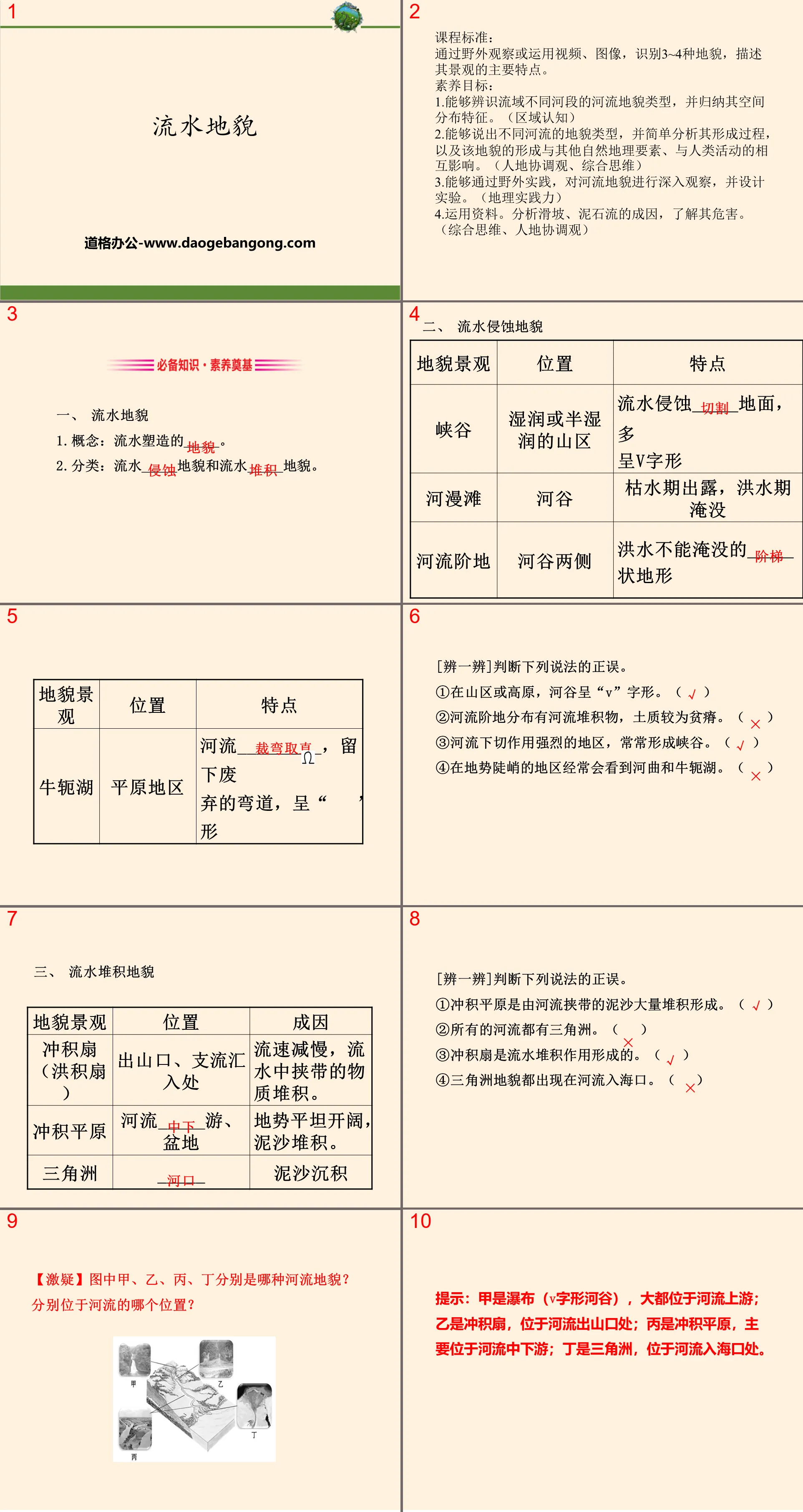
Part One Content: Curriculum Standards:
Through field observation or the use of videos and images, identify 3 to 4 types of landforms and describe the main characteristics of their landscapes.
Literacy goals:
1. Be able to identify river landform types in different river sections of the basin and summarize their spatial distribution characteristics. (regional awareness)
2. Be able to name the landform types of different rivers, and briefly analyze their formation process, as well as the interaction between the formation of this landform, other natural geographical elements, and human activities. (Coordinated view of man and earth, comprehensive thinking)
3. Be able to conduct in-depth observations of river landforms and design experiments through field practice. (geographical practice)
4. Use data. Analyze the causes of landslides and debris flows and understand their hazards. (Comprehensive thinking, man-land coordination view)
Flowing water landform PPT, the second part of the content: essential knowledge and literacy foundation
1. Flowing water landforms
1. Concept: _____ shaped by running water.
2. Classification: flowing water _____ landform and flowing water _____ landform.
2. Landforms eroded by running water
[Discriminate]Determine whether the following statements are true or false.
①In mountainous areas or plateaus, river valleys are in a "V" shape. ( )
②The river terraces are distributed with river deposits and the soil quality is relatively poor. ( )
③Canyons are often formed in areas where river incision is strong. ( )
④Meanders and oxbow lakes are often seen in areas with steep terrain. ( )
3. Water accumulation landform
[Discriminate]Determine whether the following statements are true or false.
①Alluvial plains are formed by the accumulation of large amounts of sediment carried by rivers. ( )
②All rivers have deltas. ( )
③Alluvial fans are formed by the accumulation of flowing water. ( )
④ Delta landforms all appear at the mouths of rivers. ( )
4. Landslides and debris flows
1. Landslide:
(1) Concept: The phenomenon that a large amount of _____ matter slides along the _______ as a whole under the action of gravity.
(2) Harm: bury___________, block roads, block _____, resulting in casualties and property losses.
2. Debris flow:
(1) Concept: Mountain valleys contain a mixture of large amounts of solid ___________, a special fluid that flows downward along _____ under the action of gravity.
(2) Harm: It brings great harm to industrial and agricultural production, ________, urban construction and people ________.
[Discriminate]Determine whether the following statements are true or false.
① Water must be involved in the occurrence of landslides. ( )
② One of the common characteristics of areas prone to landslides and debris flows is the large terrain undulations. ( )
③Landslides and debris flow disasters occur frequently in the eastern coastal areas of my country. ( )
Flowing water landform PPT, the third part: key capabilities and literacy formation
Ability 1: Describe the landscape characteristics of river landforms
1. Landscape characteristics of river landforms:
2. Development of river landforms:
(1) River erosion landform - the development process of river valleys.
(2) The formation process of river accumulation landforms.
(3) Erosion and sedimentation of river bends.
When a river flows through a bend, the water flows toward the concave bank, while the water at the bottom flows from the concave bank to the convex bank. Under the action of flowing water, the concave bank erodes and the convex bank accumulates (as shown in the figure).
[Ideas] Describe it from the perspective of shape, terrain changes, sediment particle changes, etc.
[Analysis] Answer based on the plane shape of the alluvial fan in the picture, the topography in the cross-section, and the changes in particulate matter. The text labels "fan top" and "fan edge" in the picture should also be used.
Answer: It is fan-shaped with the valley mouth as the vertex. From the top of the fan to the edge of the fan, the terrain changes from high to low, the sediments change from thick to thin, and the particles change from coarse to fine.
【Literacy Research】
Picture a shows the Lancang-Mekong River Basin, picture b shows the landscape at the confluence of the tributaries of the Lancang River, and picture c shows a satellite image of a certain landform.
(1) (Comprehensive thinking, regional cognition) Name the landform type shown in Figure b, and analyze the changing characteristics of slope and sediment particle size.
Hint: alluvial fan. From the fan top to the fan edge, the slope gradually becomes smaller and the sediment particles change from coarse to fine.
(2) (Comprehensive thinking, geographical practice ability) Explain the formation process of the landform shown in Figure c.
Tip: When a river flows into the ocean, its flow rate slows down, and the sediment it carries is deposited at the river mouth.
Ability 2: Analyze the causes of landslides and debris flow disasters
1. Causes of landslide and debris flow disasters:
forming conditions
landslide
①Geological and terrain conditions: It generally occurs in mountainous areas with relatively broken rock masses and large terrain undulations. ②Surface vegetation conditions: Vegetation coverage is poor. ③Climate conditions: humid and semi-humid areas with abundant precipitation and large precipitation variability.
mudslide
①The terrain is steep; ②It has abundant loose materials;
③There is a large amount of water flow in a short period of time.
[Typical example demonstration]
Read "Distribution Map of Earthquakes, Debris Flows and Other Geological Hazards in Southwest my country" and complete questions (1) and (2).
(1) In the analysis of the causes of frequent geological disasters in this area, what is unreasonable is ()
A. Located at the junction of plates, the modern crust is active
B. The terrain is complex and the mountain slope is steep
C. The dry and wet seasons are distinct and heavy rains are concentrated.
D. The temperature varies greatly from day to day and the rocks are broken.
(2) Human activities may also induce geological disasters, such as destroying vegetation, which is most likely to cause ()
A.earthquake
B. Mudslide
C. Volcanic eruption
D.Collapse
[Idea Tip] Answering this type of questions mainly starts from the following two points:
(1) Analyze the crustal movement, terrain relief and precipitation conditions of the area based on materials or regional maps to determine prone geological hazards.
(2) Analyze natural disasters that may be induced by human activities based on the causes of earthquakes, landslides, mudslides, volcanic eruptions and other disasters.
Keywords: Hunan Education Edition high school geography compulsory course 1 PPT courseware free download, flowing water landform PPT download, earth surface form PPT download, .PPT format;
For more information about the PPT courseware "Flowing Water Landform Earth Surface Form", please click the "Flowing Water Landform ppt Earth Surface Form ppt" tag.
"Flowing Water Landform" Earth's surface form PPT download:
"Flowing Water Landform" PPT download of the earth's surface form Part One: Basic review 1. Overview The landform shaped by _________ is called flowing water landform. Generally speaking, flowing water landforms can be divided into ________ landforms and ________ landforms. 2. Landforms eroded by flowing water..
"Flowing Water Landform" Earth's surface form PPT:
"Flowing Water Landform" Earth's Surface Formation PPT Part One: Strengthening the Implementation of Basic Knowledge [Key Points for Filling in Self-Reading Textbooks] 1. Landform eroded by flowing water 1. Canyon (1) Distribution area: ____ or ____ mountainous areas. (2) Formation: The flowing water ____ cuts the ground to form. (3)Shape..
"Landscape Characteristics of Main Landforms" Natural Geographic Elements and Phenomenon PPT (Flowing Water Landforms and Coastal Landforms in the First Lesson):
"Landscape Characteristics of Main Landforms" Natural Geographic Elements and Phenomenon PPT (Flowing Water Landforms and Coastal Landforms in the First Lesson) Part One Content: Strengthening the Implementation of Basic Knowledge [Key Points for Filling in Self-Reading Textbooks] 1. Landform 1. Concept: It is a general term for various ______ on the earth’s surface. 2. ..
File Info
Update Time: 2024-10-01
This template belongs to Geography courseware Hunan Education Edition High School Geography Compulsory Course I industry PPT template
"Flowing Water Landform" Earth Surface Form PPT Courseware Simple campus recruitment activity planning plan summary enterprise and institution recruitment publicity lecture PPT template is a general PPT template for business post competition provided by the manuscript PPT, simple campus recruitment activity planning plan summary enterprise and institution recruitment promotion Lecture PPT template, you can edit and modify the text and pictures in the source file by downloading the source file. If you want more exquisite business PPT templates, you can come to grid resource. Doug resource PPT, massive PPT template slide material download, we only make high-quality PPT templates!
Tips: If you open the template and feel that it is not suitable for all your needs, you can search for related content "Flowing Water Landform" Earth Surface Form PPT Courseware is enough.
How to use the Windows system template
Directly decompress the file and use it with office or wps
How to use the Mac system template
Directly decompress the file and use it Office or wps can be used
Related reading
For more detailed PPT-related tutorials and font tutorials, you can view: Click to see
How to create a high-quality technological sense PPT? 4 ways to share the bottom of the box
Notice
Do not download in WeChat, Zhihu, QQ, built-in browsers, please use mobile browsers to download! If you are a mobile phone user, please download it on your computer!
1. The manuscript PPT is only for study and reference, please delete it 24 hours after downloading.
2. If the resource involves your legitimate rights and interests, delete it immediately.
3. Contact information: service@daogebangong.com
"Flowing Water Landform" Earth Surface Form PPT Courseware, due to usage restrictions, it is only for personal study and reference use. For commercial use, please go to the relevant official website for authorization.
(Personal non-commercial use refers to the use of this font to complete the display of personal works, including but not limited to the design of personal papers, resumes, etc.)
Preview
Related Search:
"Flowing Water Landform" Earth Surface Form PPT Courseware
2024-10-01
Copyright statement: This material is compiled and released by the user of Daoge Resources. The copyright belongs to the author. For commercial use, please contact the copyright owner. If there is any infringement, please contact the webmaster to remove the resource.
Download Points: 0.00
Free Download
Upgrade VIP
Favorite
Views: 3499 / Downloads: 209


