Business Planet Edition 7th Grade Geography Volume 2
Business Planet Edition Geography for Grade 8 Volume 1
Business Planet Edition 7th Grade Geography Volume 1
People's Education Edition Geography for Seventh Grade Volume 2
Shanghai Education Edition Seventh Grade Geography Volume 1
Business Planet Edition Geography for Eighth Grade Volume 2
Hunan Education Edition High School Geography Compulsory Course I
People's Education Edition Geography for Grade 7 Volume 1
People's Education Edition Geography for Eighth Grade Volume 2
Shanghai Education Edition Geography for Sixth Graders Volume 1
Lu Ke version of high school geography compulsory course I
Hunan Education Edition High School Geography Compulsory Course II
Shanghai Education Edition Seventh Grade Geography Volume 2
People's Education Edition Geography for Grade 8 Volume 1
Compulsory Course 1 of High School Geography in China Graphics Edition
People's Education Press High School Geography Compulsory Course 1

| Category | Format | Size |
|---|---|---|
| Business Planet Edition Geography for Eighth Grade Volume 2 | pptx | 6 MB |

"Division of China's Four Major Geographic Regions" PPT courseware
2024-09-18
Copyright statement: This material is compiled and released by the user of Daoge Resources. The copyright belongs to the author. For commercial use, please contact the copyright owner. If there is any infringement, please contact the webmaster to remove the resource.
Download Points: 0.00
Free Download
Upgrade VIP
Favorite
Views: 2560 / Downloads: 493
Description
"Division of China's Four Major Geographic Regions" PPT courseware
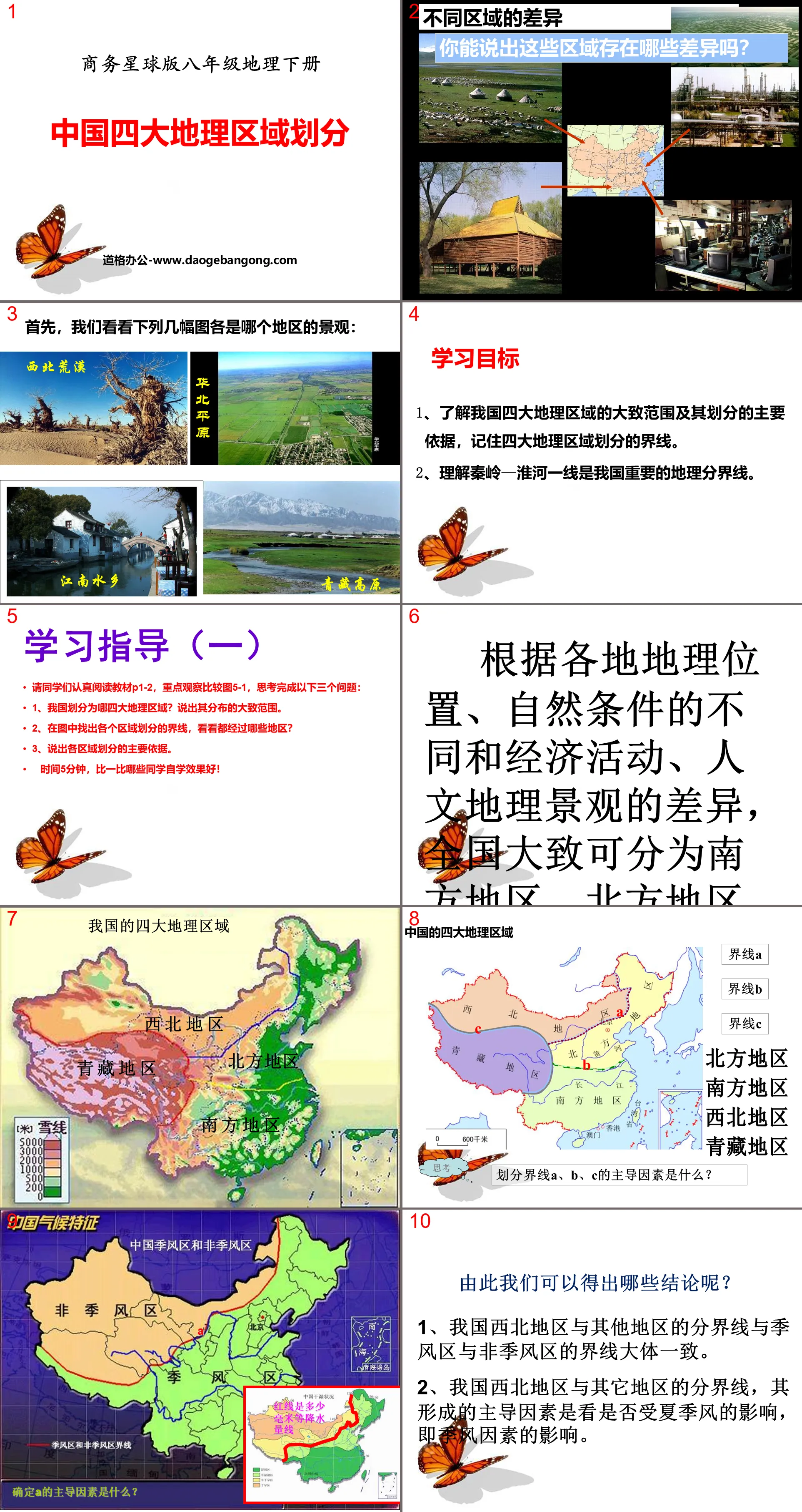
learning target
1. Understand the general scope of my country's four major geographical regions and the main basis for their division, and remember the boundaries of the four major geographical regions.
2. Understand that the Qinling Mountains-Huaihe River line is an important geographical dividing line in my country.
Study Guide (1)
Please read the textbook P1-2 carefully, focus on observing and comparing Figure 5-1, and think about and answer the following three questions:
1. What are the four major geographical regions that my country is divided into? State the approximate range of its distribution.
2. Find the boundaries of each area on the map and see which areas they pass through?
3. State the main basis for dividing each region.
Time is 5 minutes. Compare which students are better at self-study!
According to differences in geographical location, natural conditions, economic activities, and cultural and geographical landscapes, the country can be roughly divided into the southern region, the northern region, the northwest region and the Qinghai-Tibet region.
What conclusions can we draw from this?
1. The boundary between northwest my country and other regions is generally consistent with the boundary between monsoon and non-monsoon areas.
2. The dominant factor in forming the dividing line between northwest my country and other regions is whether it is affected by the summer monsoon, that is, the monsoon factor.
Comparing the pictures above, what conclusions can we draw?
1. The dividing line between northern and southern my country is roughly consistent with the January 0° isotherm, the 800mm isotherm line in my country, and the Qinling-Huaihe line.
2. Its dominant factors are related to temperature and precipitation, that is, climate factors.
Study Guide (2)
Please read the textbook P3 carefully and think about the following questions:
1. Draw the Qinling Mountains-Huaihe River line in the picture and compare the geographical differences between the north and south sides.
2. Combined with the image content, describe the geographical significance of the Qinling-Huaihe line.
Time: 5 minutes. Compare which students finish better!
The geographical significance of the Qinling Mountains and the Huaihe River line
1. Temperature
1. 0℃ isotherm in January
2. The dividing line between warm temperate zone and subtropical zone
2. Precipitation
3. Precipitation line with annual precipitation of 800mm
4. The dividing line between humid areas and semi-humid areas
3. Climate
5. The dividing line between subtropical monsoon climate and temperate monsoon climate
4. Agriculture
6. The dividing line between dryland agriculture and paddy field agriculture
7. The dividing line between rice production and wheat production
5. Vegetation
8. The dividing line between evergreen broad-leaved forest and deciduous broad-leaved forest
6. River
9. The Qinling Mountains (and Bayan Har Mountain) are also the watershed between the Yangtze River and the Yellow River
10. The river north of this line has small flow, large water level changes, and ice periods.
Rivers south of this line have large flows, small water level changes, and no ice periods.
Class exercises:
1. A certain mountain range in my country is dominated by dry land to the north and paddy fields to the south. The correct statement about the direction of this mountain range is ( )
A North-south direction B Northeast-southwest direction
C east-west direction D east-west direction
2. Shandong Province is located in my country ( )
ANorthern region BSouthern region CNorthwestern region DQinghai-Tibet region
3. The Qinling Mountains-Huaihe River line is roughly ( )
A The place where the 400 mm constant precipitation line passes
B The place where the 0°C isotherm passes through
C The dividing line between monsoon and non-monsoon areas
D The boundary between the inner flow area and the outer flow area
4. The following terrain areas are located south of the Qinling Mountains-Huaihe River line ( )
A North China Plain B Sichuan Basin C Loess Plateau D Qaidam Basin
5. There is no obvious difference between the north and south sides of the Qinling-Huaihe River line ( )
A Natural environment B Geographical landscape C Residents’ staple food D Race and religion
6. The boundaries of my country’s four major geographical regions do not include ( )
A Qinling-Huaihe line B 400 mm constant precipitation line
C Tibetan Plateau edge line D 200 mm constant precipitation line
Outward training:
1. Type of cultivated land: South ( ) North ( )
2. Food crops: South ( ) North ( )
3. Sugar crops: South ( ) North ( )
4. Climate Disasters: South ( ) North ( )
5. Transportation: South ( ) North ( )
6. Eating habits: South ( ) North ( )
7. Industrial structure: South ( ) North ( )
8. Martial arts expertise: South ( ) North ( )
9. Dialect type: South ( ) North ( )
Keywords: Free download of Geography PPT courseware for the second volume of the eighth grade edition of Business Planet Edition, PPT download of the division of China's four major geographical regions, .PPT format;
For more information about the PPT courseware "China's Four Major Geographic Regions", please click on the China's Four Major Geographic Regions ppt tab.
"Division of China's Four Major Geographic Regions" PPT courseware download:
"Dividing China's Four Major Geographic Regions" PPT courseware download Part One: Learning Objectives 1. Understand the basis of my country's four major geographical regions, as well as the differences between natural landscapes and cultural landscapes. 2. Understand the Qinling Mountains and the Huaihe River, an important geographical dividing line in my country. The size of our country...
"Division of China's Four Major Geographic Regions" PPT download:
"Division of China's Four Major Geographic Regions" PPT Download Part One: Introduction of New Courses Our country has a vast territory and significant regional differences. From the forests and snowfields of Northeast China to the tropical scenery of Hainan Island; from the water towns of Jiangnan with dense river networks to the Qinghai-Tibet Plateau with rolling snow-capped mountains and herds of cattle and sheep...
"Division of China's Four Major Geographic Regions" PPT:
"China's Four Major Geographic Regions" PPT Part One Content: Learning Objectives 1. Find the Qinling Mountains and the Huaihe River on the map, and explain the geographical significance of the Qinling Mountains and the Huaihe River line. 2. Point out the four geographical units on the map: the northern region, the southern region, the northwest region, and the Qinghai-Tibet region.
File Info
Update Time: 2024-09-18
This template belongs to Geography courseware Business Planet Edition Geography for Eighth Grade Volume 2 industry PPT template
"Division of China's Four Major Geographic Regions" PPT courseware Simple campus recruitment activity planning plan summary enterprise and institution recruitment publicity lecture PPT template is a general PPT template for business post competition provided by the manuscript PPT, simple campus recruitment activity planning plan summary enterprise and institution recruitment promotion Lecture PPT template, you can edit and modify the text and pictures in the source file by downloading the source file. If you want more exquisite business PPT templates, you can come to grid resource. Doug resource PPT, massive PPT template slide material download, we only make high-quality PPT templates!
Tips: If you open the template and feel that it is not suitable for all your needs, you can search for related content "Division of China's Four Major Geographic Regions" PPT courseware is enough.
How to use the Windows system template
Directly decompress the file and use it with office or wps
How to use the Mac system template
Directly decompress the file and use it Office or wps can be used
Related reading
For more detailed PPT-related tutorials and font tutorials, you can view: Click to see
How to create a high-quality technological sense PPT? 4 ways to share the bottom of the box
Notice
Do not download in WeChat, Zhihu, QQ, built-in browsers, please use mobile browsers to download! If you are a mobile phone user, please download it on your computer!
1. The manuscript PPT is only for study and reference, please delete it 24 hours after downloading.
2. If the resource involves your legitimate rights and interests, delete it immediately.
3. Contact information: service@daogebangong.com
"Division of China's Four Major Geographic Regions" PPT courseware, due to usage restrictions, it is only for personal study and reference use. For commercial use, please go to the relevant official website for authorization.
(Personal non-commercial use refers to the use of this font to complete the display of personal works, including but not limited to the design of personal papers, resumes, etc.)
Preview
Related Search:
"Division of China's Four Major Geographic Regions" PPT courseware
2024-09-18
Copyright statement: This material is compiled and released by the user of Daoge Resources. The copyright belongs to the author. For commercial use, please contact the copyright owner. If there is any infringement, please contact the webmaster to remove the resource.
Download Points: 0.00
Free Download
Upgrade VIP
Favorite
Views: 2560 / Downloads: 493


