Business Planet Edition 7th Grade Geography Volume 2
Business Planet Edition Geography for Grade 8 Volume 1
Business Planet Edition 7th Grade Geography Volume 1
People's Education Edition Geography for Seventh Grade Volume 2
Shanghai Education Edition Seventh Grade Geography Volume 1
Business Planet Edition Geography for Eighth Grade Volume 2
Hunan Education Edition High School Geography Compulsory Course I
People's Education Edition Geography for Grade 7 Volume 1
People's Education Edition Geography for Eighth Grade Volume 2
Shanghai Education Edition Geography for Sixth Graders Volume 1
Lu Ke version of high school geography compulsory course I
Hunan Education Edition High School Geography Compulsory Course II
Shanghai Education Edition Seventh Grade Geography Volume 2
People's Education Edition Geography for Grade 8 Volume 1
Compulsory Course 1 of High School Geography in China Graphics Edition
People's Education Press High School Geography Compulsory Course 1

| Category | Format | Size |
|---|---|---|
| Business Planet Edition 7th Grade Geography Volume 1 | pptx | 6 MB |

"Interpretation of Topographic Maps" PPT
2024-10-02
Copyright statement: This material is compiled and released by the user of Daoge Resources. The copyright belongs to the author. For commercial use, please contact the copyright owner. If there is any infringement, please contact the webmaster to remove the resource.
Download Points: 0.00
Free Download
Upgrade VIP
Favorite
Views: 5022 / Downloads: 810
Description
"Interpretation of Topographic Maps" PPT
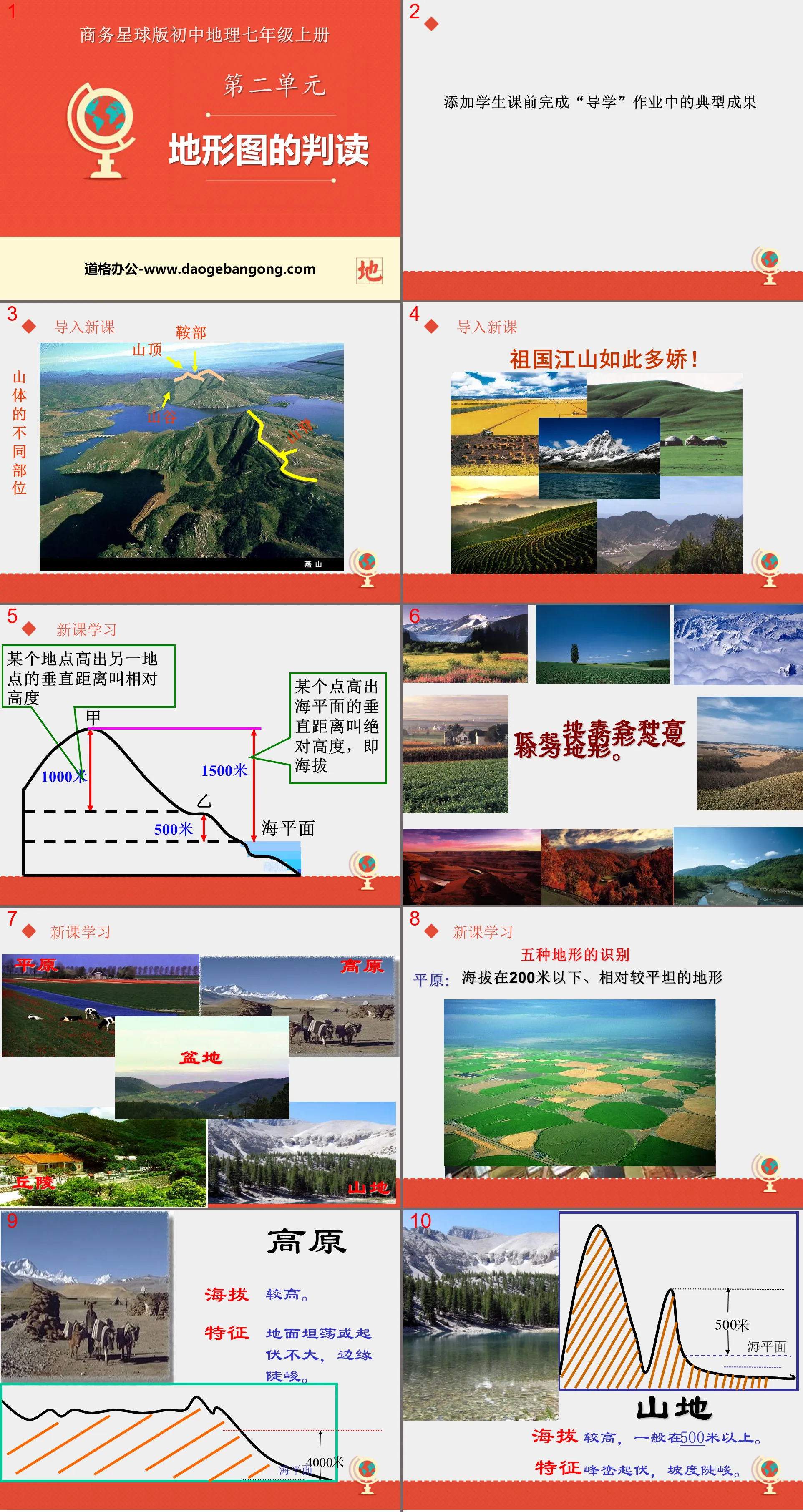
Part One Content: New Lesson Learning
The vertical distance between a location and another location is called relative height
The vertical distance of a point above sea level is called absolute height, that is, altitude
The various ups and downs on the earth's surface are collectively called terrain.
Identification of five types of terrain
Plain: Relatively flat terrain below 200 meters above sea level
plateau
The altitude is higher.
Characteristics: The ground is flat or has little undulations, and the edges are steep.
Mountain
The altitude is relatively high, generally above 500 meters.
Features: undulating peaks and steep slopes.
Part 2 content: Characteristics of contour lines:
1. Contour lines are closed curves.
2. All points on the same contour line have the same altitude.
3. Large value - high altitude
Small value - low altitude
4. Dense distribution - steep slope
Sparse distribution - gentle slope
Summit—The highest part of a mountain, where the contour values are greatest.
It is a closed curve, and the center value of the contour line is high. low all around
Ridge - The top of a mountain ridge, extending in a linear shape. Similar to the ridge of a house or the backbone of a horse's back.
The curved portion of the contour lines bulges downward (in the direction of smaller contour values).
Valley - A low-lying portion between ridges that extends in a linear pattern.
The curved part of the contour line bulges upward (in the direction of the larger contour value).
Saddle - The relatively low part between two adjacent mountain tops.
The middle section consists of a pair of contour lines.
Part Three: Knowledge Application
How to interpret mountains based on contour topographic maps
1. Read the value of each contour line
2. Determine the height and fluctuation of the ground based on numerical changes
3. Determine whether the slope is steep or gentle based on the density of contour lines.
4. Determine ridges and valleys based on the curvature of contour lines
How to use contour lines to determine terrain locations?
The value on the top of the mountain is high on the inside and low on the outside, forming a closed shape.
saddle between two mountain tops
steep cliff overlapping contours
Ridge Contour lines protrude from high to low
Valley contour lines protrude from low to high
Part 4 content: Classroom exercises
1. Which of the following descriptions of the five basic land topographic features is correct ( )
A. If the ground is broad and flat, it must be a plain.
B. The rolling ground must be mountainous
C. The plateau is relatively high, but the altitude is low
D. A basin is a terrain that is high on all sides and low in the middle.
2. The picture below is a schematic diagram of four contour terrains. The one that reflects the artistic conception of "an ancient temple hidden in the mountains" is ( )
3. The altitude of the top of the mountain in the picture may be ( )
A. 457 meters B. 400 meters C. 531 meters D. 398 meters
4. The terrain represented by the dotted line in the figure is ( )
A. Valley B. Saddle C. Mountain top D. ridge
5. The location with the serial number in the figure has the smallest slope ( )
A. ① B. ②C. ③D. ④
Keywords: Business Planet version seventh grade geography PPT courseware free download, topographic map interpretation PPT download, .PPT format;
For more information about the "Interpretation of Topographic Maps" PPT courseware, please click the Interpretation of Topographic Maps ppt tab.
"Interpretation of Topographic Maps" PPT download:
"Interpretation of Topographic Maps" PPT Download Part One: New Lesson Knowledge 1. Introduction of New Lessons Xiao Ming competed with TOM to climb Mount Tai. The smart TOM quickly climbed to the top of the mountain with the help of a map. Does anyone know what map it is? They faced Mount Tai from the foot of the mountain to the top...
"Interpretation of Topographic Maps" PPT courseware:
"Interpretation of Topographic Maps" PPT courseware Part 1: Learning objectives 1. What is the definition and calculation of altitude and relative altitude? 2. What is the definition of terrain? What are the five common types of terrain and their characteristics? 3. Identify the slope size and cliffs, peaks, saddles, mountains...
"Interpretation of Topographic Maps" Earth and Map PPT Courseware 8:
"Interpretation of Topographic Maps" Earth and Map PPT Courseware 8 This lesson aims to identify peaks, ridges, valleys, cliffs, saddles and other parts on contour topographic maps, and identify plateaus and mountains on layered color topographic maps. , plains, hills, basins and other basic terrains..
File Info
Update Time: 2024-10-02
This template belongs to Geography courseware Business Planet Edition 7th Grade Geography Volume 1 industry PPT template
"Interpretation of Topographic Maps" PPT Simple campus recruitment activity planning plan summary enterprise and institution recruitment publicity lecture PPT template is a general PPT template for business post competition provided by the manuscript PPT, simple campus recruitment activity planning plan summary enterprise and institution recruitment promotion Lecture PPT template, you can edit and modify the text and pictures in the source file by downloading the source file. If you want more exquisite business PPT templates, you can come to grid resource. Doug resource PPT, massive PPT template slide material download, we only make high-quality PPT templates!
Tips: If you open the template and feel that it is not suitable for all your needs, you can search for related content "Interpretation of Topographic Maps" PPT is enough.
How to use the Windows system template
Directly decompress the file and use it with office or wps
How to use the Mac system template
Directly decompress the file and use it Office or wps can be used
Related reading
For more detailed PPT-related tutorials and font tutorials, you can view: Click to see
How to create a high-quality technological sense PPT? 4 ways to share the bottom of the box
Notice
Do not download in WeChat, Zhihu, QQ, built-in browsers, please use mobile browsers to download! If you are a mobile phone user, please download it on your computer!
1. The manuscript PPT is only for study and reference, please delete it 24 hours after downloading.
2. If the resource involves your legitimate rights and interests, delete it immediately.
3. Contact information: service@daogebangong.com
"Interpretation of Topographic Maps" PPT, due to usage restrictions, it is only for personal study and reference use. For commercial use, please go to the relevant official website for authorization.
(Personal non-commercial use refers to the use of this font to complete the display of personal works, including but not limited to the design of personal papers, resumes, etc.)
Preview
Related Search:
"Interpretation of Topographic Maps" PPT
2024-10-02
Copyright statement: This material is compiled and released by the user of Daoge Resources. The copyright belongs to the author. For commercial use, please contact the copyright owner. If there is any infringement, please contact the webmaster to remove the resource.
Download Points: 0.00
Free Download
Upgrade VIP
Favorite
Views: 5022 / Downloads: 810


