| Category | Format | Size |
|---|---|---|
| Shanghai Education Edition Geography for Sixth Graders Volume 2 | pptx | 6 MB |

"Topography of the World" PPT courseware
Description
"Topography of the World" PPT courseware
Part One: Altitude and Terrain
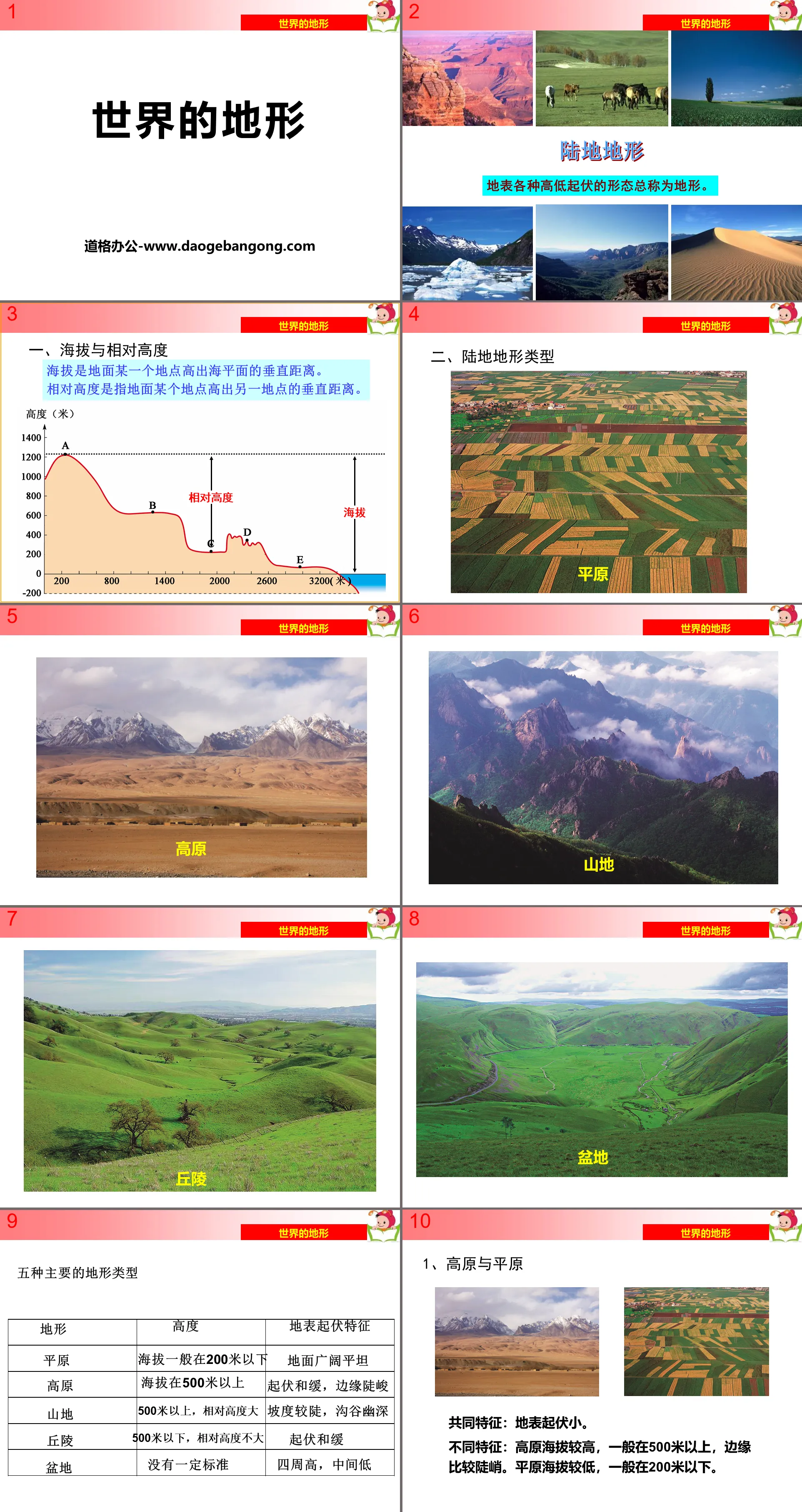
1. Altitude and relative altitude
Elevation is the vertical distance above sea level at a location on the ground.
Relative height refers to the vertical distance between one location on the ground and another location.
2. Land terrain types
1. Plateau and plain
Common features: The surface has small undulations.
Different characteristics: The plateau has a higher altitude, generally above 500 meters, and the edges are relatively steep. The plains have lower altitudes, generally below 200 meters.
2. Mountains and hills
Common features: The surface is rugged.
Different characteristics: higher mountains, mostly above 500 meters above sea level, with steep slopes and deep ravines. The hills are low, with an altitude of approximately below 500 meters, and the relative height generally does not exceed 200 meters.
3. Basin
The basin is mostly surrounded by mountains or plateaus, and the central part is relatively low and flat. There are also rolling hills distributed inside some basins.
Topography of the world PPT, part 2: contour lines
Concept: On a map, lines connecting points with equal altitudes on land are called contour lines.
Features:
① Contour lines are generally closed curves;
②The altitude on the same contour line is the same;
③The 0-meter contour generally represents sea level;
④Except for steep cliffs, contour lines at different altitudes do not intersect, overlap, or interrupt.
1. The meaning of contour lines and contour lines
Contour lines: Lines on a map that connect points on land with equal elevations.
Isobath: A line connecting points of the same depth in the ocean.
2. Contour lines in different parts of the mountainous area
High in the middle, low around the sides
lowland between two mountaintops
Low values convex to high values, with rivers developing
High values convex to low values
The topography of the world PPT, the third part: activities
Read the contour topographic map of a certain place and answer the following questions.
(1) Mark the top of the mountain, ridge, valley, saddle, and cliff on the picture.
(2) What is the altitude of point A? What is the relative height of points A and B in meters? How many meters do you estimate the altitude of top C to be?
(3) Starting from point A and point B, climb to the top of mountain C along the dotted line in the figure. Which climbing route is steeper? Please state the reasons for your judgment.
notes
1. Contour lines with low values convex to high values are valleys (where rivers develop), and high values convex to low values are ridges.
2. The steep cliffs are good for rock climbing and waterfall viewing.
3. The denser the contour lines, the steeper the slope; the sparser the contour lines, the gentler the slope.
Topography of the World PPT, Part 4: Classroom Exercises
1. Which of the following descriptions of the five basic land topographic features is correct ( )
A. If the ground is broad and flat, it must be a plain.
B. The rolling ground must be mountainous
C. The plateau is relatively high, but the altitude is low
D. A basin is a terrain that is high on all sides and low in the middle.
2. The picture below is a schematic diagram of four contour terrains. The one that reflects the artistic conception of "an ancient temple hidden in the mountains" is ( )
3. The altitude of the top of the mountain in the picture may be ( )
A. 457 meters B. 400 meters C. 531 meters D. 398 meters
4. The terrain represented by the dotted line in the figure is ( )
A. Valley B. Saddle C. Mountain top D. ridge
5. The location with the serial number in the figure has the smallest slope ( )
A. ① B. ②C. ③D. ④
Keywords: Free download of Geography PPT courseware for the second volume of the sixth grade of Shanghai Education Edition, PPT download of world terrain, .PPT format;
For more information about the "Topography of the World" PPT courseware, please click the "Topography of the World" ppt tag.
"Topography of the World" PPT:
"Topography of the World" PPT Part One Content: The course introduces professional geographical terms closely related to terrain. Altitude: the vertical distance of a point on the ground above sea level. Relative height: the vertical distance of a point on the ground above another point. Characteristics of plains and plateaus flat..
File Info
Update Time: 2024-06-29
This template belongs to Geography courseware Shanghai Education Edition Geography for Sixth Graders Volume 2 industry PPT template
"Topography of the World" PPT courseware Simple campus recruitment activity planning plan summary enterprise and institution recruitment publicity lecture PPT template is a general PPT template for business post competition provided by the manuscript PPT, simple campus recruitment activity planning plan summary enterprise and institution recruitment promotion Lecture PPT template, you can edit and modify the text and pictures in the source file by downloading the source file. If you want more exquisite business PPT templates, you can come to grid resource. Doug resource PPT, massive PPT template slide material download, we only make high-quality PPT templates!
Tips: If you open the template and feel that it is not suitable for all your needs, you can search for related content "Topography of the World" PPT courseware is enough.
How to use the Windows system template
Directly decompress the file and use it with office or wps
How to use the Mac system template
Directly decompress the file and use it Office or wps can be used
Related reading
For more detailed PPT-related tutorials and font tutorials, you can view: Click to see
How to create a high-quality technological sense PPT? 4 ways to share the bottom of the box
Notice
Do not download in WeChat, Zhihu, QQ, built-in browsers, please use mobile browsers to download! If you are a mobile phone user, please download it on your computer!
1. The manuscript PPT is only for study and reference, please delete it 24 hours after downloading.
2. If the resource involves your legitimate rights and interests, delete it immediately.
3. Contact information: service@daogebangong.com
"Topography of the World" PPT courseware, due to usage restrictions, it is only for personal study and reference use. For commercial use, please go to the relevant official website for authorization.
(Personal non-commercial use refers to the use of this font to complete the display of personal works, including but not limited to the design of personal papers, resumes, etc.)
Preview
Related Search: