Business Planet Edition 7th Grade Geography Volume 1
Business Planet Edition 7th Grade Geography Volume 2
Business Planet Edition Geography for Grade 8 Volume 1
People's Education Edition Geography for Seventh Grade Volume 2
People's Education Edition Geography for Eighth Grade Volume 2
Shanghai Education Edition Seventh Grade Geography Volume 1
Hunan Education Edition High School Geography Compulsory Course I
Compulsory Course 1 of High School Geography in China Graphics Edition
People's Education Edition Geography for Grade 7 Volume 1
People's Education Edition Geography for Grade 8 Volume 1
Hunan Education Edition High School Geography Compulsory Course II
Shanghai Education Edition Geography for Sixth Graders Volume 1
People's Education Press High School Geography Compulsory Course 1
Lu Ke version of high school geography compulsory course I
Shanghai Education Edition Seventh Grade Geography Volume 2
Business Planet Edition Geography for Eighth Grade Volume 2

| Category | Format | Size |
|---|---|---|
| People's Education Edition Geography for Grade 8 Volume 1 | pptx | 6 MB |

"Territory" View China from the World PPT Courseware 2
2024-11-13
Copyright statement: This material is compiled and released by the user of Daoge Resources. The copyright belongs to the author. For commercial use, please contact the copyright owner. If there is any infringement, please contact the webmaster to remove the resource.
Download Points: 0.00
Free Download
Upgrade VIP
Favorite
Views: 4260 / Downloads: 396
Description
"Territory" View China from the World PPT Courseware 2
"Three-level administrative divisions"
Principle of division: to facilitate administrative management, economic development and national unity.
34 provincial administrative regions
23 provinces
5 autonomous regions
4 municipalities
2 special administrative regions
The most administrative district
The largest area is Xinjiang Uygur Autonomous Region
The widest range of longitudes: Inner Mongolia Autonomous Region
Hainan has the widest latitude
The lowest latitude is Hainan
The highest latitude is Heilongjiang Province
Xinjiang Uygur Autonomous Region has the most land neighbors
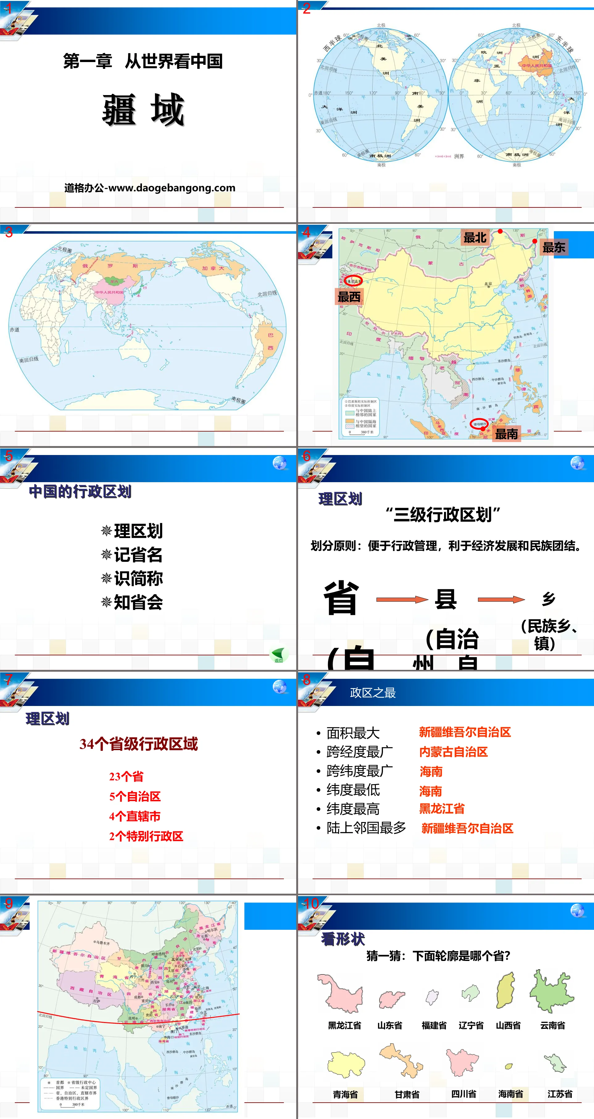
Look at the shape
Guess: Which province is the outline below?
Find out: Which provinces are the neighbors of the following provinces?
Please find the Yellow River and the Yangtze River, and tell us which provinces the Yellow River and the Yangtze River pass through?
Which province does the following cuisine come from? Do you know which cuisines are related to the abbreviation of the province?
Four major cuisines: Shandong cuisine, Cantonese cuisine, Jiangsu cuisine, and Sichuan cuisine
Which province does the following opera come from? Do you know which operas are related to the abbreviation of the province?
Peking Opera, Sichuan Opera, Henan Opera
Evaluation area
1. Which of the following statements about my country’s geographical location is correct ( )
A. The Tropic of Cancer passes through the south, and the Arctic Circle passes through the northern part of our country.
B. Most are in the southern temperate zone, a small part is in the tropics, and there is no cold zone
C. Our country is located in both the Eastern and Northern Hemispheres
D. China is a country in western Asia and on the east coast of the Pacific Ocean
2. Regarding the position evaluation of our country, which one is incorrect ( )
A. The north and south span a wide latitude and have large climate differences, which provide favorable conditions for the development of a variety of agricultural economies in my country.
B. The vast sea area facilitates the development of my country’s maritime industry and international trade.
C. The land territory goes deep into the Eurasian continent, which facilitates the development of border trade between my country and many land neighboring countries.
D. All of our country’s territory is located in the northern temperate zone, which is mild and rainy, conducive to agricultural production.
3. Our country has a vast territory, with a distance of more than 5,500 kilometers from north to south and nearly 50 degrees of latitude, resulting in ( )
4. During the summer vacation, Xiao Ming is going to the Turpan Basin in the Tianshan Mountains to see the magical landforms of the Flame Mountains. But Xiaoli wants to know the colorful ethnic customs. Please help them choose the combination of provincial administrative regions they want to go to, preferably ()
A. ①③ B. ①② C. ②④ D. ③④
Keywords: China from the World teaching courseware, Territory teaching courseware, People's Education Edition Geography PPT courseware for the eighth grade volume 1 download, Eighth grade geography slide courseware download, China from the World PPT courseware download, Territory PPT courseware download, .PPT format;
For more information about the PPT courseware "Viewing China's Territory from the World", please click the "Viewing China's Territory from the World" ppt tag.
"The Vast Territory" Homeland of People of All Nationalities in China PPT download:
"The Vast Territory" Homeland of People of All Ethnic Groups in China PPT Download Part One: my country's Sea and Land Location China is located in the eastern part of the Eurasian continent, bordering the Pacific Ocean to the east, the Indian Ocean to the southwest, and deep into the interior to the west and north. China has 9.6 million square kilometers of land...
"The Vast Territory" Homeland of People of All Nationalities in China PPT Courseware:
"The Vast Territory" The Homeland of People of All Ethnic Groups in China PPT Courseware Part One Content: China's Vast Territory my country's land area is about 9.6 million square kilometers, accounting for about 1/15 of the earth's total land area and 1/4 of Asia's area , almost the same size as the entire Europe..
"The Vast Territory" Homeland of People of All Nationalities in China PPT:
"The Vast Territory" Homeland of People of All Nationalities in China PPT Part One Content: Find the location Find the location of the hemisphere Eastern Hemisphere Northern Hemisphere Find the location of the sea and land Located in Asia, backed by the Eurasian continent, close to the Pacific Ocean, find the latitude location 7340E~13530E 352N~5337N Absolutely..
File Info
Update Time: 2024-11-13
This template belongs to Geography courseware People's Education Edition Geography for Grade 8 Volume 1 industry PPT template
"Territory" View China from the World PPT Courseware 2 Simple campus recruitment activity planning plan summary enterprise and institution recruitment publicity lecture PPT template is a general PPT template for business post competition provided by the manuscript PPT, simple campus recruitment activity planning plan summary enterprise and institution recruitment promotion Lecture PPT template, you can edit and modify the text and pictures in the source file by downloading the source file. If you want more exquisite business PPT templates, you can come to grid resource. Doug resource PPT, massive PPT template slide material download, we only make high-quality PPT templates!
Tips: If you open the template and feel that it is not suitable for all your needs, you can search for related content "Territory" View China from the World PPT Courseware 2 is enough.
How to use the Windows system template
Directly decompress the file and use it with office or wps
How to use the Mac system template
Directly decompress the file and use it Office or wps can be used
Related reading
For more detailed PPT-related tutorials and font tutorials, you can view: Click to see
How to create a high-quality technological sense PPT? 4 ways to share the bottom of the box
Notice
Do not download in WeChat, Zhihu, QQ, built-in browsers, please use mobile browsers to download! If you are a mobile phone user, please download it on your computer!
1. The manuscript PPT is only for study and reference, please delete it 24 hours after downloading.
2. If the resource involves your legitimate rights and interests, delete it immediately.
3. Contact information: service@daogebangong.com
"Territory" View China from the World PPT Courseware 2, due to usage restrictions, it is only for personal study and reference use. For commercial use, please go to the relevant official website for authorization.
(Personal non-commercial use refers to the use of this font to complete the display of personal works, including but not limited to the design of personal papers, resumes, etc.)
Preview
Related Search:
"Territory" View China from the World PPT Courseware 2
2024-11-13
Copyright statement: This material is compiled and released by the user of Daoge Resources. The copyright belongs to the author. For commercial use, please contact the copyright owner. If there is any infringement, please contact the webmaster to remove the resource.
Download Points: 0.00
Free Download
Upgrade VIP
Favorite
Views: 4260 / Downloads: 396


