Business Planet Edition 7th Grade Geography Volume 1
Business Planet Edition 7th Grade Geography Volume 2
People's Education Edition Geography for Seventh Grade Volume 2
Business Planet Edition Geography for Grade 8 Volume 1
People's Education Edition Geography for Eighth Grade Volume 2
Hunan Education Edition High School Geography Compulsory Course I
Shanghai Education Edition Seventh Grade Geography Volume 1
People's Education Edition Geography for Grade 8 Volume 1
Compulsory Course 1 of High School Geography in China Graphics Edition
People's Education Edition Geography for Grade 7 Volume 1
Shanghai Education Edition Geography for Sixth Graders Volume 1
Lu Ke version of high school geography compulsory course I
People's Education Press High School Geography Compulsory Course 1
Hunan Education Edition High School Geography Compulsory Course II
Shanghai Education Edition Seventh Grade Geography Volume 2
Business Planet Edition Geography for Eighth Grade Volume 2

| Category | Format | Size |
|---|---|---|
| People's Education Edition Geography for Grade 7 Volume 1 | pptx | 6 MB |
Description
"Earth and Globe" Earth and Map PPT Courseware 5
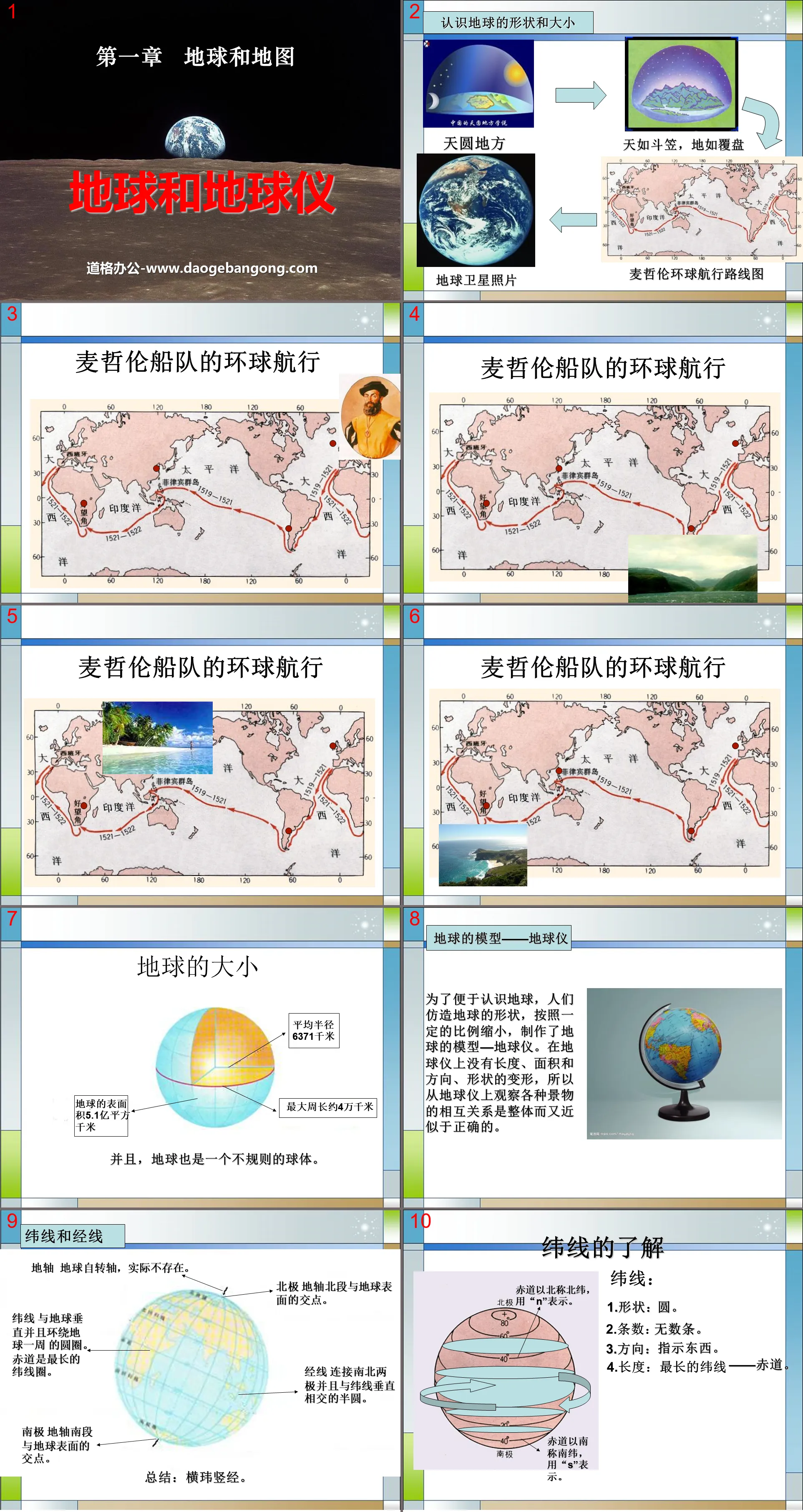
Understand the shape and size of the Earth
The sky is round and the earth is like a disk
Earth satellite photos Magellan's circumnavigation route map
size of earth
Average radius 6371 kilometers
The maximum circumference is about 40,000 kilometers
The earth’s surface area is 510 million square kilometers
Moreover, the earth is also an irregular sphere.
Model of the Earth - Globe
In order to make it easier to understand the earth, people imitated the shape of the earth and reduced it to a certain proportion to make a model of the earth - a globe. There is no deformation of length, area, direction, or shape on the globe, so observing the relationship between various scenery on the globe is holistic and approximately correct.
latitude and longitude
Earth's axis The Earth's axis of rotation, which does not actually exist.
North Pole The point where the northern portion of the Earth's axis intersects the Earth's surface.
Meridian A semicircle connecting the north and south poles and intersecting the parallels at right angles.
Lines of latitude A circle that is perpendicular to the Earth and goes around the Earth. The equator is the longest line of latitude.
Antarctica The intersection of the southern segment of the Earth's axis with the Earth's surface.
Understanding of parallels
weft:
1. Shape: circle.
2. Number of items: countless items.
3. Direction: point to something.
4. Length: The longest latitude - the equator.
Division of high, middle and low latitudes
High latitudes: 60° to 90° north and south latitudes
Mid-latitude: 30°-60° north and south latitude
Low latitude: North and South latitude 0° - 30°
understanding of longitude
warp:
1. Shape: semicircle.
2. Number of items: countless items.
3. Indicate direction: indicate north and south.
4. Length: All meridians are equal.
Jingwei.com
On a globe or map, longitude and latitude lines are intertwined to form a grid of latitude and longitude.
Using the longitude and latitude marked on it, various locations, regions and various geographical locations on the earth's surface can be determined. It is very useful in military, aviation, navigation and other aspects. For example, ships sail on the vast sea, and airplanes fly in the vast sky. No matter where they go, people can use instruments to accurately measure its longitude and latitude, thereby determining its location.
practice practice 2
Xiao Ming received a letter from an American kid named Jack. Jack made a little joke in the letter, inviting Xiao Ming to participate in summer camp activities at a longitude of 116° and a latitude of 40° during the summer vacation. Where is the location mentioned in the letter? Please look for this place on the globe and see if there are any errors.
Answer: The location of Jack cannot be determined. The Czech Republic may be at 40°N, 116°W; 40°N, 116°E; 40° S, 116°E; 40°S, 116°W.
Keywords: Earth and map teaching courseware, Earth and globe teaching courseware, People's Education Edition seventh grade geography PPT courseware download, seventh grade geography slide courseware download, Earth and map PPT courseware download, Earth and globe PPT courseware download, .PPT Format;
For more information about the "Earth and Map Earth and Globe" PPT courseware, please click the Earth and Map ppt Earth and Globe ppt tag.
"Earth and Globe" Earth and Map PPT Courseware 7:
"Earth and Globe" Earth and Map PPT Courseware 7 The Shape of the Earth Humanity's exploration of the shape of the Earth continues the process of understanding the shape of the Earth for thousands of years. In the fifth and sixth centuries BC, ancient Greek philosophers started from the concept of the perfect sphere and believed that The earth is spherical. ..
"Earth and Globe" Earth and Map PPT Courseware 6:
"Earth and Globe" Earth and Map PPT Courseware 6 1. Shape and Size of the Earth 1. Shape of the Earth Observe the picture on the right, what is the shape of the Earth? The Earth is an irregular sphere with slightly flattened poles and a slightly bulging middle. 2. Size of the Earth The average radius of the Earth..
"Earth and Globe" Earth and Map PPT Courseware 4:
"Earth and Globe" Earth and Map PPT Courseware 4 Shape characteristics of latitude lines: circle (except the two poles) Indicating direction: east-west direction Length characteristics: the equator is the longest, gradually shortening towards the north and south poles Degree range: 0~90 Degree change pattern: from the equator to the north and south poles The North and South Poles are gradually increasing...
File Info
Update Time: 2024-11-20
This template belongs to Geography courseware People's Education Edition Geography for Grade 7 Volume 1 industry PPT template
"Earth and Globe" Earth and Map PPT Courseware 5 Simple campus recruitment activity planning plan summary enterprise and institution recruitment publicity lecture PPT template is a general PPT template for business post competition provided by the manuscript PPT, simple campus recruitment activity planning plan summary enterprise and institution recruitment promotion Lecture PPT template, you can edit and modify the text and pictures in the source file by downloading the source file. If you want more exquisite business PPT templates, you can come to grid resource. Doug resource PPT, massive PPT template slide material download, we only make high-quality PPT templates!
Tips: If you open the template and feel that it is not suitable for all your needs, you can search for related content "Earth and Globe" Earth and Map PPT Courseware 5 is enough.
How to use the Windows system template
Directly decompress the file and use it with office or wps
How to use the Mac system template
Directly decompress the file and use it Office or wps can be used
Related reading
For more detailed PPT-related tutorials and font tutorials, you can view: Click to see
How to create a high-quality technological sense PPT? 4 ways to share the bottom of the box
Notice
Do not download in WeChat, Zhihu, QQ, built-in browsers, please use mobile browsers to download! If you are a mobile phone user, please download it on your computer!
1. The manuscript PPT is only for study and reference, please delete it 24 hours after downloading.
2. If the resource involves your legitimate rights and interests, delete it immediately.
3. Contact information: service@daogebangong.com
"Earth and Globe" Earth and Map PPT Courseware 5, due to usage restrictions, it is only for personal study and reference use. For commercial use, please go to the relevant official website for authorization.
(Personal non-commercial use refers to the use of this font to complete the display of personal works, including but not limited to the design of personal papers, resumes, etc.)
Preview


