Business Planet Edition 7th Grade Geography Volume 2
Business Planet Edition Geography for Grade 8 Volume 1
Business Planet Edition 7th Grade Geography Volume 1
People's Education Edition Geography for Seventh Grade Volume 2
Shanghai Education Edition Seventh Grade Geography Volume 1
Business Planet Edition Geography for Eighth Grade Volume 2
Hunan Education Edition High School Geography Compulsory Course I
People's Education Edition Geography for Grade 7 Volume 1
People's Education Edition Geography for Eighth Grade Volume 2
Lu Ke version of high school geography compulsory course I
Shanghai Education Edition Geography for Sixth Graders Volume 1
Hunan Education Edition High School Geography Compulsory Course II
Shanghai Education Edition Seventh Grade Geography Volume 2
People's Education Edition Geography for Grade 8 Volume 1
Compulsory Course 1 of High School Geography in China Graphics Edition
People's Education Press High School Geography Compulsory Course 1

| Category | Format | Size |
|---|---|---|
| People's Education Edition Geography for Grade 7 Volume 1 | pptx | 6 MB |

"Interpretation of Topographic Maps" Earth and Maps PPT Courseware 7
2024-10-01
Copyright statement: This material is compiled and released by the user of Daoge Resources. The copyright belongs to the author. For commercial use, please contact the copyright owner. If there is any infringement, please contact the webmaster to remove the resource.
Download Points: 0.00
Free Download
Upgrade VIP
Favorite
Views: 2686 / Downloads: 915
Description
"Interpretation of Topographic Maps" Earth and Maps PPT Courseware 7
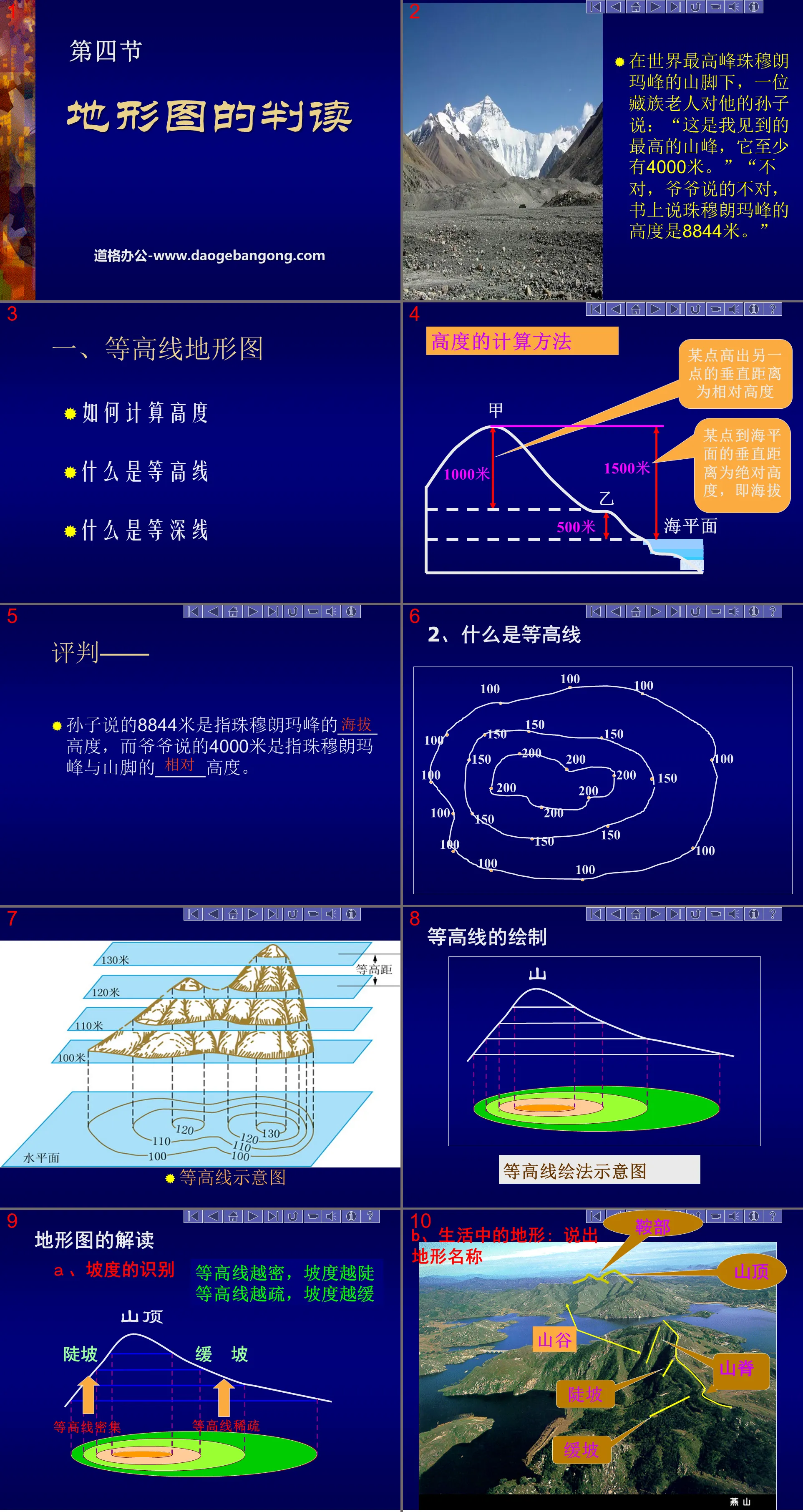
1. Contour topographic map
How to calculate height
What are contour lines
What are depth contours
How to calculate height
The vertical distance between a point and another point is the relative height
The vertical distance from a certain point to sea level is the absolute height, that is, altitude
Interpretation of topographic maps
A. Identification of slope
The denser the contours, the steeper the slope
The sparser the contours, the gentler the slope.
B. Terrain in life: Name the terrain
① Compare the drawn contour lines with the terrain model and think:
How to judge the five types of mountain topography on the contour topographic map based on the curvature and density characteristics of the contour lines
②Interpretation of topographic maps
The morphology and contour distribution of different parts of the mountain
2. Layered color topographic map
What is a layered color topographic map?
On a topographic map with contour lines and isobaths, the depth ranges at different heights are colored in different colors (the ocean is colored in different shades of blue), so that the high and low forms of the earth's surface can be clearly seen. The undulations of the seafloor are called layered color topographic maps.
Combined with Figure 1.42 on page 27 of the textbook and the reality of life, summarize the altitude characteristics and ground relief of the five land terrains:
Plateau - high altitude, generally above 1000 meters, with flat top and steep edges.
Mountainous areas - higher altitudes, generally above 500 meters, with undulating peaks and steep slopes.
Hills - lower altitude, generally between 200 and 500 meters, with undulating ground but gentle slopes.
Plain - low altitude, generally below 200 meters, with flat ground.
Basin - high on all sides, low in the middle.
Demonstration of ability
1. The altitude of Mount Everest, the highest peak in the world, is 8844 meters. The average altitude of Turpan Basin, the lowest point on land in my country, is -155 meters. Then the relative height of the two places is _______ meters.
2. Read the picture on the right and complete the following questions:
(1). The altitude range of point A in the figure is ( )
A. Greater than 260 meters B. Less than 260 meters
C. Between 240 meters and 260 meters D. Between 260 meters and 280 meters
(2) It is easier to climb from the ______ (B, C) slope in the picture to the top of the mountain A, because ___________.
(3) In the land terrain landscape, the terrain represented by this picture belongs to ( )
A. Mountains B. Hills C. Plateau D. Basin
3. Read the picture on the right and complete the following questions:
(1) The altitude of point F in the figure is ______ meters.
(2) Write the name of the terrain represented by the letters:
A________ B________
C________ D________ E_________
(3) What are the differences between climbing along ① and ② in the picture?
① The slope of the line is gentle and labor-saving; ② The slope of the line is steep and labor-saving
Keywords: Earth and map teaching courseware, topographic map interpretation teaching courseware, People's Education Edition seventh grade geography PPT courseware download, seventh grade geography slide courseware download, Earth and map PPT courseware download, topographic map interpretation PPT courseware download, .PPT format;
For more information about the "Interpretation of Topographic Maps, Earth and Maps" PPT courseware, please click on the "Interpretation of Topographic Maps ppt Earth and Maps ppt" tag.
"Interpretation of Topographic Maps" PPT download:
"Interpretation of Topographic Maps" PPT Download Part One: New Lesson Knowledge 1. Introduction of New Lessons Xiao Ming competed with TOM to climb Mount Tai. The smart TOM quickly climbed to the top of the mountain with the help of a map. Does anyone know what map it is? They faced Mount Tai from the foot of the mountain to the top...
"Interpretation of Topographic Maps" PPT courseware:
"Interpretation of Topographic Maps" PPT courseware Part 1: Learning objectives 1. What is the definition and calculation of altitude and relative altitude? 2. What is the definition of terrain? What are the five common types of terrain and their characteristics? 3. Identify the slope size and cliffs, peaks, saddles, mountains...
"Interpretation of Topographic Maps" PPT:
"Interpretation of Topographic Maps" PPT Part One Content: New Lesson Learning The vertical distance between a certain point and another point is called the relative height. The vertical distance between a certain point and the sea level is called the absolute height, which is the various ups and downs of the altitude surface. Collectively called terrain. Five kinds of ground...
File Info
Update Time: 2024-10-01
This template belongs to Geography courseware People's Education Edition Geography for Grade 7 Volume 1 industry PPT template
"Interpretation of Topographic Maps" Earth and Maps PPT Courseware 7 Simple campus recruitment activity planning plan summary enterprise and institution recruitment publicity lecture PPT template is a general PPT template for business post competition provided by the manuscript PPT, simple campus recruitment activity planning plan summary enterprise and institution recruitment promotion Lecture PPT template, you can edit and modify the text and pictures in the source file by downloading the source file. If you want more exquisite business PPT templates, you can come to grid resource. Doug resource PPT, massive PPT template slide material download, we only make high-quality PPT templates!
Tips: If you open the template and feel that it is not suitable for all your needs, you can search for related content "Interpretation of Topographic Maps" Earth and Maps PPT Courseware 7 is enough.
How to use the Windows system template
Directly decompress the file and use it with office or wps
How to use the Mac system template
Directly decompress the file and use it Office or wps can be used
Related reading
For more detailed PPT-related tutorials and font tutorials, you can view: Click to see
How to create a high-quality technological sense PPT? 4 ways to share the bottom of the box
Notice
Do not download in WeChat, Zhihu, QQ, built-in browsers, please use mobile browsers to download! If you are a mobile phone user, please download it on your computer!
1. The manuscript PPT is only for study and reference, please delete it 24 hours after downloading.
2. If the resource involves your legitimate rights and interests, delete it immediately.
3. Contact information: service@daogebangong.com
"Interpretation of Topographic Maps" Earth and Maps PPT Courseware 7, due to usage restrictions, it is only for personal study and reference use. For commercial use, please go to the relevant official website for authorization.
(Personal non-commercial use refers to the use of this font to complete the display of personal works, including but not limited to the design of personal papers, resumes, etc.)
Preview
Related Search:
"Interpretation of Topographic Maps" Earth and Maps PPT Courseware 7
2024-10-01
Copyright statement: This material is compiled and released by the user of Daoge Resources. The copyright belongs to the author. For commercial use, please contact the copyright owner. If there is any infringement, please contact the webmaster to remove the resource.
Download Points: 0.00
Free Download
Upgrade VIP
Favorite
Views: 2686 / Downloads: 915


