Business Planet Edition 7th Grade Geography Volume 1
Business Planet Edition 7th Grade Geography Volume 2
People's Education Edition Geography for Seventh Grade Volume 2
Business Planet Edition Geography for Grade 8 Volume 1
People's Education Edition Geography for Eighth Grade Volume 2
Hunan Education Edition High School Geography Compulsory Course I
Shanghai Education Edition Seventh Grade Geography Volume 1
People's Education Edition Geography for Grade 8 Volume 1
Compulsory Course 1 of High School Geography in China Graphics Edition
People's Education Edition Geography for Grade 7 Volume 1
Shanghai Education Edition Geography for Sixth Graders Volume 1
Lu Ke version of high school geography compulsory course I
People's Education Press High School Geography Compulsory Course 1
Hunan Education Edition High School Geography Compulsory Course II
Shanghai Education Edition Seventh Grade Geography Volume 2
Business Planet Edition Geography for Eighth Grade Volume 2

| Category | Format | Size |
|---|---|---|
| People's Education Edition Geography for Grade 7 Volume 1 | pptx | 6 MB |

"Interpretation of Topographic Maps" Earth and Maps PPT Courseware 4
2024-11-22
Copyright statement: This material is compiled and released by the user of Daoge Resources. The copyright belongs to the author. For commercial use, please contact the copyright owner. If there is any infringement, please contact the webmaster to remove the resource.
Download Points: 0.00
Free Download
Upgrade VIP
Favorite
Views: 4663 / Downloads: 413
Description
"Interpretation of Topographic Maps" Earth and Maps PPT Courseware 4
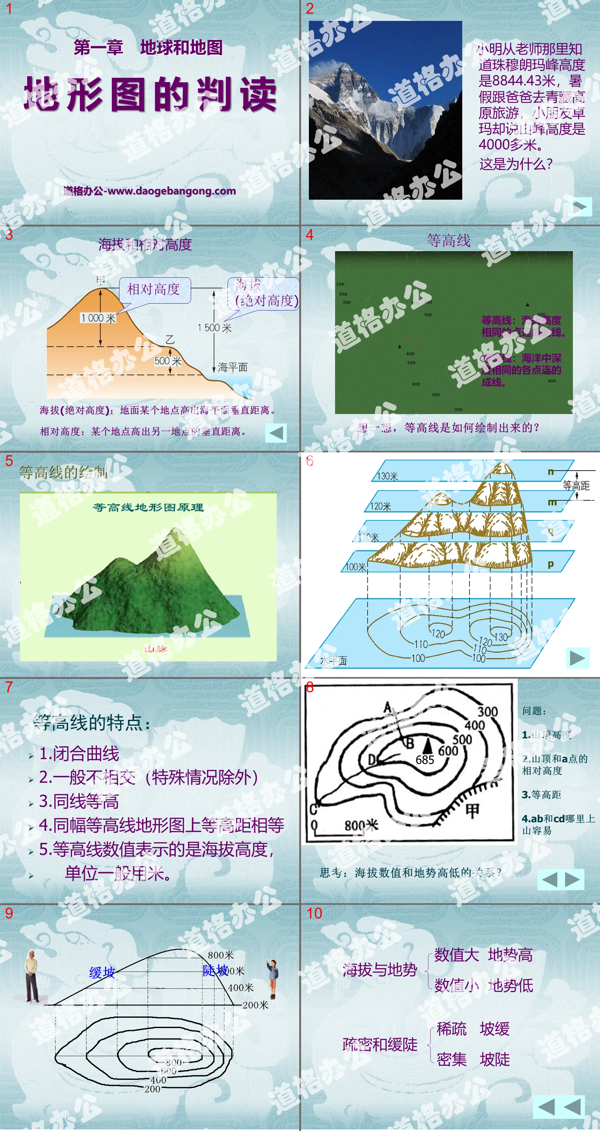
Xiao Ming learned from his teacher that the height of Mount Everest is 8,844.43 meters. He went to the Qinghai-Tibet Plateau with his father during the summer vacation, but his child Dolma said that the height of the mountain was more than 4,000 meters.
why is that?
Altitude and relative altitude
Altitude (absolute height): The vertical distance above sea level at a location on the ground.
Relative height: The vertical distance that one location is above another location.
contour line
Contour line: A line connecting points with the same altitude.
Isobath: A line connecting points of the same depth in the ocean.
Think about it, how are contour lines drawn?
Features of contour lines:
1. Closed curve
2. Generally disjoint (except in special circumstances)
3. Same line and same height
4. Contour distances on the same contour topographic map are equal
5. The contour value represents the altitude, and the unit is generally meters.
The contour line is a closed curve, with values gradually decreasing from the center to the surrounding areas.
The contour line is a closed curve, with values gradually increasing from the center to the surrounding areas.
3. Layered color topographic map
Blue represents the ocean
Green represents plains
Yellow represents plateau,
hills and mountains
Brown represents mountains
White represents above the snow line
Keywords: Earth and map teaching courseware, topographic map interpretation teaching courseware, People's Education Edition seventh grade geography PPT courseware download, seventh grade geography slide courseware download, Earth and map PPT courseware download, topographic map interpretation PPT courseware download, .PPT format;
For more information about the "Interpretation of Topographic Maps Earth and Maps" PPT courseware, please click on the Interpretation of Topographic Maps PPT Earth and Maps PPT tag.
"Interpretation of Topographic Maps" PPT download:
"Interpretation of Topographic Maps" PPT Download Part One: New Lesson Knowledge 1. Introduction of New Lessons Xiao Ming competed with TOM to climb Mount Tai. The smart TOM quickly climbed to the top of the mountain with the help of a map. Does anyone know what map it is? They faced Mount Tai from the foot of the mountain to the top...
"Interpretation of Topographic Maps" PPT courseware:
"Interpretation of Topographic Maps" PPT courseware Part 1: Learning objectives 1. What is the definition and calculation of altitude and relative altitude? 2. What is the definition of terrain? What are the five common types of terrain and their characteristics? 3. Identify the slope size and cliffs, peaks, saddles, mountains...
"Interpretation of Topographic Maps" PPT:
"Interpretation of Topographic Maps" PPT Part One Content: New Lesson Learning The vertical distance between a certain point and another point is called the relative height. The vertical distance between a certain point and the sea level is called the absolute height, which is the various ups and downs of the altitude surface. Collectively called terrain. Five kinds of ground...
File Info
Update Time: 2024-11-22
This template belongs to Geography courseware People's Education Edition Geography for Grade 7 Volume 1 industry PPT template
"Interpretation of Topographic Maps" Earth and Maps PPT Courseware 4 Simple campus recruitment activity planning plan summary enterprise and institution recruitment publicity lecture PPT template is a general PPT template for business post competition provided by the manuscript PPT, simple campus recruitment activity planning plan summary enterprise and institution recruitment promotion Lecture PPT template, you can edit and modify the text and pictures in the source file by downloading the source file. If you want more exquisite business PPT templates, you can come to grid resource. Doug resource PPT, massive PPT template slide material download, we only make high-quality PPT templates!
Tips: If you open the template and feel that it is not suitable for all your needs, you can search for related content "Interpretation of Topographic Maps" Earth and Maps PPT Courseware 4 is enough.
How to use the Windows system template
Directly decompress the file and use it with office or wps
How to use the Mac system template
Directly decompress the file and use it Office or wps can be used
Related reading
For more detailed PPT-related tutorials and font tutorials, you can view: Click to see
How to create a high-quality technological sense PPT? 4 ways to share the bottom of the box
Notice
Do not download in WeChat, Zhihu, QQ, built-in browsers, please use mobile browsers to download! If you are a mobile phone user, please download it on your computer!
1. The manuscript PPT is only for study and reference, please delete it 24 hours after downloading.
2. If the resource involves your legitimate rights and interests, delete it immediately.
3. Contact information: service@daogebangong.com
"Interpretation of Topographic Maps" Earth and Maps PPT Courseware 4, due to usage restrictions, it is only for personal study and reference use. For commercial use, please go to the relevant official website for authorization.
(Personal non-commercial use refers to the use of this font to complete the display of personal works, including but not limited to the design of personal papers, resumes, etc.)
Preview
Related Search:
"Interpretation of Topographic Maps" Earth and Maps PPT Courseware 4
2024-11-22
Copyright statement: This material is compiled and released by the user of Daoge Resources. The copyright belongs to the author. For commercial use, please contact the copyright owner. If there is any infringement, please contact the webmaster to remove the resource.
Download Points: 0.00
Free Download
Upgrade VIP
Favorite
Views: 4663 / Downloads: 413


