Business Planet Edition 7th Grade Geography Volume 2
Business Planet Edition Geography for Grade 8 Volume 1
Business Planet Edition 7th Grade Geography Volume 1
People's Education Edition Geography for Seventh Grade Volume 2
Shanghai Education Edition Seventh Grade Geography Volume 1
Business Planet Edition Geography for Eighth Grade Volume 2
Hunan Education Edition High School Geography Compulsory Course I
People's Education Edition Geography for Grade 7 Volume 1
People's Education Edition Geography for Eighth Grade Volume 2
Shanghai Education Edition Geography for Sixth Graders Volume 1
Lu Ke version of high school geography compulsory course I
Hunan Education Edition High School Geography Compulsory Course II
Shanghai Education Edition Seventh Grade Geography Volume 2
Compulsory Course 1 of High School Geography in China Graphics Edition
People's Education Edition Geography for Grade 8 Volume 1
People's Education Press High School Geography Compulsory Course 1
| Category | Format | Size |
|---|---|---|
| Compulsory Course 1 of High School Geography in China Graphics Edition | pptx | 6 MB |

"Application of Geographic Information Technology" Basic Methods of Physical Geography Practice PPT
2024-10-03
Copyright statement: This material is compiled and released by the user of Daoge Resources. The copyright belongs to the author. For commercial use, please contact the copyright owner. If there is any infringement, please contact the webmaster to remove the resource.
Download Points: 0.00
Free Download
Upgrade VIP
Favorite
Views: 3431 / Downloads: 770
Description
"Application of Geographic Information Technology" Basic Methods of Physical Geography Practice PPT
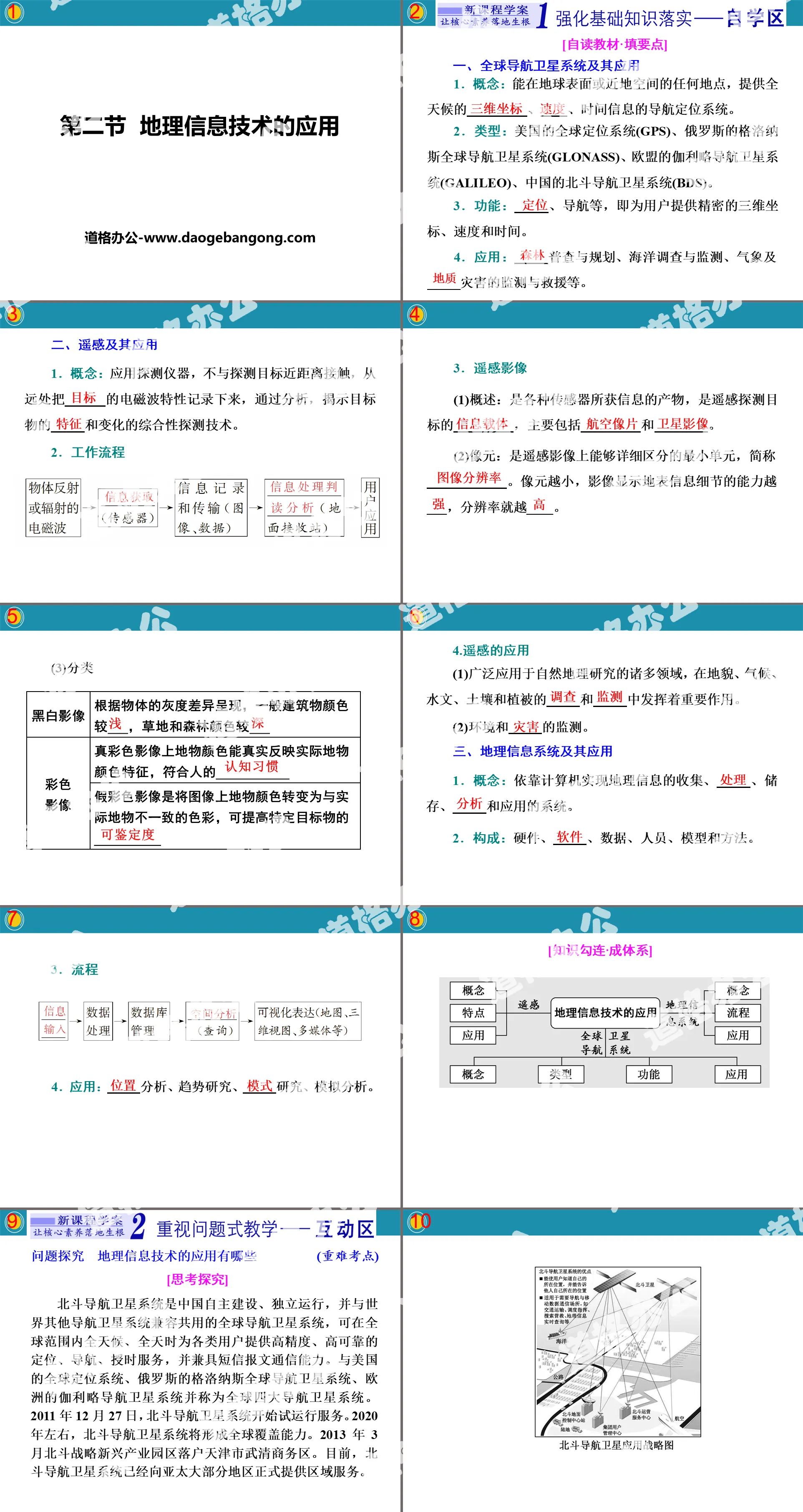
Part One: Strengthening the Implementation of Basic Knowledge
[Self-reading textbook·Fill in key points]
1. Global navigation satellite systems and their applications
1. Concept: A navigation and positioning system that can provide all-weather ______, ______, and time information at any location on the earth's surface or near-Earth space.
2. Type: US Global Positioning System (GPS), Russia's GLONASS Global Navigation Satellite System (GLONASS), EU's Galileo Navigation Satellite System (GALILEO), China's Beidou Navigation Satellite System (BDS).
3. Functions: ______, navigation, etc., which provide users with precise three-dimensional coordinates, speed and time.
4. Application: ______ census and planning, marine survey and monitoring, meteorological and _____ disaster monitoring and rescue, etc.
2. Remote sensing and its applications
1. Concept: A comprehensive detection technology that uses detection instruments to record the electromagnetic wave characteristics of ______ from a distance without close contact with the detection target, and through analysis, reveals the ______ and changes of the target object.
2. work process
3. remote sensing images
(1) Overview: It is the product of information obtained by various sensors and is the ______ of remote sensing detection targets, mainly including ______ and ______.
(2) Pixel: It is the smallest unit that can be distinguished in detail on remote sensing images, referred to as ______. The smaller the pixel, the more ___ the ability of the image to display surface information details, and the ____ the resolution.
(3)Classification
black and white image
According to the grayscale differences of objects, the colors of buildings are generally ___, and the colors of grass and forests are ___.
color image
The colors of ground objects on true color images can truly reflect the color characteristics of actual ground objects and conform to human ___________
False color images convert the colors of the objects on the image into colors that are inconsistent with the actual objects, which can improve the __________ of specific objects.
4. Applications of remote sensing
(1) It is widely used in many fields of physical geography research and plays an important role in the ______ and ______ of landforms, climate, hydrology, soil and vegetation.
(2) Monitoring of environment and environment.
3. Geographic information system and its applications
1. Concept: A system that relies on computers to collect, ______, store, ______ and apply geographic information.
2. Composition: Hardware, ______, data, people, models, and methods.
3. process
4. Application: ______ analysis, trend research, ______ research, simulation analysis.
PPT on the application of geographical information technology, part 2: attaching importance to problem-based teaching
Question exploration: What are the applications of geographic information technology? Important and difficult test points
[Thinking and exploring]
The Beidou Navigation Satellite System is a global navigation satellite system independently constructed and operated by China, and is compatible and shared with other navigation satellite systems in the world. It can provide high-precision and highly reliable positioning for all types of users around the world, all day and night. Navigation, timing services, and SMS messaging capabilities. Together with the United States' Global Positioning System, Russia's GLONASS global navigation satellite system, and Europe's Galileo navigation satellite system, it is known as the world's four major navigation satellite systems. On December 27, 2011, the Beidou navigation satellite system began trial operation services. Around 2020, the Beidou navigation satellite system will form global coverage capabilities. In March 2013, the Beidou Strategic Emerging Industrial Park was settled in Wuqing Business District, Tianjin. At present, the Beidou navigation satellite system has officially provided regional services to most regions in the Asia-Pacific.
[Problem Design]
1. Use "comprehensive thinking" to analyze what parts the Beidou navigation satellite system consists of? What are its main features?
Tip: It consists of three parts: navigation and communication satellites, ground control center and mobile terminal. It is global, all-weather, continuous and real-time.
2. Use "comprehensive thinking" to analyze what are the main functions of the Beidou navigation satellite system? What other geographic information technologies are there?
Tips: Positioning and navigation. Remote sensing, geographic information systems.
3. From the perspective of "geographical practicality", in what other fields do you think the Beidou navigation satellite system is widely used?
Tips: Forest census and regulations, marine survey and monitoring, monitoring and rescue of meteorological and geological disasters, etc.
[System Cognition]
1. Global Navigation Satellite System Applications
2. Application of remote sensing
(1) Resource census, environment and disaster monitoring
(2)Agricultural aspects
3. Applications of Geographic Information Systems
(1) Four basic problems solved by geographic information systems
(2) Application of geographic information system in real life
①Application in regional geographical environment research
②Application in urban management
[Training to pass the test]
With the development of science and technology, my country's typhoon forecasting technical capabilities have greatly improved, and the accuracy of typhoon forecasting has steadily improved year by year. The picture below is a satellite cloud image of a certain typhoon. Answer questions 1-2 accordingly.
1. The satellite cloud images sent back by meteorological satellites mainly use ()
A. Global Navigation Satellite System B. remote sensing
C. Geographic information system D. virtual technology
2. At present, meteorological satellites are mainly used to monitor typhoons. By analyzing multiple satellite cloud pictures, it can be obtained ()
①The location of the center of the typhoon; ②The intensity and speed of the typhoon; ③The intensity of precipitation caused by the typhoon; ④The moving direction of the typhoon; ⑤The landing area of the typhoon
A. ①②③⑤ B. ②③④⑤
C. ①③④⑤D. ①②④⑤
Analysis: Remote sensing can obtain satellite cloud images. Weather conditions in any place can be seen from meteorological satellite cloud images, and the location, intensity, moving direction and speed of typhoons can be monitored. This provides a basis for real-time weather forecasting, but it cannot obtain information on the intensity of precipitation caused by typhoons.
The map heat map is based on the geographical location data of mobile phone users and describes the distribution of urban crowds in real time through different color blocks superimposed on the online map. The picture below shows the (partial) map heat map of Shanghai at 9 a.m. on a certain day. Complete questions 3-4.
3. The geographical information technology used in this map is mainly ()
A. GNSS and GIS B. RS and GIS
C. RS and GNSS D. GNSS and IT
4. The thermal high value area in the figure is most likely ()
A. Industrial area b. Residential area
C. Business district D. administrative district
5. Overlaying C and D layers can be studied ()
A. River distributionB. terrain features
C. Store distribution D. Passenger and cargo traffic
PPT on the application of geographical information technology, part three: carrying out structural evaluation of thinking
Structural evaluation of thinking - application of geographical information technology in typhoon disaster prevention and reduction
Typhoon No. 22 of 2018 "Mangkhut" was generated in the northwest Pacific Ocean at 20:00 on September 7, 2018, and rapidly intensified in the warm northwest Pacific Ocean. On September 15, "Mangkhut" made landfall on Luzon Island in the Philippines as a super typhoon, and its majesty continued unabated. At around 17:00 on September 16, it made landfall on the coast of Taishan, Jiangmen City, Guangdong, my country, with a strong typhoon level near the center when it landed. The maximum wind force was level 14 and the minimum pressure was 955 hPa. It was the strongest typhoon to land in my country in 2018. From the 16th to the 18th, the wind force in the central and western coastal areas of South China was 14-16, with gusts reaching 17 or above; heavy rainstorms occurred in parts of southern Guangdong, Hong Kong, Macau, southern Guangxi, Hainan Island, southern Yunnan and other places, and extremely heavy rainstorms occurred locally. Please discuss how to use geographic information technology to effectively prevent or mitigate typhoon disasters?
Keywords: Free download of PPT courseware for high school geography compulsory course I of China Graphics Edition, PPT download of application of geographic information technology, PPT download of basic methods of physical geography practice, .PPT format;
For more information about the PPT courseware "Basic Methods of Physical Geography Practice and Application of Geographic Information Technology", please click the Basic Methods of Physical Geography Practice ppt Application of Geographic Information Technology ppt tag.
"Application of Geographic Information Technology" Basic methods of physical geography practice PPT courseware:
"Application of Geographic Information Technology" PPT courseware on basic methods of physical geography practice Part 1: Basic review 1. Global navigation satellite systems and their applications 1. Concept: Able to provide all-weather __________...
"Physical Geography Field Practice Methods" Basic methods of physical geography practice PPT courseware:
"Physical Geography Field Practice Methods" Basic Methods of Physical Geography Practice PPT Courseware Part One: Strengthening the Implementation of Basic Knowledge [Key Points for Filling in Self-Reading Textbooks] 1. Preparation for Field Practice 1. Data preparation (1) Purpose ① Understand the basic information of ______ of the place..
"Physical Geography Field Practice Methods" Basic methods of physical geography practice PPT:
"Physical Geography Field Practice Methods" Basic methods of physical geography practice PPT Part 1: Basic review 1. Preparation for field practice 1. Data preparation (1) Collect or review geology, geomorphology, climate, hydrology, soil related to the internship area or location..
File Info
Update Time: 2024-10-03
This template belongs to Geography courseware Compulsory Course 1 of High School Geography in China Graphics Edition industry PPT template
"Application of Geographic Information Technology" Basic Methods of Physical Geography Practice PPT Simple campus recruitment activity planning plan summary enterprise and institution recruitment publicity lecture PPT template is a general PPT template for business post competition provided by the manuscript PPT, simple campus recruitment activity planning plan summary enterprise and institution recruitment promotion Lecture PPT template, you can edit and modify the text and pictures in the source file by downloading the source file. If you want more exquisite business PPT templates, you can come to grid resource. Doug resource PPT, massive PPT template slide material download, we only make high-quality PPT templates!
Tips: If you open the template and feel that it is not suitable for all your needs, you can search for related content "Application of Geographic Information Technology" Basic Methods of Physical Geography Practice PPT is enough.
How to use the Windows system template
Directly decompress the file and use it with office or wps
How to use the Mac system template
Directly decompress the file and use it Office or wps can be used
Related reading
For more detailed PPT-related tutorials and font tutorials, you can view: Click to see
How to create a high-quality technological sense PPT? 4 ways to share the bottom of the box
Notice
Do not download in WeChat, Zhihu, QQ, built-in browsers, please use mobile browsers to download! If you are a mobile phone user, please download it on your computer!
1. The manuscript PPT is only for study and reference, please delete it 24 hours after downloading.
2. If the resource involves your legitimate rights and interests, delete it immediately.
3. Contact information: service@daogebangong.com
"Application of Geographic Information Technology" Basic Methods of Physical Geography Practice PPT, due to usage restrictions, it is only for personal study and reference use. For commercial use, please go to the relevant official website for authorization.
(Personal non-commercial use refers to the use of this font to complete the display of personal works, including but not limited to the design of personal papers, resumes, etc.)
Preview
Related Search:
"Application of Geographic Information Technology" Basic Methods of Physical Geography Practice PPT
2024-10-03
Copyright statement: This material is compiled and released by the user of Daoge Resources. The copyright belongs to the author. For commercial use, please contact the copyright owner. If there is any infringement, please contact the webmaster to remove the resource.
Download Points: 0.00
Free Download
Upgrade VIP
Favorite
Views: 3431 / Downloads: 770


