Fifth Grade Science Volume 1, Textbook Edition
Science Edition for Sixth Grade Science Volume 2
Third Grade Science Volume 2, Textbook Edition
Science Edition for Sixth Grade Science Volume 1
Third Grade Science Volume 1, Textbook Edition
Fourth Grade Science Volume 2, Textbook Edition
Fourth Grade Science Volume 1, Textbook Edition
Qingdao Edition Fourth Grade Science Volume 2
Fourth-grade science volume 2 of the E-education edition
Hunan Education Edition Fourth Grade Science Volume 1
E-education edition fifth grade science volume 2
Fifth Grade Science Volume 2, Textbook Edition
E-education edition fifth grade science volume 1
Qingdao Edition Fifth Grade Science Volume 2
E-education edition sixth grade science volume 1
Zhejiang Education Edition Seventh Grade Science Volume 2

| Category | Format | Size |
|---|---|---|
| Zhejiang Education Edition Seventh Grade Science Volume 1 | pptx | 6 MB |

"Topography and Topographic Maps" PPT
2024-09-27
Copyright statement: This material is compiled and released by the user of Daoge Resources. The copyright belongs to the author. For commercial use, please contact the copyright owner. If there is any infringement, please contact the webmaster to remove the resource.
Download Points: 0.00
Free Download
Upgrade VIP
Favorite
Views: 4710 / Downloads: 528
Description
"Topography and Topographic Maps" PPT
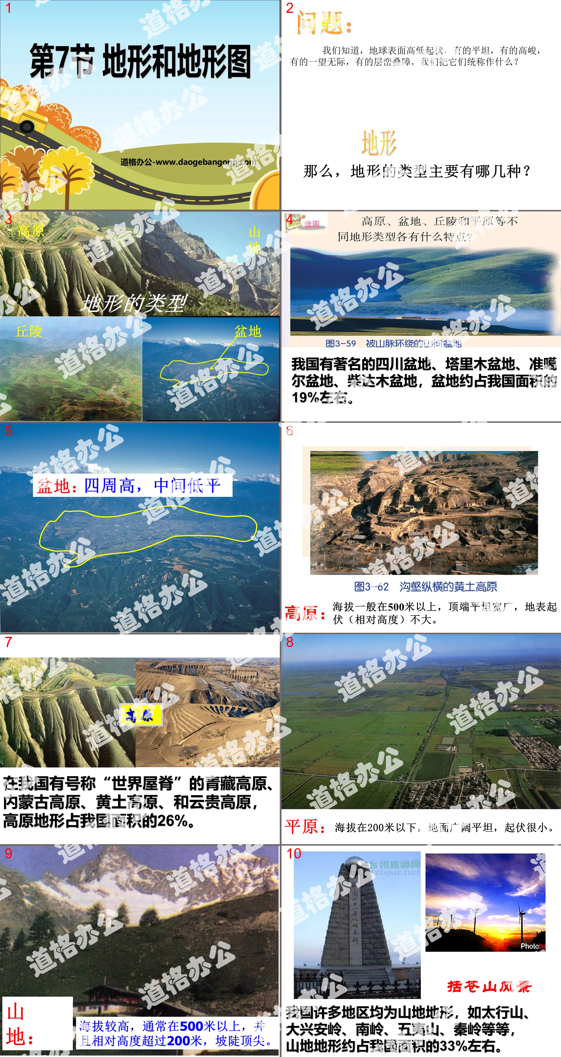
Part One: Questions:
We know that the surface of the earth is ups and downs, some are flat, some are high, some are endless, and some are stacked. What do we call them collectively?
terrain
So, what are the main types of terrain?
Basin: high on all sides, low and flat in the middle
Plateau: The altitude is generally above 500 meters, the top is flat and broad, and the surface undulations (relative height) are not large.
Plain: The altitude is below 200 meters, the ground is broad and flat, with small fluctuations.
Mountainous areas: higher altitudes, usually above 500 meters, with relative heights exceeding 200 meters, and steep slopes.
Hills: The altitude is generally 200-500 meters, the ground undulations and slopes are gentle, and the relative height is generally below 100 meters.
Terrain and topographic map PPT, Part 2: Five types of terrain
think:
1. What is altitude?
The vertical distance of a point on the ground above sea level
2. What is relative height?
The vertical distance between one location on the ground and another, that is, the height difference between the two locations.
What are the main terrain types in your hometown? What impact do such terrain features have on local economic development?
Topography and topographic maps PPT, part 3: Maps representing terrain relief
1. Contour lines:
Points with the same altitude in different undulating parts of the mountain are connected by lines. Such lines are called contour lines.
2. Characteristics of contour lines:
⑴ Wait until the altitude lines are all closed curves, and the altitude of each point on each contour line is equal.
⑵ Contour lines are dense and the slope is steep; contour lines are sparse and the slope is gentle.
Terrain and topographic map PPT, part 4: changes in terrain
The huge energy from the earth's interior formed the majestic Himalayas, and there is a deep carving in its eastern section, which is the world's largest canyon - the Brahmaputra Grand Canyon. Do you know how it was formed?
Himalayas------ formed by the collision of major plates
Yarlung Zangbo Grand Canyon-----The uplift of the Qinghai-Tibet Plateau and the erosion of the Yarlung Zangbo River
1. Internal forces: plate movement, volcanoes, earthquakes, etc.
2. External forces: wind, flowing water, glaciers, waves, organisms, etc.
The erosion of flowing water makes the Loess Plateau become criss-crossed with ravines, causing limestone to dissolve and form caves. At the same time, the sediment carried by it is deposited in the middle and lower reaches of rivers and estuaries to form plains and deltas.
The blowing of the wind will form a wind erosion castle
The deposition of sand creates deserts
The movement of glaciers creates horns and cirque valleys
Topography and topographic map PPT, part 5: Intelligence Express
1: The place where the contour line protrudes from low to high is ( )
A: saddle B: cliff C: ridge D: valley
2: The reason why caves are formed in limestone areas is ( )
A: The effect of fire B: The effect of running water
C: The effect of wind D: Earthquake
3: Among the following functions, the one that belongs to internal force is ( )
A:wind B:flowing water C:volcano D:glacier
4. What the contour topographic map represents ( )
A. Terrain at the same altitude B. Height of peaks in mountains
C. The ups and downs of the terrain D. The changes in the terrain
5. The bottom of a certain basin is 900m lower than the peak with an altitude of 768m, then the relative height between the two is ( )
A. -132m B. 1668m C. 132m D. 900m
Keywords: Zhejiang Education Edition seventh grade science PPT courseware free download, terrain and topographic map PPT download, .PPT format;
For more information about the "Topography and Topographic Maps" PPT courseware, please click on the Topographic and Topographic Maps PPT tab.
"Topography and Topographic Maps" PPT courseware:
Contents of the first part of the PPT courseware "Topography and Topographic Maps": Review 1. The terrain above 500 meters above sea level, with relatively large heights, steep slopes, towering peaks and deep valleys is ( ) A: Plains B: Plateau C: Mountains D: Basin 2. Contour lines protrude from low to high..
File Info
Update Time: 2024-09-27
This template belongs to science courseware Zhejiang Education Edition Seventh Grade Science Volume 1 industry PPT template
"Topography and Topographic Maps" PPT Simple campus recruitment activity planning plan summary enterprise and institution recruitment publicity lecture PPT template is a general PPT template for business post competition provided by the manuscript PPT, simple campus recruitment activity planning plan summary enterprise and institution recruitment promotion Lecture PPT template, you can edit and modify the text and pictures in the source file by downloading the source file. If you want more exquisite business PPT templates, you can come to grid resource. Doug resource PPT, massive PPT template slide material download, we only make high-quality PPT templates!
Tips: If you open the template and feel that it is not suitable for all your needs, you can search for related content "Topography and Topographic Maps" PPT is enough.
How to use the Windows system template
Directly decompress the file and use it with office or wps
How to use the Mac system template
Directly decompress the file and use it Office or wps can be used
Related reading
For more detailed PPT-related tutorials and font tutorials, you can view: Click to see
How to create a high-quality technological sense PPT? 4 ways to share the bottom of the box
Notice
Do not download in WeChat, Zhihu, QQ, built-in browsers, please use mobile browsers to download! If you are a mobile phone user, please download it on your computer!
1. The manuscript PPT is only for study and reference, please delete it 24 hours after downloading.
2. If the resource involves your legitimate rights and interests, delete it immediately.
3. Contact information: service@daogebangong.com
"Topography and Topographic Maps" PPT, due to usage restrictions, it is only for personal study and reference use. For commercial use, please go to the relevant official website for authorization.
(Personal non-commercial use refers to the use of this font to complete the display of personal works, including but not limited to the design of personal papers, resumes, etc.)
Preview
Related Search:
"Topography and Topographic Maps" PPT
2024-09-27
Copyright statement: This material is compiled and released by the user of Daoge Resources. The copyright belongs to the author. For commercial use, please contact the copyright owner. If there is any infringement, please contact the webmaster to remove the resource.
Download Points: 0.00
Free Download
Upgrade VIP
Favorite
Views: 4710 / Downloads: 528


