Recently I collected an ancient atlas of Asia, but I haven't seen the cover page, so I don't know when it was published or who authored it. I later looked up information online and finally discovered the source of the map. The name of the map is "Map of the Situation of Asia in China's Past Dynasties", and it is the Chinese version drawn by the British. The font of this map is traditional Chinese, written from right to left, and it should have been published during the Republic of China. This may be the earliest historical map of Asia. Let's see how this map goes.
The first is a map of Asia during the Zhou Dynasty. Although the dynasty is marked as the Zhou Dynasty, the time on the map does not match the history of the East and the West. The Chinese part is a map of the situation in the late Spring and Autumn Period, including Jin, Chu, Qi, Qin, Wu, Yue and other major countries in the Spring and Autumn Period. The part of Western Asia is marked by the Alexander Empire. At that time, the Persian Empire was powerful, and Alexander's Eastern Expedition was in 330 BC, which belonged to the middle period of the Warring States Period. Therefore, something is seriously wrong with this map.
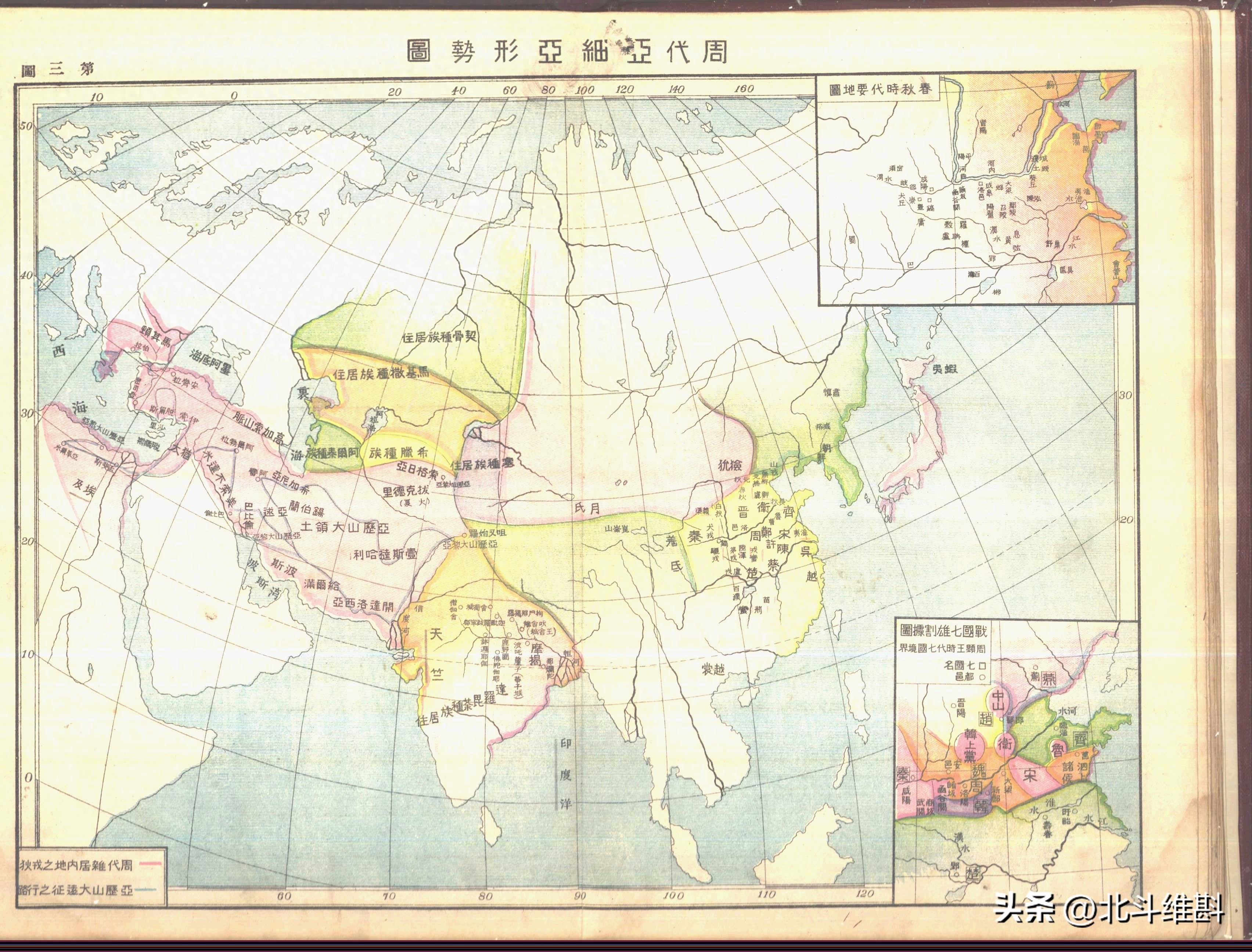
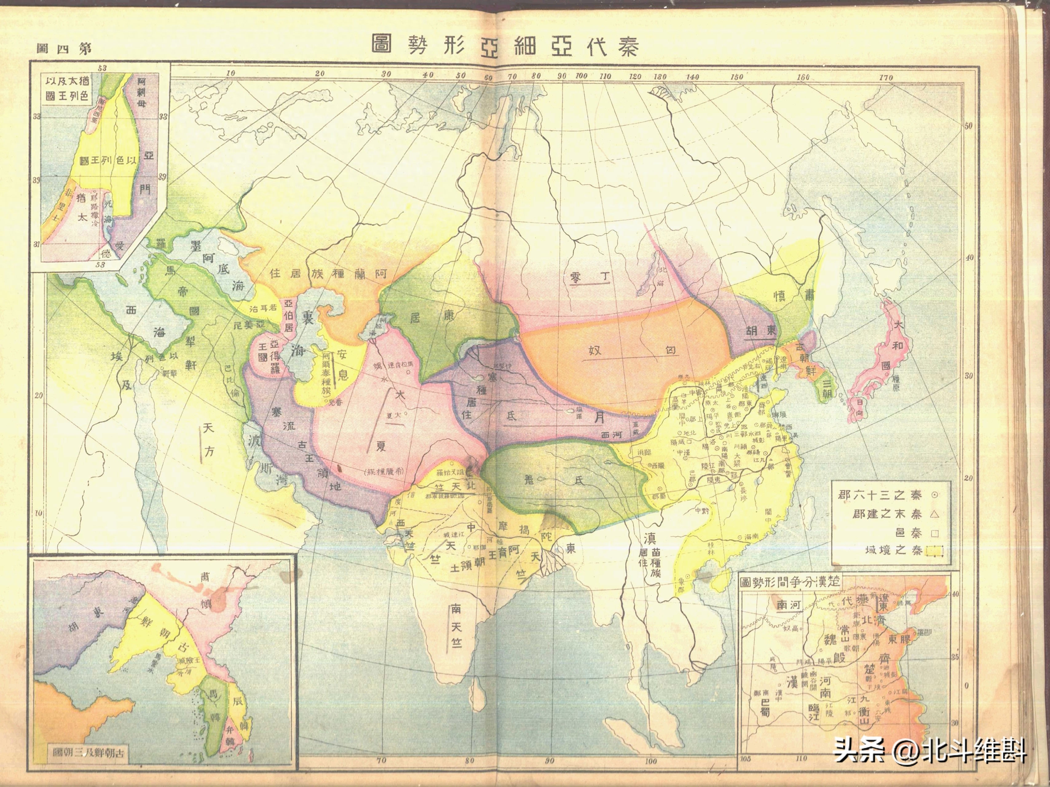
The second is a map of Asia during the Qin Dynasty. This map also has the problem of mismatch between east and west. During the Qin Dynasty, the Seleucid dynasty ruled Western Asia. It was the largest dynasty under the division of the Macedonian Empire, but the Roman Empire was shown on the map. Rome only launched war against the Hellenistic countries in 215 BC, and finally turned the Mediterranean into an inland sea in 191 BC. Therefore, serious mistakes were made here. In addition, Rome at that time was still the Roman Republic, not the Roman Empire.
The empire that existed at the same time as the Qin Dynasty and Seleucid was the Maurya Dynasty, located in the Indian subcontinent. This is correct. The location of Japan is marked by Yamato. The Yamato dynasty was only established in the 5th century and therefore could not have appeared in this era.
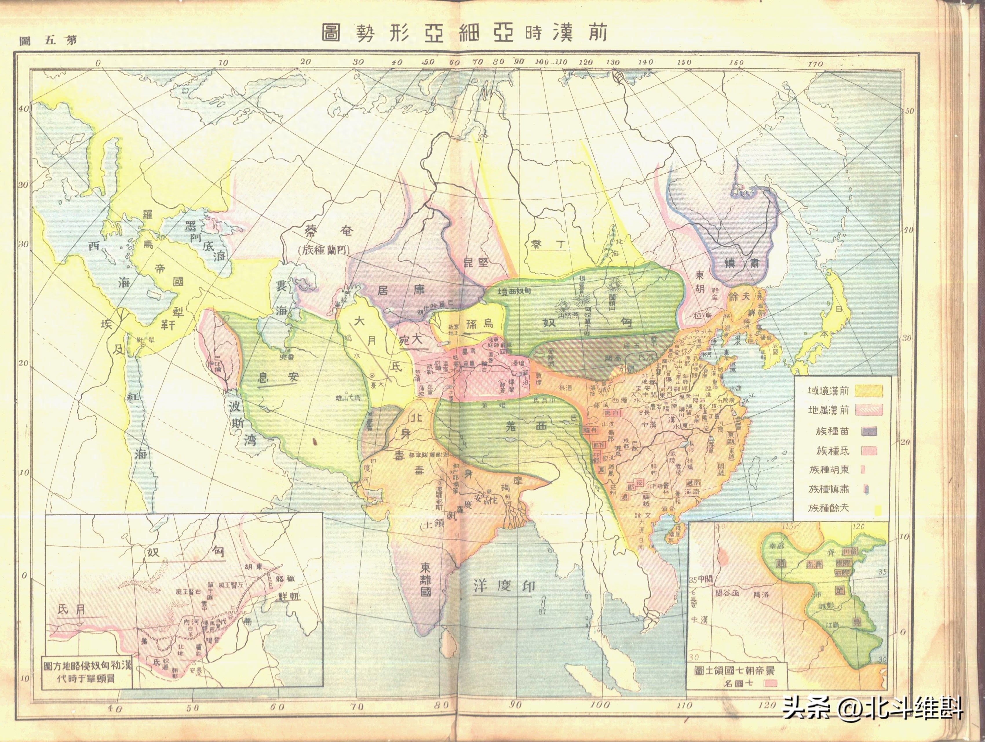
The third map is a map of Asia from the Western Han Dynasty. There are no big mistakes on this map, but there are small mistakes. For example, the Roman Empire should be labeled the Roman Republic. It should be noted that there are two places in the diagonal part of the picture, namely the Southern Xiongnu and the Western Regions, indicating that they were later controlled by the Western Han Dynasty. Between the Western Han Dynasty and Rome, there was another big country called the Parthian Empire, which is Parthia marked on the map. It was a dynasty of the Persian Empire. This dynasty prospered through pass-through trade between the Han Empire and Rome.
The fourth is a map of Asia during the Eastern Han Dynasty. This map has no obvious errors. Judging from the coexistence of the Southern and Northern Xiongnu, this should be the territory of the early Eastern Han Dynasty. However, the Han Dynasty had not yet resumed control of the Western Regions, but it controlled the Southern Xiongnu. At that time, there was another country that was gradually rising, that is, the Kushan Empire spanning Central Asia, West Asia and South Asia. It was a country established by the Yuezhi people. At that time, India was already divided.

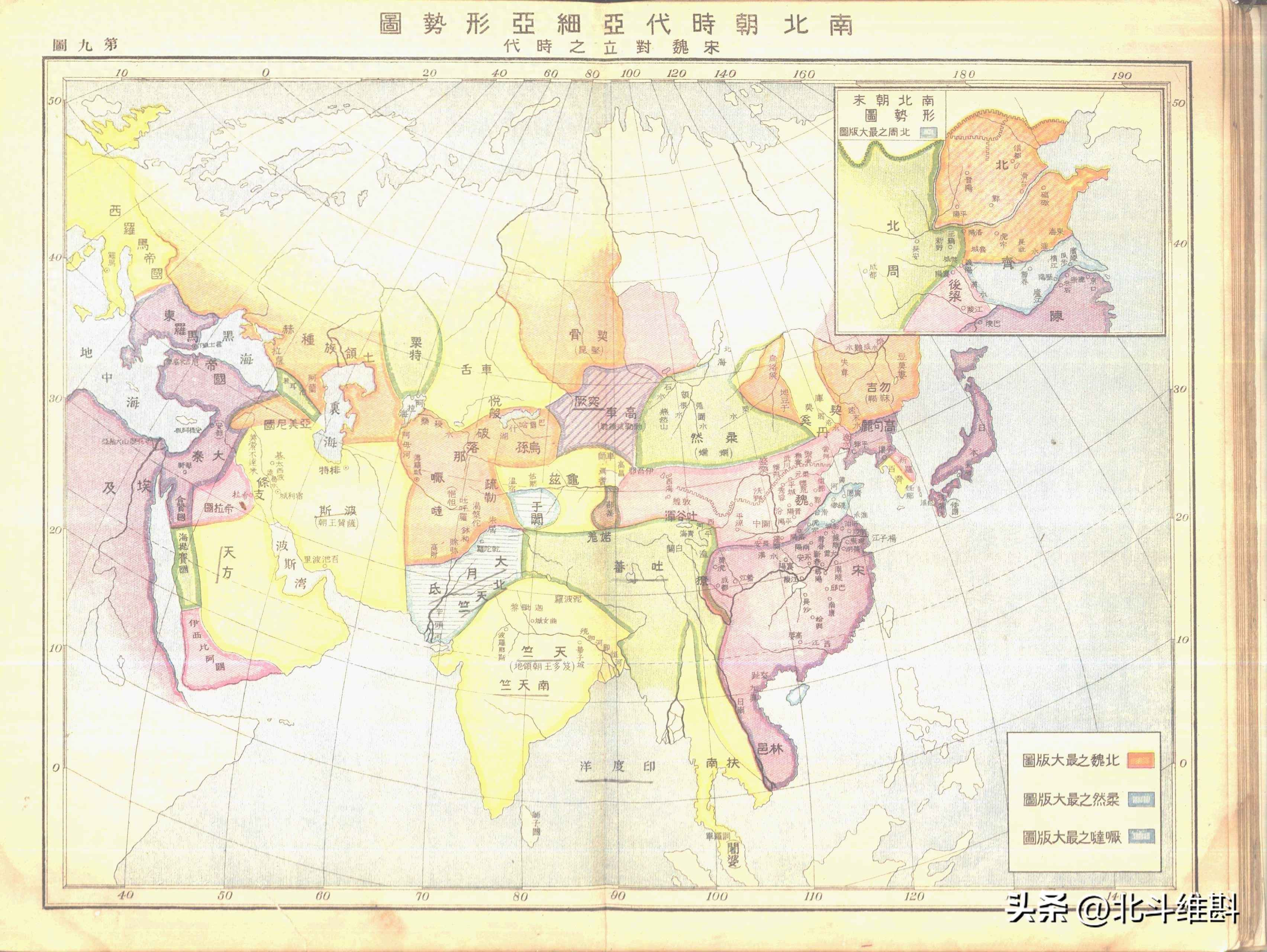
The fifth map is a map of Asia during the Three Kingdoms era. The westernmost part of the Wei Kingdom in the map is drawn to Yumen Pass, which is the drawing method of the traditional Wei State map, while the drawing method of the Wei State to the Western Regions is Tan Qixiang's drawing method. In fact, both painting methods have flaws. The Wei State did not control most of the Western Regions, but it set up farming organizations in the eastern parts of the Western Regions, proving that some areas of the Western Regions belonged to the Wei State. At that time, the Persian Sassanid Dynasty replaced the Parthian Dynasty, which was the revival era of the Persian Empire. On the grassland, the Xianbei were strong. They expelled the Huns and forced them to move south.
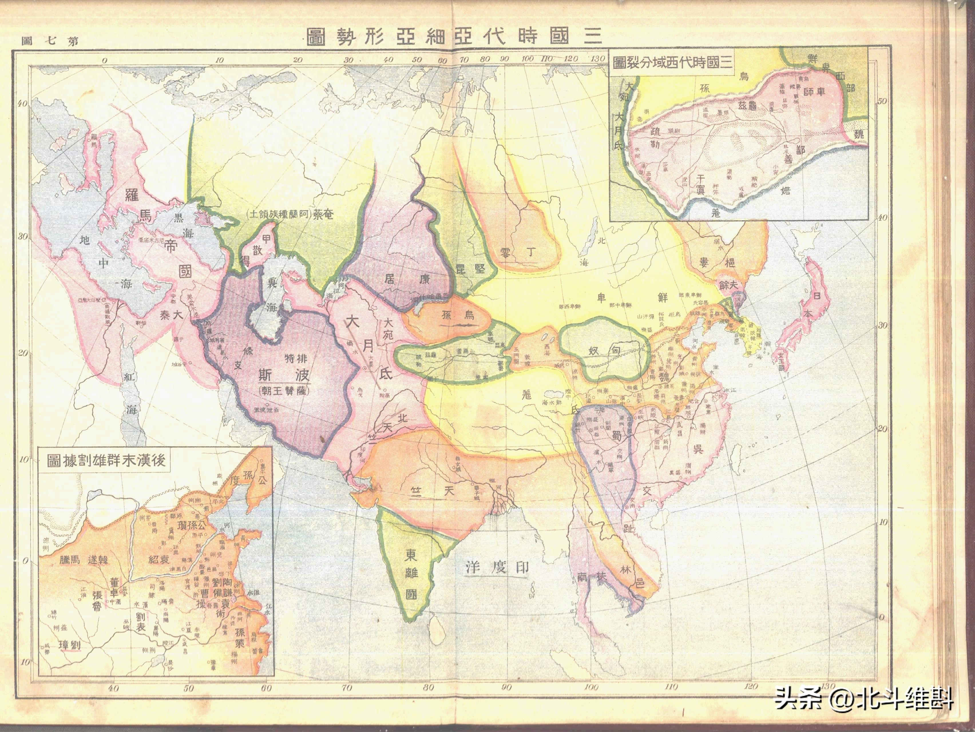
The situation in Asia did not change significantly during the Western Jin Dynasty and the Three Kingdoms period, so there is no need to say more. However, this map extends Japan's territory to the Hokkaido Island area, which is incorrect because Japan's jurisdiction here was very late.

The seventh map is a map of Asia during the Southern and Northern Dynasties, mainly the early Southern and Northern Dynasties. At that time, the two dynasties of Northern Wei and Liu Song were confronting each other in mainland China, while Rouran was rising in the desert. The Roman Empire in the west has been divided into Eastern Rome and Western Rome, and Eastern Rome governs the Asian part. In West Asia, the Persian Sasanian dynasty continued to expand and occupied large areas of the Arabian Peninsula. In South Asia, the Gupta dynasty emerged, the second unified dynasty in Indian history.
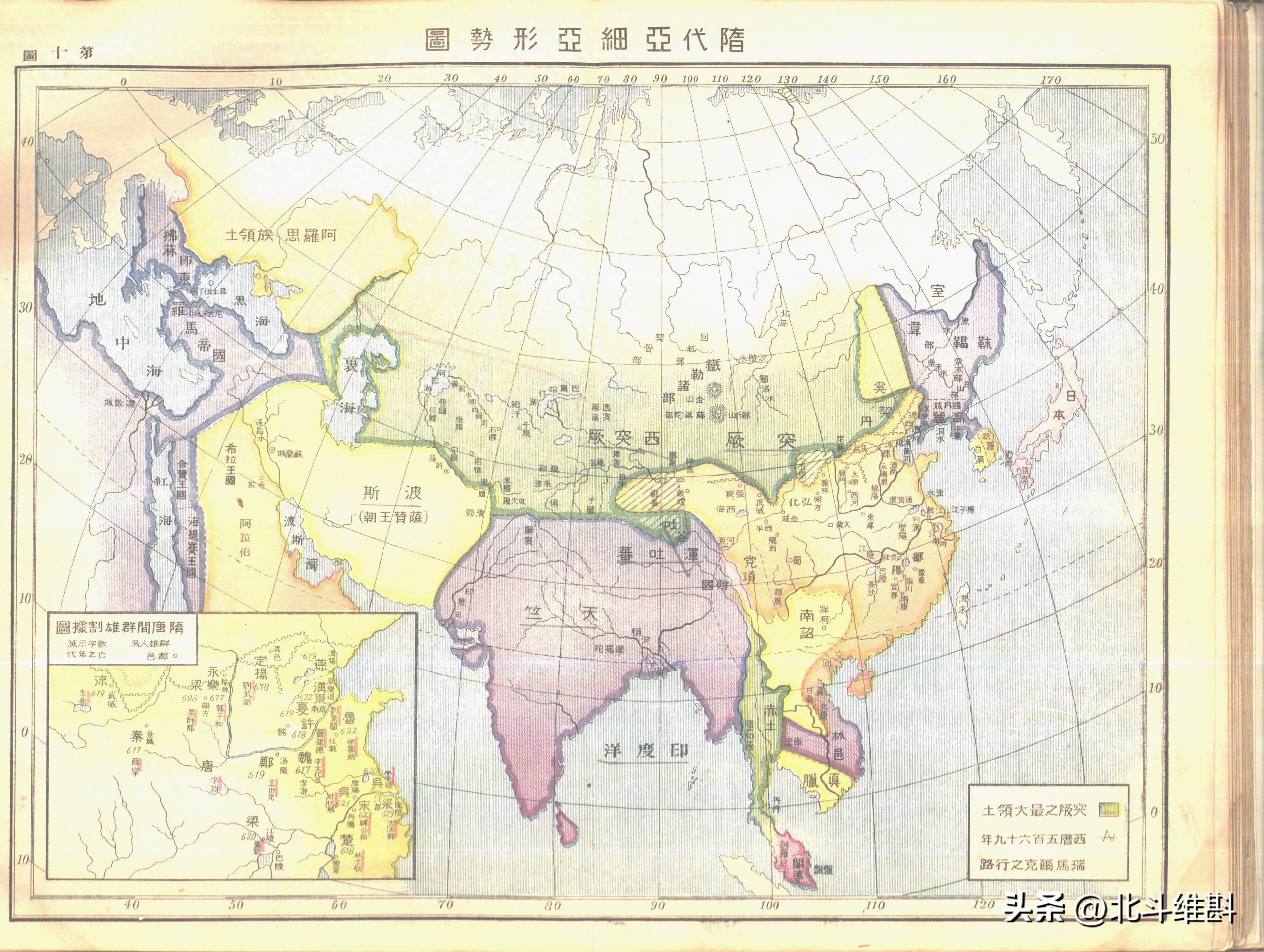
The eighth is a map of Asia during the Sui Dynasty. There are serious errors in the East Asian part of this map. For example, the Nanzhao Kingdom was not established at that time, but Nanzhao was marked in Yunnan. During the Sui Dynasty, the Turks were powerful. As can be seen from the map, the Turkic territory extended from the Greater Khingan Mountains in the east to the Caspian Sea in the west. It was divided into two parts, the East Turks and the West Turks, with a vast area. In Western Asia, the Sasanian dynasty of Persia reached its zenith. It is inappropriate to draw the Tibetan Plateau and India as one plate on the map.
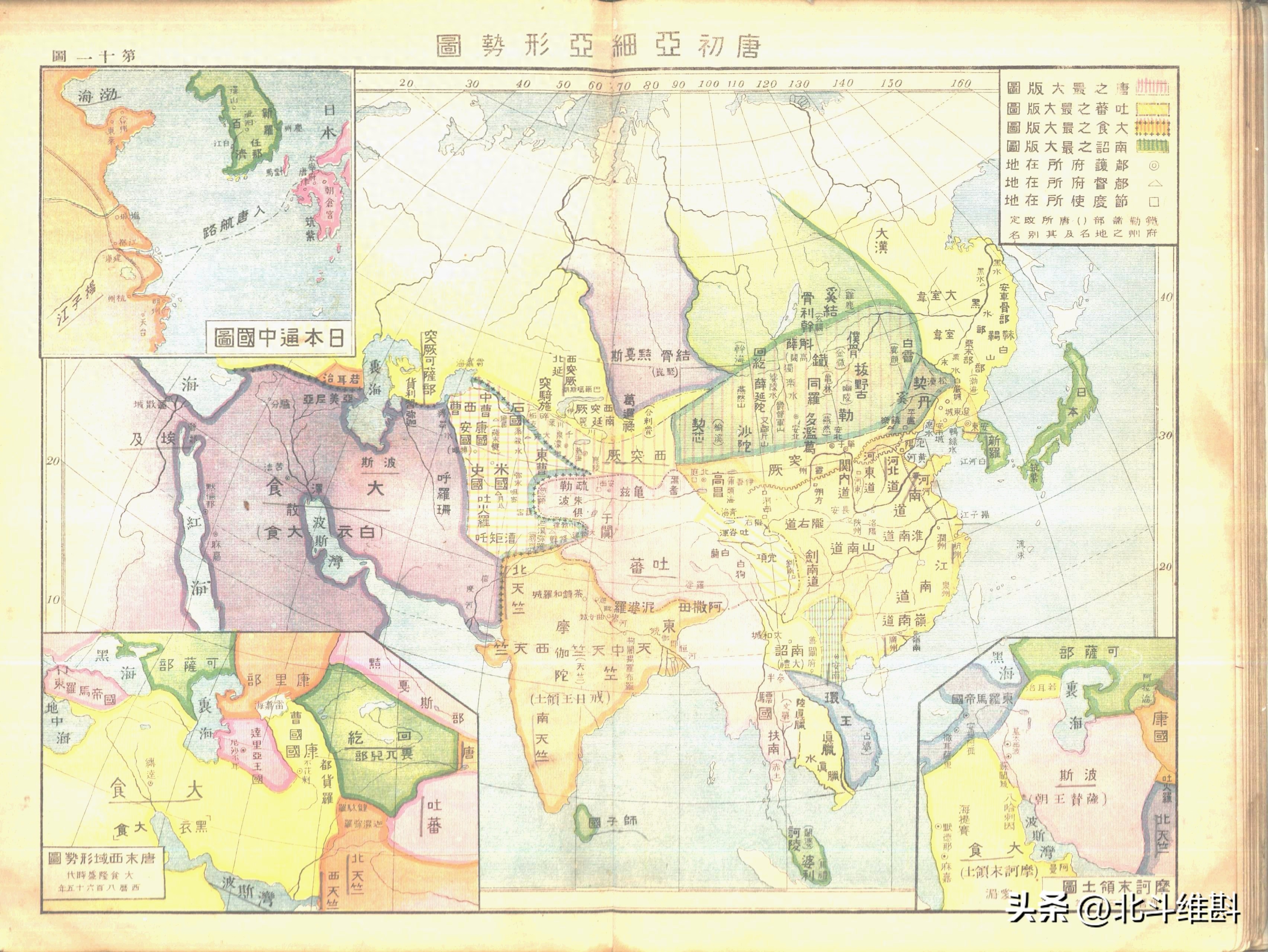
The ninth map is a map of Asia during the Tang Dynasty. The areas with vertical lines on the map are areas where the Tang Dynasty later expanded, including the Mongolian Plateau and the Western Regions, reaching the Aral Sea in the west. It seems that the Tang Dynasty's territory reaching the Aral Sea is recognized by both the East and the West. The empire that existed at the same time as the Tang Dynasty was the Arab Empire, which unified West Asia and North Africa, eliminated the Sasanian dynasty of Persia, and eventually bordered the Tang Dynasty. The Gupta dynasty in South Asia has split into several parts.
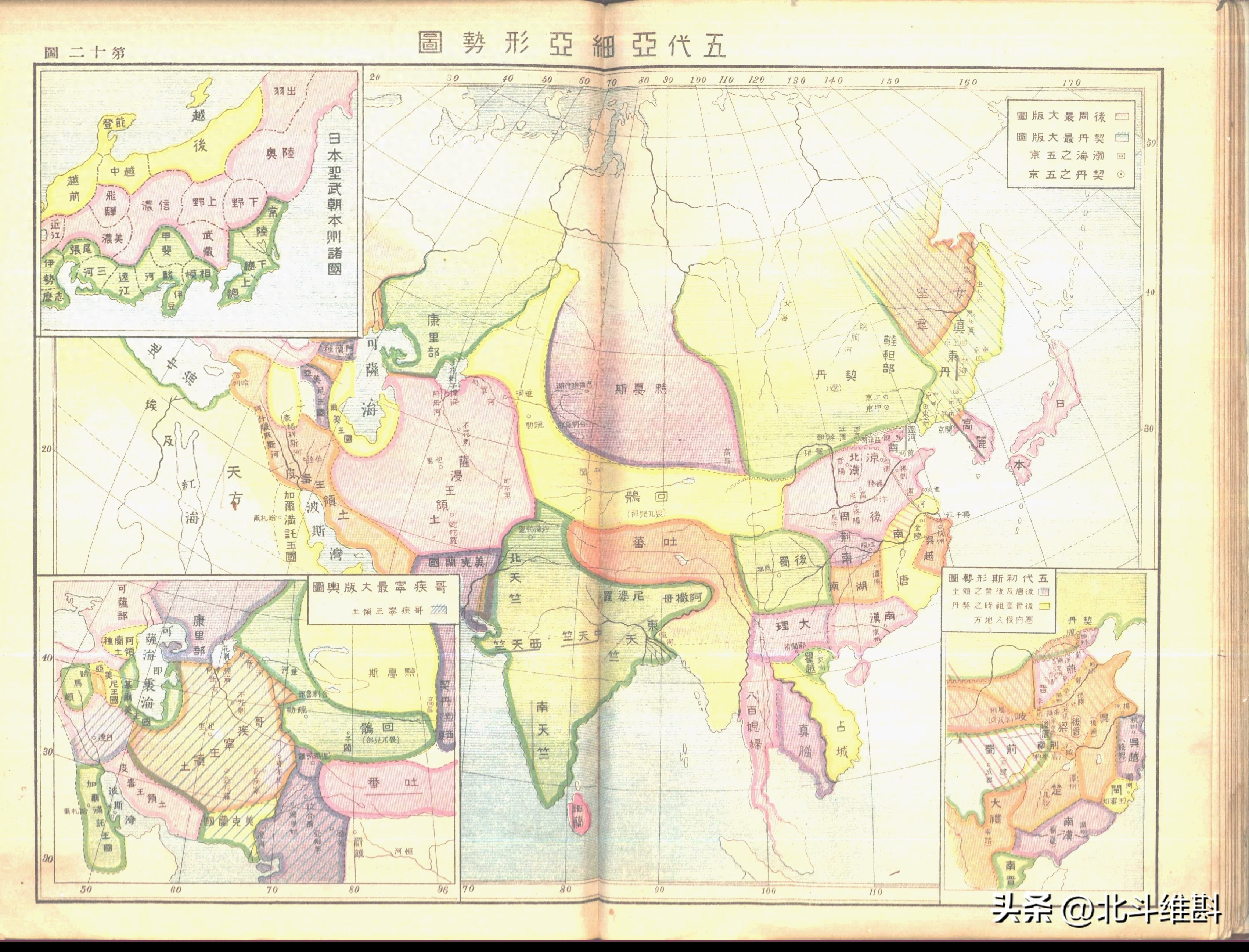
The tenth is a map of Asia during the Five Dynasties period. At that time, the Khitan was rising in the north. The Khitan in this map had expanded to the Lake Baikal area, which was obviously different from the map drawn in China. During this era, the Arab Empire also split, Persia gained independence, and the Turks established the Samanid dynasty here.
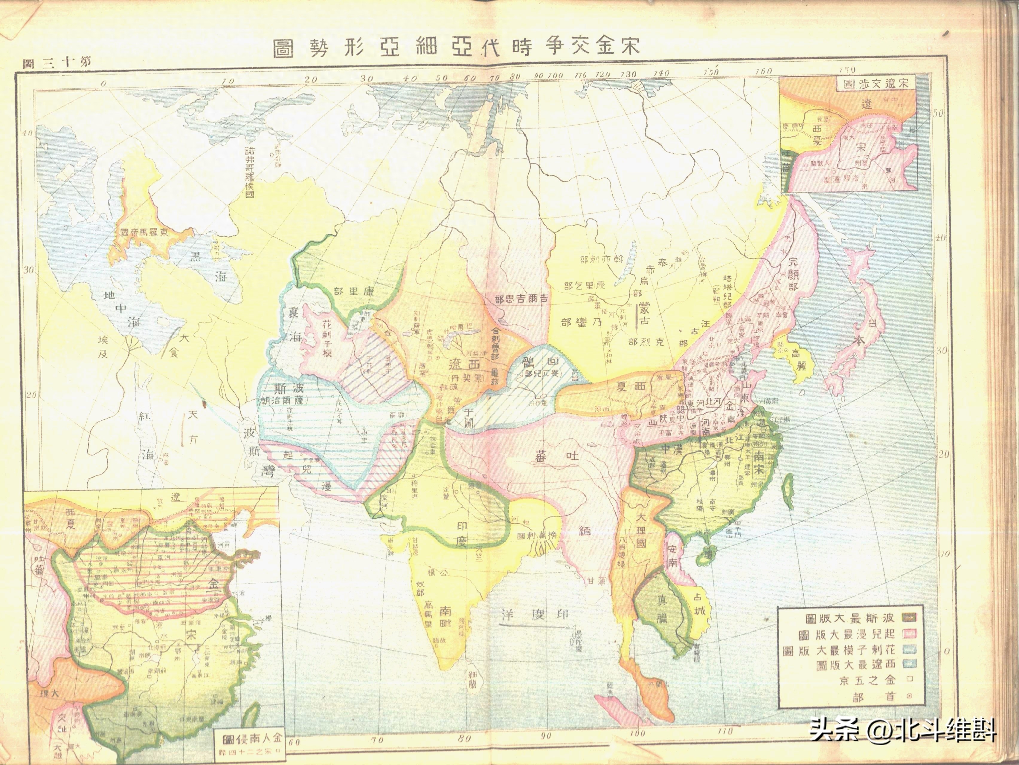
The eleventh picture is a map of Asia during the Southern Song Dynasty and the Jin Kingdom. At that time, there were three pillars in mainland China: the Southern Song Dynasty, the Jin Dynasty, and the Xixia Dynasty. There were the Mongolian tribes in Mobei, the Western Liao Dynasty in the Western Regions, and Dali in Yunnan. The Dali Kingdom in the picture has reached the Indian Ocean. In fact, there was the Bagan Dynasty in Myanmar at that time, and it was the Yuan Dynasty that defeated Bagan. In West Asia, two Turkic dynasties, the Seljuk Empire and the Khwarezm Empire, emerged successively.
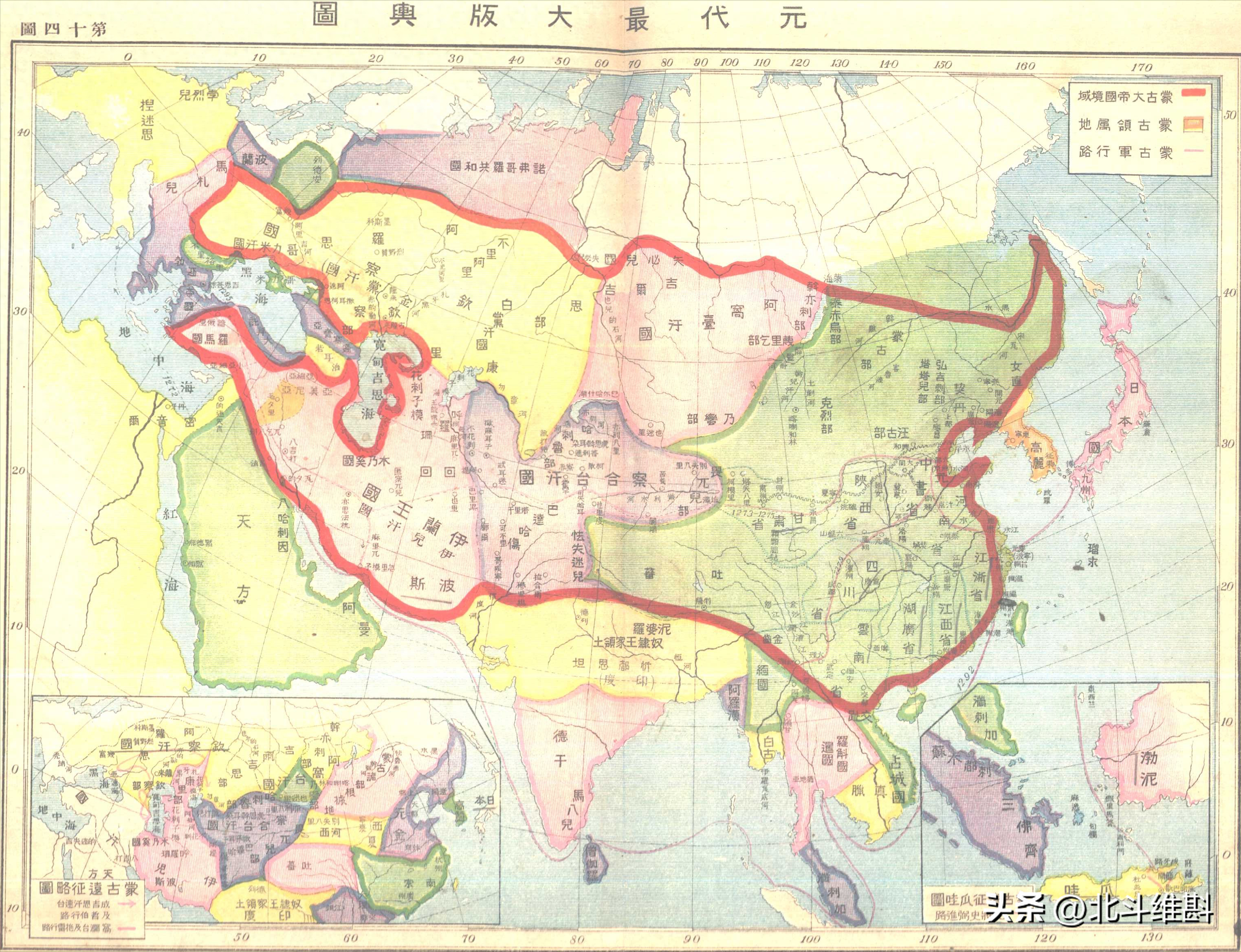
The twelfth picture is the territory of the Yuan Dynasty. The red circle is the territory of the Mongol Empire, including the Yuan Dynasty and the four Mongol Khanates. Tan Qixiang's map draws the northernmost point of the Yuan Dynasty to the Arctic Ocean, while this map draws the northernmost point of the Yuan Dynasty to Lake Baikal and the Outer Xing'an Mountains. Except for the territory of the Tan Qixiang system, most maps draw the northern end of the Yuan Dynasty to the north of Lake Baikal.
The thirteenth map is a map of the late Yuan Dynasty and early Ming Dynasty. At that time, the Yuan Dynasty had collapsed and the feudal lords in mainland China were divided. The Ogedei and Ilkhanate states have also collapsed, and the Timurid Empire has emerged in West Asia. On the Turkish peninsula, the Ottoman Empire had begun to emerge.

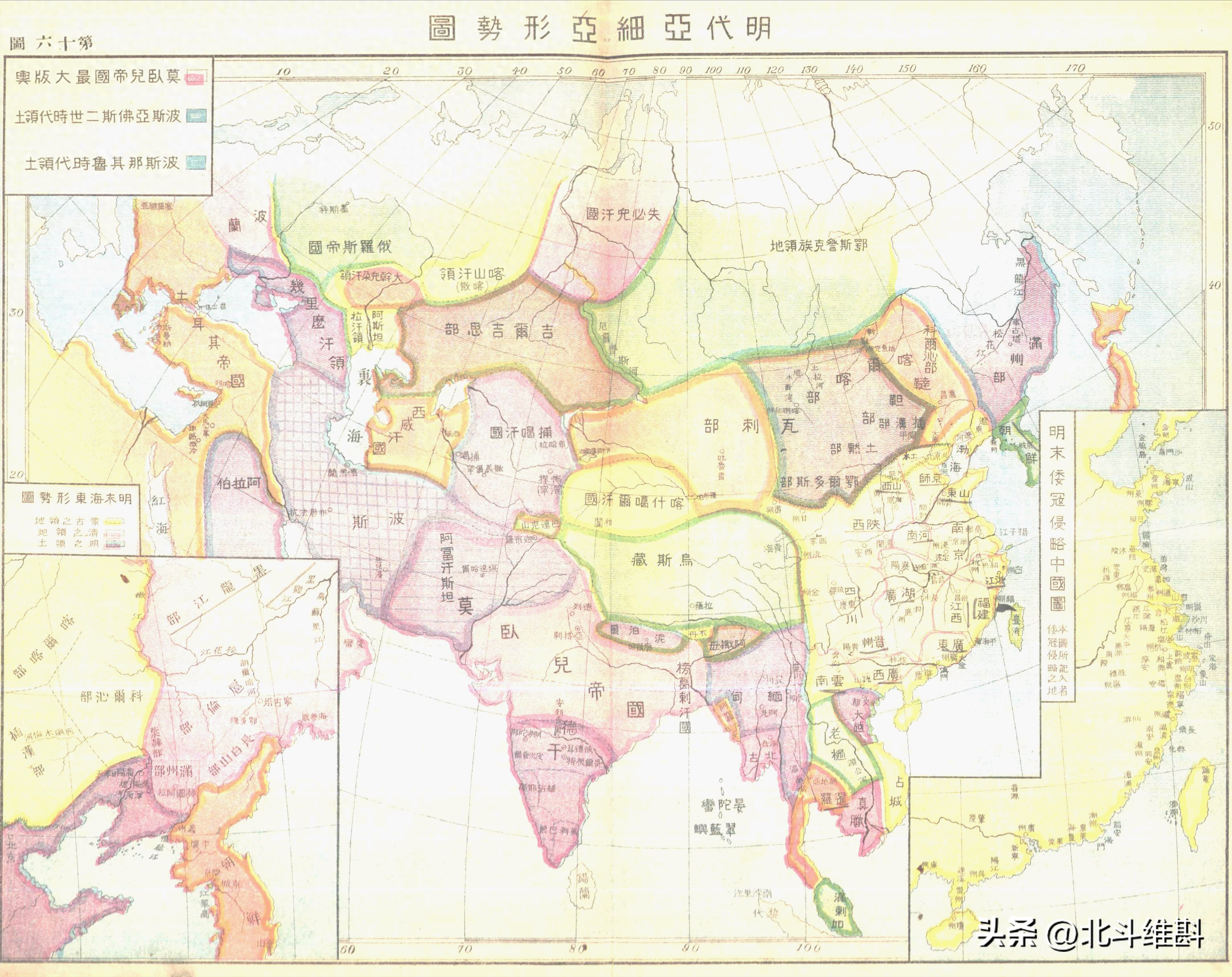
The fourteenth map is a map of Asia during the Ming Dynasty. At that time, the Ming Dynasty failed to fully inherit the territory of the Yuan Dynasty and was basically limited to the south of the Great Wall. A confrontation between the Tatars and the Oaras occurred in Mobei. In the northeast, there are Jurchen tribes, in Qinghai-Tibet, there are Uzbek tribes, and in the northwest, there is Chagatai. In West Asia, the Timurid Empire had collapsed, and Turkey had destroyed the Eastern Roman Empire. In South Asia, the Mughal Empire was being established.
The fifteenth is a map of Asia during the Qing Dynasty. The areas with horizontal and vertical lines in the picture are the areas annexed by the Qing Dynasty, including the Mongolian Plateau, the Qinghai-Tibet Plateau and the Western Regions. However, the island of Taiwan on the map is not painted in the same color as the mainland, and there are no horizontal or vertical lines drawn on it. This is very problematic. At that time, the Russian Empire had annexed all of Siberia and became China's largest neighbor. The Mughal Empire in South Asia was divided. The Persian and Turkish empires in West Asia were suffering under the invasion of Russia and Western countries.

Generally speaking, the first few of this set of historical maps of Asia are full of errors, while the latter ones are relatively accurate, but there are also many problems. It can be seen that the author's level of this set of maps is relatively limited. So far, I have not seen a very satisfactory historical map of Asia. It is very difficult to make a historical map of China, let alone a historical map of Asia.

Articles are uploaded by users and are for non-commercial browsing only. Posted by: Lomu, please indicate the source: https://www.daogebangong.com/en/articles/detail/min-guo-shi-qi-de-ya-zhou-li-shi-di-tu-cuo-wu-bai-chu-qin-chao-ju-ran-he-luo-ma-di-guo-bing-lie.html
 支付宝扫一扫
评论列表(196条)
测试